This website uses cookies, which are small text files that the website puts on your device to facilitate operation. Cookies help us provide a better service to you. They are used to track general user traffic information and to help the website function properly.
Feature count in area: 18, by county: Dublin: 16, Wicklow: 7, Kildare: 1, of which 6 are in both Dublin and Wicklow,
OSI/LPS Maps: 43, 50, 56, AWW, EW-DM, EW-WE, EW-WW
Highest Place: Kippure 757m
Starting Places (77) in area Dublin: Allagour Road, Ballinascorney Golf Club, Ballylerane, Ballylow Bridge, Ballyreagh Wood, Ballyross Forest, Ballysmuttan Long Stone, Barnaslingan Wood, Bohernabreena North CP, Boranaraltry Bridge, Bray Harbour, Cabinteely House, Cannon's Corner, Carrickgollgan, Castelkelly Bridge, Clonkeen Road South, Cloon Wood Cp, Cransillagh Brook , Crone Wood CP, Cruagh Forest Recreation Area, Cruagh Road Hairpin, Curtlestown Wood CP, Dunnes Bank, Enniskerry, Fernhill Estate, Gap Road, Garadhu Road, Glencree Reconciliation, Hell Fire Wood CP, Johnnie Fox Pub, Kilbride Army Camp Entrance, Kilgobbin Lane, Killakee Car Park, Killiney Hill Carpark, Kilmashoge Forest CP, Kilsaran Quarry, Kippure Bridge, Kippure Estate, Kippure Transmitter Gate, Knockbrack, Knockree west, Lackan Wood S, Lamb Doyles, Laughanstown Luas, Lee's Lane, Liffey Bridge, Liffey Head Bridge, Lough Bray Lower, Lough Bray Upper, Lynch's Park Road, Marley Park CP, Novara Avenue, Bray, Old Wicklow Way entrance, Pavilion Theatre, Pine Forest Road, Putland Road, Raheenoon, Rathmichael RC Church, Rathmichael Wood CP, Sally Gap, Sally Gap N, Seahan 265', Seahan 300', Sean Walsh Park, Seefin Trailhead, Shankill Byrnes Bar, Shankill Tributary Bridge, Slademore Road, Sraghoe Brook, St Catherine's Park, The Lamb Hill, The Scalp, Tibradden Forest Recreation Area, Tibradden Lane, Ticknock Forest, Vance's Lane, Wyattville Close
Summits & other features in area Dublin: N: Howth: Ben of Howth 171m N: Naul: Knockbrack 176m S: Dublin South East: Carrickgollogan 275.2m, Glendoo Mountain 585.1m, Killiney Hill 153.5m, Knocknagun 555.3m, Montpelier Hill 383m, Prince William's Seat 553.5m, Tibradden Mountain 466.2m, Two Rock Mountain 536m S: Kippure & Kilbride: Corrig Mountain 617.1m, Kippure 757m, Seahan 647.3m, Seefin 620.6m, Seefingan 722.9m S: Saggart: Cupidstown Hill 378.6m, Knockannavea 400.8m, Saggart Hill 396.9m
Note: this list of places may include island features such as summits, but not
islands as such.
Carrickgollogan, 275.2mHill Carraig Uallacháin A name in Irish,
Place Rating ..
(Irish: Carraig Uallacháin, meaning rock of Uallachán), Dublin County in Leinster province, in Binnion Lists, Carrickgollogan is the 1222th highest place in Ireland.
Grid Reference O23123 20062,
OS 1:50k mapsheet 50 Place visited by: 148members, recently by: NualaB, nupat, Tommer504, benjimann9, Theresa, IainB, markv, owen, Ansarlodge, megk971, michaelseaver, childminder05, srr45, Joe90, BrianKennan
I visited this place: NO (You need to be a logged-in member for this.)
Short or GPS IDs, 6 char: Crc275, 10 char: Crckglgn Linkback: https://mountainviews.ie/summit/1180/
Gallery for Carrickgollogan (Carraig Uallacháin) and surrounds
Summary
for Carrickgollogan (Carraig Uallacháin):
Simple ascent to distinctive hill
Summary created by Colin Murphy
2019-07-25 10:54:57
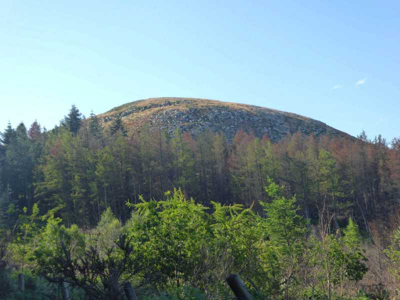
Picture: The dome of Carrickgollogan
Start at CGologan (O22548 20346), a forest entrance, where there is parking for several cars. Follow the gently rising forest track east, which then curves around to the south, the rocky dome of the hill appearing on the right. The track splits just below the summit - take the right hand path, which then curves up and around the dome, becoming a very rocky, narrow track which will take you all the way to the top. The summit is completely clear of forestry and presents fine panoramic views. 15minutes from car to top.
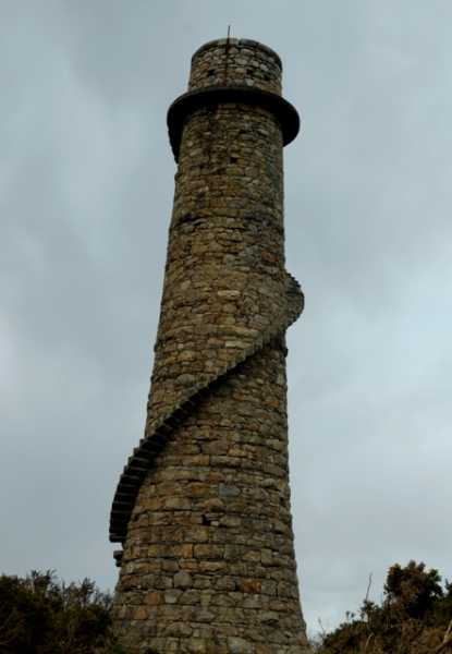
Climbed Carrickgollogan today started at CGologan (O22548 20346), followed directions from previous comments, it took 11mins from the car park to the summit. The views were fantastic today, noticed chimney like structure poking its head above trees to the south from summit. Decided to investigate, the structure is a Leadmine Chimney Flue. The mines were called Ballycorus Lead Mines which opened in 1807, closed in 1913. This Chimney flue is the only example of such a one to have been built in Ireland. So if you have the inclination to climb Carrickgollogan, it is well worth paying a visit to this interesting site. Linkback: mountainviews.ie/summit/1180/comment/15935/
Read Less
Read More
Nice little hill
by muschi
20 Jan 2014
Visited this summit in early Dec 2013, looking for foliage to make an advent wreath, there are many mature Noble Fir trees throughout the plantation.
There is a car park on Murphy's Lane at CGologan (O22548 20346). From there walk East along a good track through the wood to the summit, which is cone shaped, clear of trees and offers good views of the surrounding area. Linkback: mountainviews.ie/summit/1180/comment/15797/
Read Less
Read More
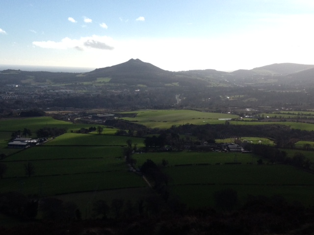
Picture: View south from the summit
Satisfying little hill
by Onzy
8 Feb 2014
It's a surprisingly enjoyable short walk to Carrickgollogan from the carpark on Murphy's Lane. The summit is a prominent hump in view ahead of you for most of the walk. The climb onto the summit could, at a stretch, be called a scramble. A worthwhile addition to the lists. Linkback: mountainviews.ie/summit/1180/comment/15837/
Read Less
Read More
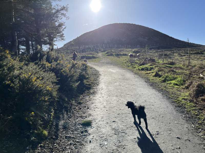
Picture: Approaching the summit
A hill close to my heart
by hibby
18 Feb 2024
I grew up near Carrickgollogan, but it was better known as Kattie Gallagher, or just "the hill". The view from our kitchen window was dominated by the N-S ridge of the hill, with the handsome bald dome of the summit at one end and the lead mines chimney at the other. Over the course of the year the sun set at different points along the ridge.
It is deservedly a very popular place to walk, with wonderful views to the coast and nearby hills. There's a good network of forest roads and tracks, mainly firm underfoot. There is a short section near the chimney that is usually muddy.
Today we went up with our recently adopted dog, Benji. We parked in the car park on Murphy's Lane and walked directly to the summit, which took about 15 minutes. The ascent of the quartzite summit dome is steep enough to create a sense of achievement while still being manageable for children and small dogs!
So I was just up this hill this afternoon for my second time. Lovely easy walk, did it from my front door :) The summit is very obvious with lovely views. I have uploaded a GPS route also. While up here it is well worth the trip over to the chimney flue also! Linkback: mountainviews.ie/summit/1180/comment/15941/
Use of MountainViews is governed by conditions and a privacy policy.
Read general information about the site. Opinions in material here are not necessarily endorsed by MountainViews.
Hillwalking is a risk sport. Information in comments, walks, shared GPS tracks or about starting places may
not be accurate for example as regards safety or access permission. You are responsible for your safety and your permission to walk.
See the credits and list definitions.


 Our Facebook page.