Cookies.
This website uses cookies, which are small text files that the website puts on your device to facilitate operation. Cookies help us provide a better service to you. They are used to track general user traffic information and to help the website function properly.
Features
Nearby features appear when you click the map.
Declutter tracks on map.
Place Search
Video
X
Pub: by
West Clare Area , NW: Burren West Subarea
Feature count in area: 14, all in Clare, OSI/LPS Maps: 51, 52, 57, 58
Highest Place: Slievecallan 391m

Starting Places (16) in area West Clare:
Abbey Hill, Ballyvaughan, Ballyvelaghan Lough, Ben Dash, Derroolagh, Feenagh, Fermoyle Cottage, Glenfort, Leimaphuca, Lough Gaelan, Murroogh, Murrooghtoohy CP, Slieve Callan Wind Farm, Slieve Elva, Slievecarron, Toberkieran

Summits & other features in area West Clare:
Cen: Ennistymon Hills: Clifden Hill 189m, Knocknalarabana 204m
NE: Burren East: Abbey Hill 240m, Bouleevin 222m, Knockanes 205m, Mullagh More 180m, Slievecarran 326m
NW: Burren West: Aillwee 304m, Gleninagh Mountain 316.1m, Slieve Elva 344m
S: Ennis Hills: Ben Dash 267m, Cloontohil 190m, Slieveacurry 255m, Slievecallan 391m

Note: this list of places may include island features such as summits, but not islands as such.
Rating graphic.
Gleninagh Mountain, 316.1m Hill
Place Rating ..
, Clare County in Munster province, in Binnion Lists, Gleninagh Mountain is the 1122th highest place in Ireland. Gleninagh Mountain is the second most northerly summit in the West Clare area.
Grid Reference M17900 09500, OS 1:50k mapsheet 51
Place visited by: 76 members, recently by: learykid, eamonoc, cclair, mdoc1969, JoHeaney, Tifred, paulbrown, Ghreallaigh, abcd, obrien116, melohara, wwwalker, marcel, conorb, therealcrow
I visited this place: NO (You need to be a logged-in member for this.)
Longitude: -9.227281, Latitude: 53.129987, Easting: 117900, Northing: 209500, Prominence: 133m,  Isolation: 5.8km, Has trig pillar
ITM: 517867 709531
Bedrock type: fossiliferous limestone with Davidsonia, (Aillwee Member (upper))

  Short or GPS IDs, 6 char: GlnnMn, 10 char: GlnnghMntn

Linkback: https://mountainviews.ie/summit/1123/
Gallery for Gleninagh Mountain and surrounds
No summary yet for this place .
Member Comments for Gleninagh Mountain
Comment create / edit display placeholder

            MountainViews.ie picture about Gleninagh Mountain
Picture: Grikey it's a Clint, hey Clint it's a Grike
Clints and Grikes - watch your footing
by wicklore 30 Apr 2014
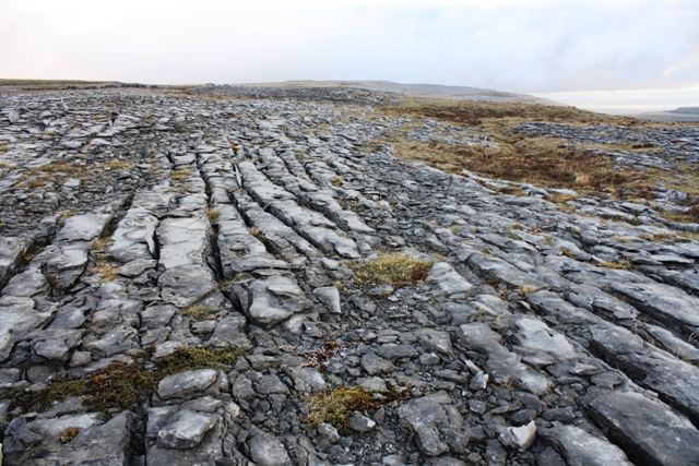
The Burren is a 300 sq km region of Co. Clare which is famous for its karst landscape. This manifests itself as magnificent endless exposed limestone plateaus, rocky hills and dramatic natural clean-cut steps and stairs and blocks of rock. Beneath lie breathtaking cave systems that are still being explored. While walking on the plateaus one encounters these ‘blocks’ of rock which are called ‘clints’. The cracks or fissures between them are called ‘grikes’. These require care as the rock of the ‘clints’ can be fractured and displace, and an unplanned step into a ‘grike’ could result in a leg or foot injury.

With two hours available early one morning I completed a compact circuit of Gleninagh. I started to the south of Gleninagh at Feena (M18995 07020). This is the start of a decent track that leads over the southern shoulder of Gleninagh. I followed the track uphill to the crest of where it crosses the long ridge of Gleninagh. I crossed the wall at 
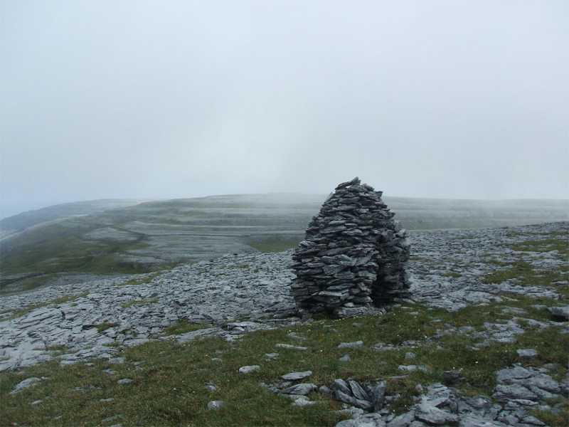
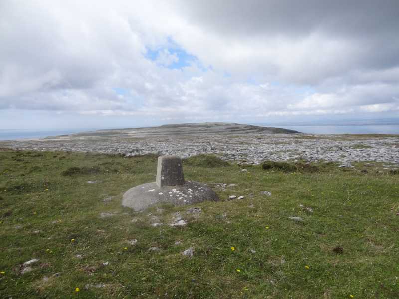
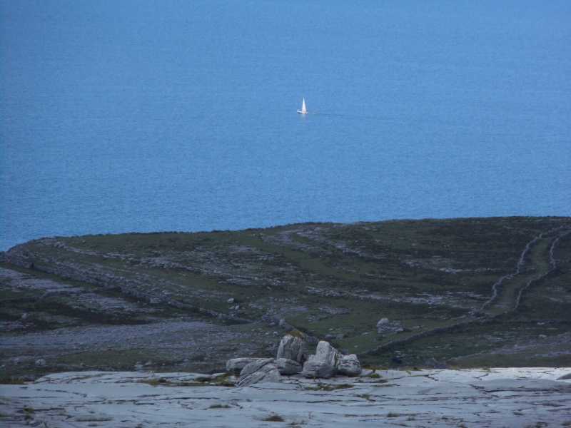
A (M18259 07104). Then began a delightful 2km walk north across the best of the Burren karst landscape. This involved negotiating the endless clints and grikes of the exposed limestone. There are also lots of drystone walls to cross and peculiar flora abounds in the cracks and fissures all around. Overall it’s a lovely Burren experience. The approach ascent is very gradual. After 2km the summit mound of Gleninagh appears. It is disappointingly topped at by an ugly stumpy concrete trig pillar at B (M17910 09508). (Yes this trig pillar is quite ugly as these things go). This is somewhat mitigated by the views which are very pleasant. It’s more likely you will be looking out rather than down at the trig pillar anyway.

I continued down to the east where there was some steep ground, including limestone shelves, until I reached the col below at C (M18659 09429). I followed a track from the col south all the way back to my car. This track completely disappears in places despite being marked on the map. I believe this is a reflection of the turlough lakes that appear and disappear seasonally in this region - the temporary lakes having wiped out evidence of the track in places. One example of the track disappearing is encountered at D (M18711 08933). Some very wet ground at times in otherwise dry underfoot conditions lend weight to this conclusion of turloughs being the cause of the intermittent track.

The small track becomes tarred eventually as you begin to pass through a series of gates. However there are no houses (besides a half-built one) until you reach your car parked near a farmhouse at the starting point. This is a delightful walk of about two hours that allows fine views north across Galway Bay to Connemara and the distant summits there as well as the surrounding features of this most curious karst landscape.

My GPS track for this walk can be found in the MV track section here: http://mountainviews.ie/track/2512/ Linkback: mountainviews.ie/summit/1123/comment/16047/
Read Less
Read More

            MountainViews.ie picture about Gleninagh Mountain
Picture: Gleninagh in the distance
Edge of the World
by Geansai 10 Feb 2014
What this area lacks in altitude it makes up for in atmosphere with the backdrop of Galway Bay, the Atlantic Ocean and the eerie landscape. Gleninagh is one of the hills you can see on the other side of the bay from various parts of Galway city. The second last one before the north Clare coastline gives way to the Atlantic. The photo was taken from a little way below the summit of the westernmost high spot looking east to Gleninagh. Futher west on the descent from here down towards the coast road is the iron age fort Cathar Dhun Iorais who's ruins resemble a circular stone wall. I used the lonely planet walking guide to Ireland circular route heading east up a backroad from Fanore before heading cross country and approaching Gleninagh from the south. Gleninagh is marked by a small pale trig pillar. Once you get off the road navigation would be very tricky in mist and you always have to watch your footing on this terrain. The hike down the rocky terraces from Gleninagh and up to the spot this photo was taken wouldn't want to be done in a hurry. After Cathar Dhun Iorais you don't have to descend all the way to the coast road. There's a clear grassy walking track that heads back to Fanore. Linkback: mountainviews.ie/summit/1123/comment/15845/
Read Less
Read More

            MountainViews.ie picture about Gleninagh Mountain
Picture: Summit trig on Gleninagh looking to point 314.
A fine loop walk
by hivisibility 17 Aug 2015
One can also access Gleninagh via the excellent Black head loop walk (Route 37) in Helen Fairbairn's great book Ireland's best walks. "" Starting from the church in Fanore continue east for approx 3.5km on a minor road until you meet a marker for the Burren way leading up a stone passage to the left. Continue up this path until it levels out and then turn left over a stone wall to strike out cross country for Gleninagh approx 2.5km away, which can clearly be seen roughly northwest. Pleasant walking alternating between limestone pavement and grass. Sea views open up on arrival which if you''re lucky will include Galway city, and the Bens and the Maamturks off in Connemara. To complete the circuit leave the trig and head northwest to the neolithic cairn of Dobhach Brainin on point 314, with the Aran islands now taking centre stage. From this point your concentration levels are tested as you search for easier descent points through the cliffs but nothing major. Continue to the Iron age fort of Cathair Dhúin Irghuis and drop steeply to the grass track already mentioned and swing left to return to Fanore. Linkback: mountainviews.ie/summit/1123/comment/18255/
Read Less
Read More

            MountainViews.ie picture about Gleninagh Mountain
Picture: Looking down on the R477 Road
A sweeping vista of the Aran Islands, Fanore Beach and Galway Bay
by Damian120 10 Jul 2018
This hiking trail up over Gleninagh Mountain serves up a great example of the typical Burren limestone Karst, following traditional old and now disused green lane-ways. Elevated mountain paths form the initial part of the Blackhead Looped Hiking Trail taking in striking views of Fanore Beach and Gleninagh Mountain. It also features some towering and wonderful views of Galway Bay, the north Connemara shoreline and the Aran Islands and is also rich in the innumerable Burren wild flowers that scatter this unique environment. Linkback: mountainviews.ie/summit/1123/comment/19975/
Read Less
Read More

            MountainViews.ie picture about Gleninagh Mountain
Picture: A sailing boat out on Galway Bay
Fanore to Ballyvaughan off road.
by TommyV 4 Dec 2018
Starting in Fanore at the start of the Blackhead trail at Muroo (M14638 09273), this route follows an old cattle trail as far as Blackhead. Leave the trail at E (M15492 11648) heading south east to the impressive Caherdoonish fort at F (M15796 11412). before leaving the trail to ascend Doughbraneen passing Caherdooneerish Stone Fort on the way. After taking in the fort, continue heading south east for about 1.5km to the cairn at spot height 314. The trig point on Gleninagh lies another kilometer south east from here.

From Gleninagh, there is a short descent east before a short climb up to Cappanwalla . The summit here is quite broad with lots of semi walls that look like horse jumps which can never be used due to the not horse friendly terrain underfoot!! At the south east side of this summit at G (M20553 07226) lies an unusual distraction. An alien like structure that has some electronics inside it, I assume it's some sort of weather station! From here carefully pick your way down to the road, use the Castle as a reference point and aim to hit the road to the left of the castle. Once on the road take the first right and after about 200 meters look for a gap in the wall at H (M22033 07073). Follow this trail in to Ballyvaughan for some well earned dinner and maybe even a pint! Linkback: mountainviews.ie/summit/1123/comment/20091/
Read Less
Read More
EDIT Point of Interest
text
Videos
(none available)
Recent Contributions
x
Conditions and Info
Use of MountainViews is governed by conditions and a privacy policy.
Read general information about the site.
Opinions in material here are not necessarily endorsed by MountainViews.
Hillwalking is a risk sport. Information in comments, walks, shared GPS tracks or about starting places may not be accurate for example as regards safety or access permission. You are responsible for your safety and your permission to walk.
See the credits and list definitions.

OSi logo
OSNI/LPS logo
Open Street Map
(Various variations used.)
British summit data courtesy:
Database of British & Irish Hills