This website uses cookies, which are small text files that the website puts on your device to facilitate operation. Cookies help us provide a better service to you. They are used to track general user traffic information and to help the website function properly.
Feature count in area: 64, by county: Derry: 34, Tyrone: 39, of which 9 are in both Derry and Tyrone,
OSI/LPS Maps: 12, 13, 6, 7, 8
Highest Place: Sawel 678m
Starting Places (21) in area Sperrin Mountains: Altinure Road, Banagher Glen Nature Reserve, Barnes Gap Car Park, Crocknakin, Drumnaspar Picnic CP, Glenchiel Road, Glenedra Bridge, Glenelly Road, Parkreagh, Goles Road, Lough Ouske, Moneyneany Village, Moydamlaght Forest, Moydamlaght Road, Mullaghmore, Mullaghbane, Spaltindoagh, Sperrin Hamlet, Sperrin Heritage Centre, Sperrin Heritage Centre W, Sperrin Road, Barnes Top, Sperrin Road, Glashagh Bridge, Sperrin Road, Sperrin
Summits & other features in area Sperrin Mountains: E: Magherafelt Hills: Slieve Gallion NE Top 493.6m E: Magherafelt Hills: Slieve Gallion 526.6m N: Claudy Hills: Crockdooish 321m, Curradrolan Hill 270m, Eglish 277m, Letterlogher 249m, Mullaghmeash Hill 244m, Slieveboy 259m, Straid Hill 303m NE Cen: Glenelly North East: Barnes Top 456m, Craigagh Hill 460m, Crockbrack 526.1m, Knockanbane Mountain 441m, Meenard Mountain 620m, Meenard Mtn W Top 480m, Mullaghaneany 627m, Mullaghash 480m, Mullaghsallagh 485m, Oughtmore 569m, Spelhoagh 568m NE: Glenshane North: Benbradagh 465m, Boviel Top 454m, Carn Hill 448m, Carntogher 464m, Moneyoran Hill 414m NE: Glenshane South: Bohilbreaga 478m, Coolnasillagh Mountain 423m, Corick Mountain 430m, Crockalougha 407m, Mullaghmore 550m, White Mountain 537m NW Cen: Glenelly North West: Dart Mountain 619m, Dart Mountain North-West Top 525m, Learmount Mountain 489m, Learmount Mountain South Top 492m, Mullaghasturrakeen 581m, Mullaghcarbatagh 517m, Mullaghclogha 635m, Mullaghclogher 572m, Mullaghdoo 568m, Sawel 678m NW: Maheramason Hills: Clondermot Hill 220m, Gortmonly Hill 218m, Slievekirk 370m SE Cen: Glenelly South East: Carnanelly 562m, Carnanelly West Top 503.4m, Mullaghbane 467m, Mullaghturk 416m SE: Cookstown Hills: Cregganconroe 300m, Fir Mountain 362m, Oughtmore 382m SW Cen: Glenelly South West: Clogherny Top 408m, Craignamaddy 385m, Crocknamoghil 335m, Mullaghbolig 442m, Spaltindoagh 420m SW: Mullaghcarn: Curraghchosaly Mountain 416m, Mullaghcarn 542m, Mullaghcarn South Top 525m SW: Newtownstewart Hills: Bessy Bell 420m, Mullaghcroy 242m W: Strabane: Balix Hill 403m, Knockavoe 296m, Owenreagh Hill 400m
Note: this list of places may include island features such as summits, but not
islands as such.
Fir Mountain, 362mHill
Place Rating ..
, Tyrone County in Ulster province, in no lists, Fir Mountain is the 1035th highest place in Ireland.
Grid Reference H74715 85394,
OS 1:50k mapsheet 13 Place visited by: 25members, recently by: Tricia-Mulligan, garybuz, Paddym99, pdtempan, Oscar-mckinney, Carolyn105, Jai-mckinney, dregish, mallymcd, Hoverla, trostanite, eamonoc, NICKY, LorraineG60, MichaelG55
I visited this place: NO (You need to be a logged-in member for this.)
Short or GPS IDs, 6 char: FrM362, 10 char: FrMntn 362 Linkback: https://mountainviews.ie/summit/1089/
Gallery for Fir Mountain and surrounds
Summary
for Fir Mountain :
An isolated little top.
Summary created by Harry Goodman
2015-08-25 20:39:13
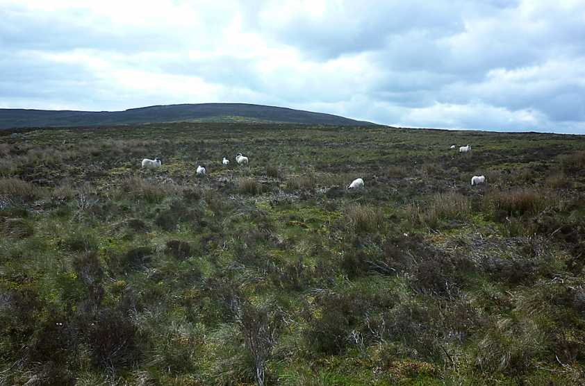
Picture: Looking to-wards Fir Mt from the NW.
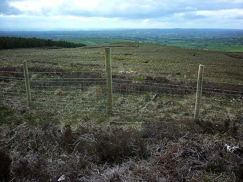
Take the B162 NW out of Cookstown and at A (H78405 83322) take a road on the left (Ballynagilly Road). Follow it along for some 4 km to pass a tree plantation on the right, part of Davagh Forest. Just beyond the Plantation park, with care, at the roadside beyond a metal gate B (H74477 84666). Cross the gate and make directly for the top, keeping to the left of an obvious knoll on the slope ahead. Cross a wooden gate into the next field to gain the high point of the hill just beyond a high barbed wire fence at C (H74718 85393).
There are nice views down over L Fea and Slieve Gallion, E to L Neagh, NNW to the higher Sperrins and S to the distant line of Cuilcagh. Up and back 1.7km, easily walked in less than 30 minutes.
I climbed Fir Mt. in June 2015 when completing my "new" Local 100 hills. I parked beside a gate into a field leading up to the hill B (H74477 84666). Once across, it was a gentle stroll up to the top. Initially I passed around the left side of an obvious knoll, crossed a wooden gate into another field and then a high barbed wire fence to gain the top and therein lies my tale. Strangely both the OSNI Sheet 13 for the Sperrins and the more detailed Sperrin Activity 1:25,000 scale maps show the spot height 262m as lying within the 250m contour at D (H747 853) yet there are two small 260m ring contours also shown nearby on these maps. When there I took a GPS reading of my considered high point C (H74718 85393). When I got home I looked at an earlier edition (1991) of OSNI Sheet 13 and found in that map that the spot height 262m was located within the more southerly of the two 260m ring contours. My roamer reading from this older map was E (H747 854) which corresponded very closely to my GPS reading on the hill. This said when there it is fairly obvious to the eye where the high point lies. Linkback: mountainviews.ie/summit/1089/comment/18270/
Use of MountainViews is governed by conditions and a privacy policy.
Read general information about the site. Opinions in material here are not necessarily endorsed by MountainViews.
Hillwalking is a risk sport. Information in comments, walks, shared GPS tracks or about starting places may
not be accurate for example as regards safety or access permission. You are responsible for your safety and your permission to walk.
See the credits and list definitions.


 Our Facebook page.