This website uses cookies, which are small text files that the website puts on your device to facilitate operation. Cookies help us provide a better service to you. They are used to track general user traffic information and to help the website function properly.
Feature count in area: 27, by county: Donegal: 27, Derry: 1, of which 1 is in both Derry and Donegal,
OSI/LPS Maps: 2, 3, 4, 6, 7
Highest Place: Slieve Snaght 614.6m
Starting Places (43) in area Inishowen: Adderville Upper, Barnes Bend, Bunacrick, Butlers Bridge, Carnaghan Presbyterian Church, Castruse Upper, Craignacoolagh, Craignamuck, Croaghglengad West, Crockavishane South, Diarmuid and Gráinne's Bed, Doherty's Dún, Dunree Bay Carpark, EEl Hole, Effishmore Upper, Evishbreedy Bridge, Five Fingers Strand, Gap of Mamore Grotto, Gap of Mamore Road, Gap of Mamore Viewpoint, Glack, Glasmullan, Golan Bridge Track, Goorey Hill, Grania's Gap, Gransha Árd, Green Hill, Leamacrossan Hill East, Lisfannon Beach, Lough Shivnagh, Lough Turk North, Magilligan Point View, Meenabroagh, Meenyollan River, Moor House, Mullagh, Pincher's Corner, Rashenny, Roosky Upper, Rowantree Hill, St Michael's Church, Stroove Beach, Tullagh Beach
Summits & other features in area Inishowen: Cen: Slieve Snaght: Damph 420m, Slieve Main 514m, Slieve Snaght 614.6m N: Malin: Croaghglengad 259m, Crockalough 282m, Soldiers hill 174m NE: North East Inishowen: Crockavishane 322m, Crocknasmug 327.5m, Grinlieve 371m NW: Urris: Binnion 250m, Bulbin 494m, Coolcross Hill 291m, Croaghcarragh 400m, Crockmain 460m, Dunaff Hill 230m, Mamore Hill 423m, Raghtin More 502m, Slievekeeragh 389m, Urris Hills 417m S: Iskaheen: Crockglass 397m, Eskaheen Mountain 418m, Greenan Mountain 241m, Holywell Hill 260m, Inch Top 222m, Leamacrossan Hill 392m, Mouldy Hill 312m, Scalp Mountain 484m
Note: this list of places may include island features such as summits, but not
islands as such.
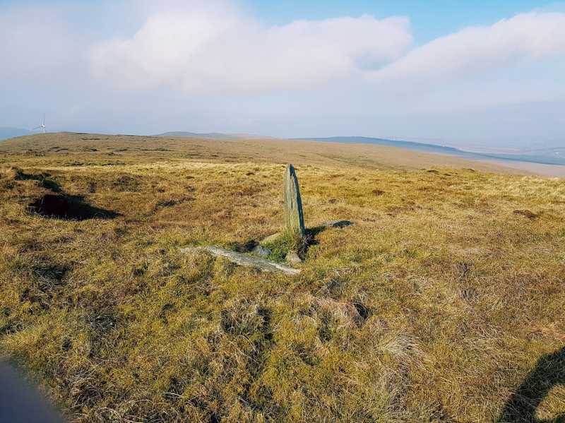
Crockglass, 397mHill
Place Rating ..
, Donegal County in Ulster province, in no lists, Crockglass is the 963rd highest place in Ireland.
Grid Reference C47392 31836,
OS 1:50k mapsheet 3 Place visited by: 17members, recently by: johncusack, ChrisC, eamonoc, trostanite, MichaelG55, LorraineG60, AntrimRambler, Peter Walker, Fergalh, NICKY, sandman, jmcg, mark-rdc, Harry Goodman, chalky
I visited this place: NO (You need to be a logged-in member for this.)
Access to this hill is via the farm track whose entrance is located at LeamHl E (C48207 33068) a public right of way,you have an option of parking here or driving with a vehicle having ground clearance to A (C47348 32540) parking for one vehicle. It is now only a short walk to the marked summit over reasonable ground.Many may care to visit Leamacrossan Hill as part of a longer walk. Linkback: mountainviews.ie/summit/1062/comment/18875/
Use of MountainViews is governed by conditions and a privacy policy.
Read general information about the site. Opinions in material here are not necessarily endorsed by MountainViews.
Hillwalking is a risk sport. Information in comments, walks, shared GPS tracks or about starting places may
not be accurate for example as regards safety or access permission. You are responsible for your safety and your permission to walk.
See the credits and list definitions.


 Our Facebook page.