Cookies. This website uses cookies, which are small text files that the website puts on your computer to facilitate operation. Cookies help us provide a better service to you. They are used to track general user traffic information and to help the website function properly.

Click to hide this notice for 30 days.
Welcome to MountainViews
If you want to use the website often please enrol (quick and free) at top right.
Overview
Detail
Zoom: ??
For more map options click on any overview map area or any detail map feature.
Detail Map Features
Showing 4 items:
Tara 155m,
Tracks:
2927, 13km 2446, 5km 2802, 1km
Find Suggested Walks
Find hill, mountain, island, coastal feature.
Videos
(none available)
Recent Contributions
Get Notifications

Esknabrock: Short and fairly sweet

Esknabrock: Have you got an hour?

Met Eireann launches 10-day mountain forecast

A very tough outing in Glen Etive

Knockalla: Anticlockwise loop walk.

Bloody Foreland: Easy going walk.

Tonduff: Some nice views, but unexciting summit

Windfarm eases access

Slieve Carn: Working Bog and Wind Farm

Carranarah: Electric Dreams

Access via rocky trail

Bockagh Hill: Short but Hard Bag.

Conditions and Info
Use of MountainViews is governed by conditions and a privacy policy.
Read general information about the site.
Opinions in material here are not necessarily endorsed by MountainViews.
Hillwalking is a risk sport. Information in comments, walks, shared GPS tracks or about starting places may not be accurate for example as regards safety or access permission. You are responsible for your safety and your permission to walk.
See the credits and list definitions.
Video display
North East Midlands Area   SE: Boyne Valley Subarea
Place count in area: 24, OSI/LPS Maps: 26, 27, 27A, 28, 28A, 28B, 34, 35, 36, 41 
Highest place:
Cornasaus, 339m
Maximum height for area: 339 metres,     Maximum prominence for area: 224 metres,

Places in area North East Midlands:
Cen: Ballyjamesduff:   Aghalion Hill 249m
Cen: Oldcastle:   Mullaghmeen 258mSlieve Na Calliagh 276mSpire of Lloyd 131mThe Hill of Mael 241m
E: Kingscourt:   Carrickleck Hill 173m
N Cen: Cavan Town:   Shantemon 218mSlieve Glah 320mTievenanass 261m
NE: Ballybay:   Bunnanimma 268m
NE: Carrickmacross:   Corduff 243m
NE: Castleblaney:   Mullyash Mountain 317m
NE: Cen Bailieborough:   Cornasaus 339mTaghart South 290m
NW Cen: Arva:   Bruse Hill 260m
NW: Aughavas:   Lugganammer 190m
S Cen: Crookedwood:   Cruckboeltane 199mKnockeyon 214m
S: Westmeath South West:   Knockastia 200m
SE: Boyne Valley:   Hill of Slane 160.4mMount Oriel 251mTara 155m
W: Ardagh:   Bawn Mountain 200m
W: Drumlish:   Corn Hill 278m

Note: this list of places includes island features such as summits, but not islands as such.
Rating graphic.
Tara Hill Teamhair A name in Irish, also Hill of Tara an extra name in English Ir. Teamhair [logainm.ie], poss. 'sanctuary' Meath County in Leinster Province, in Local/Historical/Cultural List, Dark micrite & calcarenite, shale Bedrock

Height: 155.0m OS 1:50k Mapsheet: 42/43 Grid Reference: N92004 59723
Place visited by 147 members. Recently by: FerdiaScully, Tomaquinas, morgan_os, grzywaczmarcin, MichaelButler, owen, MickM45, michaelseaver, cmcv10, sliabhdunner, flynnke, Aneta.jablonska, childminder05, pdtempan, Jess1832
I have visited this place: NO (You need to be a logged-in member to change this.)

Longitude: -6.611723, Latitude: 53.579513 , Easting: 292004, Northing: 259724 Prominence: 84m,  Isolation: 15.9km,   Has trig pillar
ITM: 691933 759744,   GPS IDs, 6 char: Tara, 10 char: Tara
Bedrock type: Dark micrite & calcarenite, shale, (Loughshinny Formation)

Tara is a royal place, in pre-history and in historic times 142 kings are said to have reigned in the name of Tara. The Coronation stone called the Lia Fail or Stone of Destiny has rested here down the ages. It was here that the most powerful of Irish kings held their great inaugural feasts. Tara is a sacred place in ancient Irish religion and mythology Tara was revered as a dwelling of the gods and an entrance place to the otherworld of eternal joy and plenty where no mortal ever grew old. Tara is a Celtic place and is one of the largest complexes of Celtic monuments in all of Europe. The first settlers came here 6,000 years ago, they and the Celts who followed choose Tara as a very special place. It has many important features, including the banqueting hall, the rath of the synods, the Kings Seat, Cormac's House and the highest and possibly most important of them all, the Mound of the Hostages.   Tara is the 1467th highest place in Ireland. Tara is the second most southerly summit in the North East Midlands area.

Linkback: https://mountainviews.ie/summit/1059/
COMMENTS for Tara (Teamhair) 1 of 1  
Follow this place's comments
MountainViews.ie Picture about mountain Tara (<i>Teamhair</i>) in area North East Midlands, Ireland
Picture: The Mound of Hostages as seen from beside the Lia Fail
 
The House of Cormac!
by Trailtrekker  10 Jan 2014
"Cernait, Grainne, Cormac, Fionn, t'was here they loved and lost and won. Their secrets lie 'neath Tara's soil, known only to the Lia Fail" Song of Tara.

On most of the MV ratings this hill fails miserably! It scores zero in terms of challenge and wilderness, it can't be linked with another hill and there is quiet a bit of walker damage. Unless you have the clearest of days, when you can see the Cooley and Mourne ranges, the view is quiet uninspiring and as you approach it you will barely notice that it is a hill. Yet having said this, it is one that we should all visit!

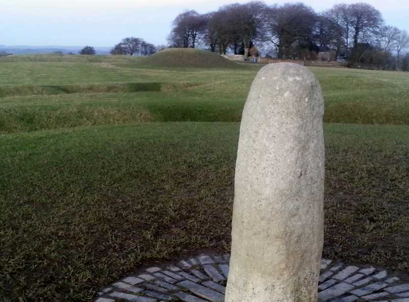
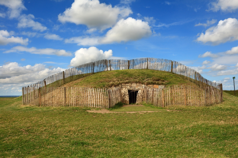
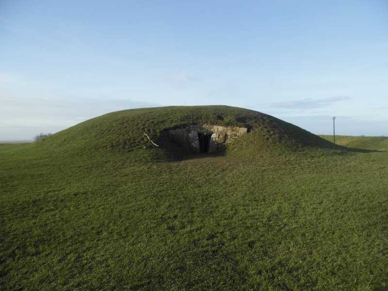
This is the most sacred of Irish hills with several ancient monuments dating back long before Christianity, some of them 6,000 years old. A full list of all the hills features can be found elsewhere online, with many of them listed in the description at the top. I would personally suggest reading up on Cormac Mac Airt (a good Meath name to this day), the mound of the hostages and also on the Lia Fail before heading out on to the hill, but I leave all this to yourself. Youtube is cluttered up with rubbish from the M3 protesters, but in amongst this is a nice short video from renowned Tara author Michael Slavin which gives a nice introduction to the hill and some of the events that it has seen. http://www.youtube.com/watch?v=lDN7yEc0JXo#t=105

From the entrance gate it is all of 300 metres to the top of mound of the hostages at N92010 59720 starA which is the highest part of the hill. From November 2011 until recently this monument was under repair and non accessible, thankfully the restrictions have now been lifted. If you visit between June and September you can check out the excellent video presentation in the visitor centre before heading off to explore the hill (highly recommended). After seeing this video I would recommend starting your explorations from the foot of the banqueting hall (if you watch the video you will see why). Site is maintained by the OPW, car park, coffee shop and toilets all on site. In Sean Boylan's days at the helm of the county team you could have found masses of marauding Meath men trampling over this hill in the dark, but you might just be safe enough to venture out these days! Linkback: https://mountainviews.ie/summit/1059/comment/15772/
Your Score: Very useful <<  >>Average
 
MountainViews.ie Picture about mountain Tara (<i>Teamhair</i>) in area North East Midlands, Ireland
Picture: The Mound Of The Hostages
Importance Beyond Its Height
by Aidy  12 Aug 2015
Although there aren't huge impressive ruins here, Tara is worth visiting for its importance in history and legend, and I felt a strange sense of significance as an Irishman to be standing on this hill. Its one of the easiest hills to summit that I've been on, and isn't very high, although the views are surprisingly extensive, (I could see the Mourne Mountains) but its impact lies elsewhere. If you had to pick one place to signify Ireland, this would be one of the main contenders. I was particularly pleased that this happened to be my 100th mountainviews summit - not a bad one to mark the occasion! Linkback: https://mountainviews.ie/summit/1059/comment/18240/
Your Score: Very useful <<  >>Average
 
MountainViews.ie Picture about mountain Tara (<i>Teamhair</i>) in area North East Midlands, Ireland
Picture: The Mound of Hostages
 
A hill for Kings
by TommyV  29 Dec 2018
A nice easy stroll to bring the family on. A cafe and facilities near the car park. Linkback: https://mountainviews.ie/summit/1059/comment/20222/
Your Score: Very useful <<  >>Average
 
(End of comment section for Tara (Teamhair).)

OSi logo OSNI/LPS logo
Some mapping:
Open Street Map
(Various variations used.)
British summit data courtesy:
Database of British & Irish Hills
(Creative Commons Licence)
MountainViews.ie, a Hill-walking Website for the island of Ireland. 2300 Summiteers, 1460 Contributors, Newsletter since 2007