This website uses cookies, which are small text files that the website puts on your device to facilitate operation. Cookies help us provide a better service to you. They are used to track general user traffic information and to help the website function properly.
Feature count in area: 31, by county: Leitrim: 22, Sligo: 10, of which 1 is in both Sligo and Leitrim,
OSI/LPS Maps: 16, 17, 25, 26
Highest Place: Truskmore 647m
Starting Places (22) in area Dartry Mountains: Aghavoghil Middle, Arroo Trail CP, Ballaghnatrillick, Ballintrillick Forest, Barrs East, Castletown, Crumpaun, Curraghan Road, Dough Mountain NW, Dough Mountain West, Drumcliff River Road, Eagles Rock, Edenbaun, Glencar Waterfall, Gleniff Horseshoe Road, Lough Cloonaquin North, Luke's Bridge, Mountain Wood, Poulveha River, Thur East, Tormore Car Park, Truskmore Transmitter Entrance
Summits & other features in area Dartry Mountains: N: Truskmore: Gortnagarn 445m, Tievebaun 611m, Truskmore 647m, Truskmore SE Cairn 631m NE: Arroo Keeloges: Aganny Top 482m, Aghalateeve 432m, Agow Top 423m, Arroo Mountain 523m, Conwal North 421m, Crocknagapple 372m, Keeloges 452m NW: Benbulbin: Annacoona Top 597m, Benbulbin 526m, Benwiskin 514m, Benwiskin South Top 508m, Kings Mountain 462m SE: Manorhamilton Hills: Ballaghnabehy Top 413m, Benbo 415m, Dough Mountain 462m, Lackagh Mountain 449m, Larkfield 305m, Naweeloge Top 441m, Thur Mountain 442m SW: Castlegal Hills: Copes Mountain 452m, Crockauns 463m, Hangmans Hill 400m, Keelogyboy Mountain 438m, Keelogyboy Mountain Far East Top 418m, Keelogyboy Mountain NE Top 435m, Keelogyboy Mountain SW Top 417m, Leean Mountain 417m
Note: this list of places may include island features such as summits, but not
islands as such.
Truskmore SE Cairn, 631mMountain
Place Rating ..
For origin of name see Truskmore County Highpoint of Leitrim and in Sligo/ Leitrim counties in Connacht province, in County Highpoint Lists, Truskmore SE Cairn is the second highest mountain in the Dartry Mountains area and the 236th highest in Ireland. Truskmore SE Cairn is the highest point in county Leitrim and also the second highest in Sligo.
Grid Reference G76314 47102,
OS 1:50k mapsheet 16 Place visited by: 347members, recently by: Krumel, chelman7, NualaB, rhw, purpleknight, Overarroo, discovering_dann, BarnabyNutt, Carolineswalsh, knightsonhikes, nolo, JordanF1, MarionP, edowling, Tuigamala
I visited this place: NO (You need to be a logged-in member for this.)
Longitude: -8.365264, Latitude: 54.372008, Easting: 176314, Northing: 347102,
Prominence: 0m, Isolation: 0.5km ITM: 576265 847101 Bedrock type: Pale orthoquartzitic sandstone, (Glenade Sandstone Formation) Notes on name: This point is included because it is the highest point in Leitrim.
Short or GPS IDs, 6 char: TrskSE, 10 char: TrskmrSECr Linkback: https://mountainviews.ie/summit/1054/
Gallery for Truskmore SE Cairn and surrounds
Summary
for Truskmore SE Cairn :
A highpoint, easy to reach from a road and with an excellent view.
Summary created by simon3
2011-02-15 09:55:00
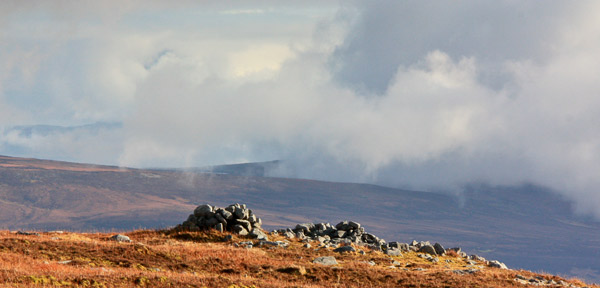
Picture: The cairn at the top of Leitrim.
The view from this summit is excellent to the NE over the area around Arroo.
The obvious way to get here is from the road up to Truskmore from which it is around 280m over low, boggy heather.
There is a limited amount of parking around Trusk Trans (G74400 46800) (access road to transmitter) and nearby.
A few years back, on a climb of Truskmore using the TV transmitter access road (due at that time to general access difficulties) at Trusk Trans (G74400 46800) I included a walk out to the SE Cairn, the highest point in Co. Leitrim. This walk,for little effort, allows anyone climbing the County Tops to include Sligo and Leitrim in the same walk. Readers might also be interested in knowing that on the way down, at the Gleniff road, a friend and myself were approached by a landowner asking us where we had been and in particular had we been on his land along the west side of the valley. We told him that we had not and got into conversation with him about access problems around the Gleniff horseshoe. As with all situations there are two sides to every story and somewhere in the middle lies the truth. After lengthy discussion about the "whys and wherefores" of the position we had a better understanding of this particular landowners difficulties. As we were leaving he told us that we would be welcome, at any time to use his land to access the Horseshoe, which we did at a later date parking, with permission, at his farmhouse. I understand that this position may have changed and that the individual may have stopped objecting to walkers using his land. Given my earlier experience I would advise that anyone using a route, other than the TV Transmitter road, should check that there are no restrictions to access currently being applied by this individual or any other landowners in Gleniff. If access is open the opportunity to do the full Horseshoe Walk starting with Benwiskin is well worth the effort. Linkback: mountainviews.ie/summit/1054/comment/4020/
Read Less
Read More
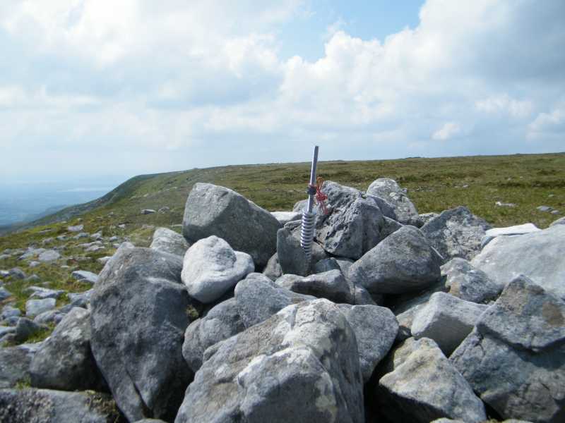
Picture: Truskmore SE Cairn
from Truskmore
by paddyobpc
24 Jan 2017
Walk Date: 05 Jun 2016. Continuing from our walk to Truskmore it was an easy and quick stroll over to Truskmore SE Cairn to say we were at the highest point of Leitrim. We returned by making our way back to the transmitter road and followed it back down to the car.
See Dillon’s (dillonkdy) full story of his County High Point Challenge at https://dillons32chpchallenge.github.io/progress/index.html We also found Kieron Gribbon's High Point Ireland website (www.highpointireland.com) to be a useful source of information for our 32 County High Points challenge. Definitely worth checking out if you're planning to do any of the High Point challenges. Linkback: mountainviews.ie/summit/1054/comment/18811/
Read Less
Read More
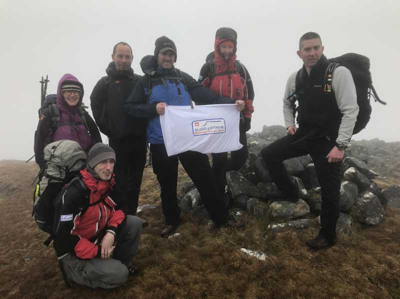
Picture: CHP 2 - Leitrim
County High Point 2018 - Leitrim
by doogleman
12 Feb 2020
Climbed 14-04-18 as part of 32 County High Point Challenge in aid of SLMRT.
This was the second of my challenge and a place I am familiar with as a Telecoms Engineer. This time however, I had to leave the vehicle at the access gate and walk up!
The access for most of the way is very straight forward, as you simply follow the RTE road until the point of turn-off to cross boggy ground to the SE Cairn. The route I took this particular day actually included going to the Sligo summit first, then navigating to the SE Cairn for the Leitrim CHP. In low visibility, it can be a bit disorientating, so if you wish you can use A (G7602 4711) as a the closest point on the road to navigate to or from the Cairn.
The Cairn is a pile of stones and clearly visible from nearby.
Note that if you are using the "PeakHunter" App to log this, its location for the Cairn is off by about 150m to the North.
Views from this point are good into the Glencar valley from 0 to 180 degrees. Linkback: mountainviews.ie/summit/1054/comment/20751/
Read Less
Read More
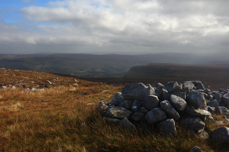
Picture: Towards the Glenade Valley On A Hazy Day
Easy County Top When On Truskmore
by Aidy
28 Sep 2015
A very short walk from Truskmore, and I was happy to take the extra summit and another county top for little effort. Worth it too for the different views across the Glenade and Glencar valleys. Felt like part of Truskmore really though. Linkback: mountainviews.ie/summit/1054/comment/18334/
Read Less
Read More
Letrim - County high point - Done with my Grandad
by ShaunDunne
18 Sep 2018
While climbing Truskmore my Grandad and I walked over and bagged our Second County high point of the day.
Was very windy and wet up there today. Linkback: mountainviews.ie/summit/1054/comment/20064/
Use of MountainViews is governed by conditions and a privacy policy.
Read general information about the site. Opinions in material here are not necessarily endorsed by MountainViews.
Hillwalking is a risk sport. Information in comments, walks, shared GPS tracks or about starting places may
not be accurate for example as regards safety or access permission. You are responsible for your safety and your permission to walk.
See the credits and list definitions.


 Our Facebook page.