Cookies.
This website uses cookies, which are small text files that the website puts on your device to facilitate operation. Cookies help us provide a better service to you. They are used to track general user traffic information and to help the website function properly.
Features
Nearby features appear when you click the map.
Declutter tracks on map.
Place Search
Video
X
Pub: by
Fermanagh & South Tyrone Area , S: Slieve Beagh Subarea
Feature count in area: 15, by county: Fermanagh: 9, Tyrone: 7, Monaghan: 1, of which 2 are in both Fermanagh and Tyrone, OSI/LPS Maps: 11, 17, 18, 19
Highest Place: Belmore Mountain 398m

Starting Places (15) in area Fermanagh & South Tyrone:
Aghanaglack, Carn Road, Carrickreagh Viewpoint, Crackrawer Road, Cullen Hill, Derrin, Dooletter, Largy S, Largy W, Lendrum Bridge Windfarm, Pollnagollum, Screggagh Windfarm, Slievemore, Tempo, Tullybrack

Summits & other features in area Fermanagh & South Tyrone:
Cen: Tempo Hills: Brougher Mountain 317m, Derrin 268m, Stranisk 312m, Topped Mountain 277m
E: Aughnacloy: Rehagy Mountain 194m
N: Largy: Largy 230m
NE: Ballygawley Hills: Cappagh Mountain 286m, Slievemore 314m
S: Slieve Beagh: Slieve Beagh 380m, Slieve Beagh SE Top 373m
W: Derrygonnelly: Belmore Mountain 398m, Cullen Hill 201m, Knockmore 277m, Legg 343m, Tullybrack 386m

Note: this list of places may include island features such as summits, but not islands as such.
Rating graphic.
Slieve Beagh SE Top, 373m Hill Sliabh Beatha (mullach thoir theas) A name in Irish,
Place Rating ..
For origin of name, see Slieve Beagh. Eshbrack an extra name in English County Highpoint of Monaghan in Ulster province, in County Highpoint Lists, Slieve Beagh SE Top is the 1011th highest place in Ireland. Slieve Beagh SE Top is the second most southerly summit in the Fermanagh & South Tyrone area. Slieve Beagh SE Top is the highest point in county Monaghan.
Grid Reference H53184 43566, OS 1:50k mapsheet 18
Place visited by: 256 members, recently by: chelman7, NualaB, rhw, oakesave, purpleknight, discovering_dann, Prem, knightsonhikes, Carolineswalsh, nolo, JordanF1, MarionP, edowling, Moirabourke, ronanmckee
I visited this place: NO (You need to be a logged-in member for this.)
Longitude: -7.183147, Latitude: 54.338031, Easting: 253184, Northing: 343566, Prominence: 5m,  Isolation: 0.8km
ITM: 653120 843566
Bedrock type: Shale, laminated carbonate, evaporite, (Meenymore Formation)

  Short or GPS IDs, 6 char: Slv373, 10 char: SlvBghSETp

Linkback: https://mountainviews.ie/summit/1053/
Gallery for Slieve Beagh SE Top (Sliabh Beatha (mullach thoir theas)) and surrounds
Summary for Slieve Beagh SE Top (Sliabh Beatha (mullach thoir theas)): County Monaghan Highpoint
Summary created by simon3, Harry Goodman 2013-10-07 09:40:54
            MountainViews.ie picture about Slieve Beagh SE Top (<em>Sliabh Beatha (mullach thoir theas)</em>)
Picture: Area of the top.
Slieve Beagh South East Top SBSET is the highpoint of Monaghan. It is a more or less unmarked hummock beside a small lake. The area is bare and wild with little steep ground.
A direct way to access Slieve Beagh SE Top is to drive to a road junction about 2.3k NE of Knockatallan at A (H571 404) and take the minor road on the left going NW to Barratitoppy Upper. If a sign still indicates that this is a road for "residents only'" confirmation has been obtained from the Knockatallon Community Centre that it is in order for walkers to drive up the road to access Slieve Beagh and Slieve Beagh SE Top.
Park carefully where a gate crosses the road at B (H554 415) about 2.3k along. When the track ahead comes to a fork, bear left and at its end head NW for 1.4k over the bleak moorland. On the way cross Pt 365 and then go on out to a small peaty hummock C (H53185 43567), Slieve Beagh SE Top, overlooking tiny Lough Sallagh. This is a desolate and bog ridden place and the need for navigational accuracy in poor visibility must be stressed. Return by way of ascent.
Another route is from the east starting at D (H562 432) where there is a small car park. Some 300m south of this an unpaved road heads NW giving 700m of good walking before the terrain becomes rough and boggy. Good navigation essential. Choose higher ground for easier underfoot conditions.
Linkback: mountainviews.ie/summit/1053/comment/5812/
Member Comments for Slieve Beagh SE Top (Sliabh Beatha (mullach thoir theas))
Comment create / edit display placeholder

SLIEVE BEAGH SE TOP FROM CARRICKNABROCK
by bsheils 23 Sep 2012
(19/09/12) Commenced walk to Slieve Beagh SE Top from pull-in point/lay-by at grid ref. D (H562 432) along minor road on Carricknabrock. Walked SSW for short distance on this road to where it meets Sliabh Beagh Way (SBW) at E (H561 428) and then following SWB I proceeded NW on gravel trackway as far as F (H558 432) where SBW turns SW direction leaving gravel track and onto bog track (note if following SBW markers the marker is obscured at this turn-off). SBW then enters area of open bogland and crosses metal bridge at G (H553 429). Due to distance between waymarkers and indistinct terrain and track care needed in poor visibility and I found the going quite soft in places. SBW appears to deviate further north from Lough Aportan than shown on map print-out that I was using and joins track that descends to T-junction at H (H545 424). Turning right at T-junction I left the SBW to follow westward bound track that contoured around side of hill to where it stopped at I (H540 425) and then proceeded NW across open mountain to find the county top.

I agree with Harry Goodman's comment that navigational accuracy is needed here especiallly in poor visibility. The day I walked here visibility was fine but I noticed hardly any significant features to assist navigation apart from the Mullaghfad Forest in distance to my left on my ascent. I approached this section of the walk by initally walking on compass bearing towards the top before referring to my GPS to hone in on grid ref for the top as per MV. However, as distance from end of last track above to top is 1.3km walking on compass bearing over this distance is not easy with virtually no distinguishing features to take bearing towards along the way. I reached county top as shown on photos by dr_banuska and Harry Goodman. It is indeed an undistinguished county top as noted by the latter contributor though another county top ticked off the list!

I returned by the same route as above that I had followed to the Sliabh Beagh SE top. Linkback: mountainviews.ie/summit/1053/comment/14821/
Read Less
Read More

            MountainViews.ie picture about Slieve Beagh SE Top (<em>Sliabh Beatha (mullach thoir theas)</em>)
Picture: A taste of Slieve Beagh
What a lovely walk, it's being under sold
by AdrianneB 6 Aug 2016
Walked to this summit today. So much nicer than I expected. I was only going to tick it off my county tops list. Followed the route as suggested by Simon3 and Harry Goodman. A few updates: there is a sign pointing up the side road for the three county hollow, along with a few waymarked walks, walkers are definitely welcome; there is a sign at the gate requesting that from April 1st to August 1st you do not walk across the heather due to ground nesting birds, which means no trip to the "summit" during these months.
It was a great day to be there, Heather in bloom, lots of fraughns for snacking on, saw a snipe, got to lie by the lake for a rest, not nearly as boggy as expected given the rain we've had, but very bouncy like being on giant bouncy castle. If your looking for big skies and solitude you couldn't find a better spot. Linkback: mountainviews.ie/summit/1053/comment/18608/
Read Less
Read More

            MountainViews.ie picture about Slieve Beagh SE Top (<em>Sliabh Beatha (mullach thoir theas)</em>)
Picture: Beast on Beagh? Animal prints next to my own bootprints...
Confusion over Summit Coordinates, & Beast on Beagh?
by wicklore 16 Apr 2010
There is definitely something odd going on with the given coordinates for Slieve Beagh SE Top. Having read three5four0’s piece on the apparent error with interest, I found myself up there this week in the pursuit of another County Top. I also followed Harry Goodman’s clear route. The coordinates I captured at the highest point of Monaghan were J (H53185 43600). I reckon this is about 100 metres south of the given MV coordinates. However having been up there I feel confident in saying that my recorded gps coordinates are fairly accurate. I feel the MV coordinates would have you teetering on the edge of Lough Sallagh, if not actually in it! Lough Sallagh is definitely lower than the mound which I considered to be the summit.

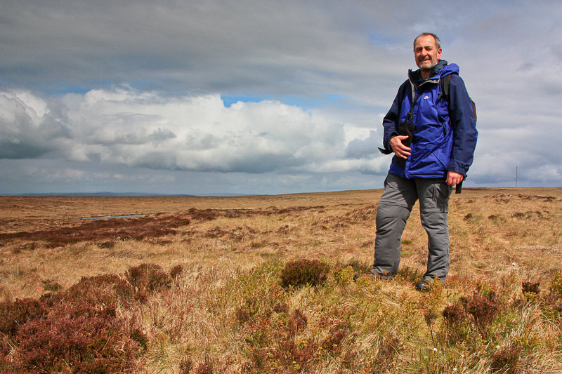
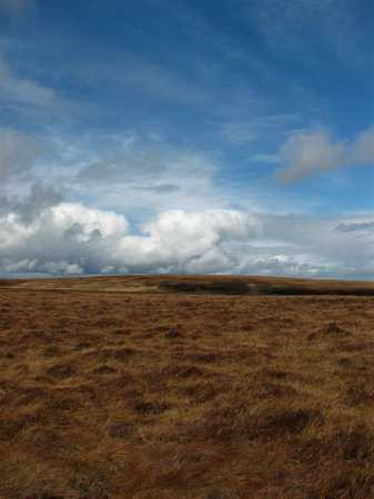
Why is accuracy important? What is 100 metres here or there? Well, as other contributors have pointed out, Slieve Beagh SE Top (and Slieve Beagh in general) is a remote, featureless, bleak expanse of undulating bog. It is beautiful in its stark nature. But it could be fierce and unforgiving to those who go there in poor visibility and who cannot navigate. 100 metres could be the difference between a successful County Top bagged or the start of an unexpected adventure lost in the wilds of Fermanagh, Tyrone and Monaghan!

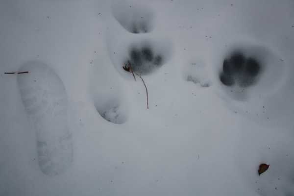
Be warned - this whole bog is wet, wet, wet! Every footstep sinks into the ground beneath the heather and grass. It must be supersaturated, and it means the effort required to trudge over the heavy ground is more than might be expected. Speaking of footsteps – I came across very large animal prints in the snow on the track leading past Lough Antraicer. They looked like giant cat prints. I took a photo with my own footprint next to them for size comparison. My wife assures me they are dog prints, and now thinks I have walked alone in the hills for long enough. But there were no other human or animal prints with the footprints. Would a lone dog be likely to walk up here by itself? Maybe I have walked alone long enough!!

Note: one week after this post an animal expert confirmed that these prints are in fact from a dog, possibly a Labrador. Big dog! Linkback: mountainviews.ie/summit/1053/comment/4599/
Read Less
Read More

            MountainViews.ie picture about Slieve Beagh SE Top (<em>Sliabh Beatha (mullach thoir theas)</em>)
Picture: Above Shane Barnagh
An undistinguished County Top
by Harry Goodman 9 Aug 2016
On a walk to Slieve Beagh (Doocarn) in July 2006 I walked out over spot height 365m shown as Eshbrack on the OSI Map Sheet 28A. I assumed this was also Slieve Beagh SE top and thought I had walked over the highest point in Monaghan. It was only after I was back home that I realised that Slieve Beagh South East Top (Eshbrack), as shown by the MV reference, was not this spot height but a small hummock some 800 metres further to the NE!! As I was doing the County Tops at the time I re-visited the area about a month later and walked out to Slieve Beagh SE Top the highest point in Monaghan. I started at a gate across a minor road at B (H554 415) and followed a track up through Barratitoppy Upper to fork then bear left. At the end of the track I went NW over spot height 365m Eshbrack and then continued over the bleak moorland to a peaty hummock which is the highest point in Co. Monaghan, overlooking little Lough Sallagh. I returned by the outward route. The moral in this tale, always check your references and do not commit to memory!!! Since first writing this comment the accuracy of the MV grid reference for this top has been questioned by wicklore and three5four0. In particular it has been pointed out that using OSNI Sheet 18 leaves the mv grid ref below the 370m contour. This certainly is the case reading Sheet but if the reference is traced on OSI Sheet 28A there is a distinct ring contour for 370m which extends further N than that on OSNI Sheet 18. Using Sheet 28A may allow the listed mv grid ref to fall just on the N tip of the contour and, I assume, allowing for a margin of error, indicate they could lie within same. As to the question of accuracy of the mv grid ref hopefully this can be checked with a GPS(s) and amended if necessary. Certainly as pointed out by wicklore an accurate reference would be necessary to find this remote and undistinguished high point in poor weather. This said, in clear conditions, the peaty hummock marking the high point is quite distinct and even the most fastidious walker would not have to tramp around too much to have satisfied her/himself that the top had been covered. Having read the 06/2010 Newsletter I am pleased to note that an accurate GPS reading, differing somewhat from the original reference, has now been posted on the site and should serve those going in search of Monaghan's highest point very well indeed, whichever map is used. Linkback: mountainviews.ie/summit/1053/comment/4003/
Read Less
Read More

            MountainViews.ie picture about Slieve Beagh SE Top (<em>Sliabh Beatha (mullach thoir theas)</em>)
Picture: Big Sky on Slieve Beagh
Slieve Beagh & S E Top
by murraynolan 30 Apr 2010
I enjoyed my walk up Slieve Beagh taking in the South East Top.

As with many of my county top walks so far, I had the mountain to myself on this showery midweek day in April.

I followed Harry Goodman's references and was quite proud of my newly learned navigation skills as I discoverd to my relief that Lough Sallagh does in fact lie just over that rump on the horizon. It really only comes into view at the last moment.

I found on the outward journey, that as the ground levels out after you have ascended for a few minutes at the end of the trail, there is a lone pine tree just to the right of the 365 spot height that serves as a good midpoint before carrying on to the SE Top which is by then visible.

The going certainly is boggy, and the surroundings and sky feel quite vast as you cross the flat expanse towards the top and Lough Sallagh. Having said that, I was accompanied by the noisy chatter of countless birds who I could hear but not see. This in stark contrast to the relative silence of the lower reaches of the hill which look and smell of an extensive recent burning. Linkback: mountainviews.ie/summit/1053/comment/4674/
Read Less
Read More
EDIT Point of Interest
text
Videos
Recent Contributions
x
Conditions and Info
Use of MountainViews is governed by conditions and a privacy policy.
Read general information about the site.
Opinions in material here are not necessarily endorsed by MountainViews.
Hillwalking is a risk sport. Information in comments, walks, shared GPS tracks or about starting places may not be accurate for example as regards safety or access permission. You are responsible for your safety and your permission to walk.
See the credits and list definitions.

OSi logo
OSNI/LPS logo
Open Street Map
(Various variations used.)
British summit data courtesy:
Database of British & Irish Hills