Cookies.
This website uses cookies, which are small text files that the website puts on your device to facilitate operation. Cookies help us provide a better service to you. They are used to track general user traffic information and to help the website function properly.
Features
Nearby features appear when you click the map.
Declutter tracks on map.
Place Search
Video
X
Pub: by
North East Midlands Area , Cen: Oldcastle Subarea
Feature count in area: 24, by county: Cavan: 7, Westmeath: 5, Meath: 5, Monaghan: 3, Leitrim: 1, Louth: 1, Longford: 2, OSI/LPS Maps: 26, 27, 27A, 28, 28A, 28B, 34, 35, 36, 41
Highest Place: Cornasaus 339m

Starting Places in area North East Midlands:

None for this area

Summits & other features in area North East Midlands:
Cen: Ballyjamesduff: Aghalion Hill 249m
Cen: Oldcastle: Mullaghmeen 258m, Slieve Na Calliagh 276m, Spire of Lloyd 131m, The Hill of Mael 241m
E: Kingscourt: Carrickleck Hill 173m
N Cen: Cavan Town: Shantemon 218m, Slieve Glah 320m, Tievenanass 261m
NE: Ballybay: Bunnanimma 268m
NE: Carrickmacross: Corduff 243m
NE: Castleblaney: Mullyash Mountain 317m
NE: Cen Bailieborough: Cornasaus 339m, Taghart South 290m
NW Cen: Arva: Bruse Hill 260m
NW: Aughavas: Lugganammer 190m
S Cen: Crookedwood: Cruckboeltane 199m, Knockeyon 214m
S: Westmeath South West: Knockastia 200m
SE: Boyne Valley: Hill of Slane 160.4m, Mount Oriel 251m, Tara 155m
W: Ardagh: Bawn Mountain 200m
W: Drumlish: Corn Hill 278m

Note: this list of places may include island features such as summits, but not islands as such.
Rating graphic.
Mullaghmeen, 258m Hill Mullach Mín A name in Irish,
Place Rating ..
(Ir. Mullach Mín [logainm.ie], 'smooth summit') County Highpoint of Westmeath in Leinster province, in County Highpoint, Binnion Lists, Mullaghmeen is the 1268th highest place in Ireland. Mullaghmeen is the highest point in county Westmeath.
Grid Reference N46924 79379, OS 1:50k mapsheet 41
Place visited by: 372 members, recently by: NualaB, rhw, claireod5, purpleknight, discovering_dann, Carolineswalsh, knightsonhikes, nolo, JordanF1, MarionP, edowling, Tuigamala, Buckz, crochie2, Moirabourke
I visited this place: NO (You need to be a logged-in member for this.)
Longitude: -7.289195, Latitude: 53.762078, Easting: 246924, Northing: 279379, Prominence: 146m,  Isolation: 3.3km
ITM: 646868 779397
Bedrock type: Undifferentiated limestone, (Visean Limestones (undifferentiated))
Notes on name: Mullaghmeen is the highest point in Co. Westmeath but, at 261m, it has the distinction of being the lowest of all the county tops in Ireland. A walk to its summit is described in Paul Clements' book The Height of Nonsense (147-53). The hill also gives name to the townland (par. Foyran) in which it is located.
  Short or GPS IDs, 6 char: Mlghmn, 10 char: Mulaghmen

Linkback: https://mountainviews.ie/summit/1050/
Gallery for Mullaghmeen (Mullach Mín) and surrounds
Summary for Mullaghmeen (Mullach Mín): Its a Beech! (forest)
Summary created by jackill 2011-01-26 13:48:02
            MountainViews.ie picture about Mullaghmeen (<em>Mullach Mín</em>)
Picture: Deja view
Turn off the country lane at A (N48160 77460) and enter a well kept Coillte forest.
Park in the large carpark. Time to complete , 1 hour .
There are 3 developed walking routes here. A variation on the Red route will get you to the summit. Follow the track to B (N47016 78953), then to C (N46758 79127) and turn right uphill to gain the treeless summit. Cross the summit and follow the track downhill to D (N47424 79131), following any of the tracks here downhill will take you back to the carpark.

Fine views from the summit across Lough Sheelin but its the airy, peaceful light of the Beech forest that makes this a truly special place.
Linkback: mountainviews.ie/summit/1050/comment/5809/
Member Comments for Mullaghmeen (Mullach Mín)
Comment create / edit display placeholder

            MountainViews.ie picture about Mullaghmeen (<em>Mullach Mín</em>)
Picture: A pleasant walk through Western Europe's largest beech forest
wicklore on Mullaghmeen
by wicklore 29 Jul 2009
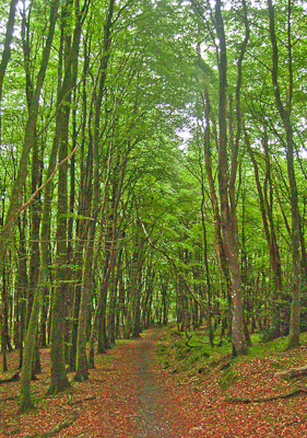
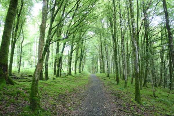
Mullaghmeen is the lowest county top in Ireland, but is situated in a vast area of forestry that includes the largest plantation of beech trees in Western Europe. The forestry alone makes this a worthwhile visit, and there are a number of historical curiosities on the hill also

You won’t find Mullaghmeen without a good map. From Dublin I headed to Mullingar, then took the R394 road to Castlepollard. From there you need to use the OS map to get to 
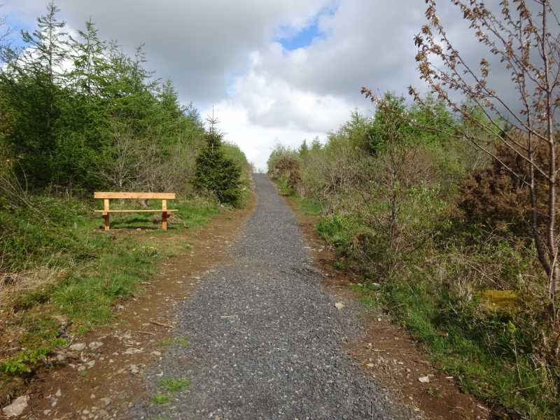
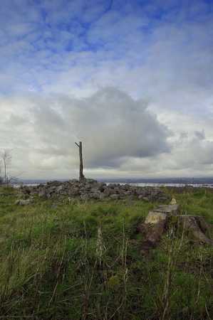
E (N489 780) and take the turn onto the minor track. This leads to a well developed car park with information boards, and a variety of colour coded walks. Follow the Red Trail for about 1 ½ km’s, and take the signpost marked ‘Cairn’. This leads to the summit, and from the car park you should be there in less than half an hour. Because there are two ‘tops’ to Mullaghmeen, make sure you are at the right one! While Mullaghmeen is covered in trees, the summit area is treeless, and gives excellent views in all directions, especially out to Lough Sheelin to the north. There is a pile of stones at the summit which I thought at first was discarded lumps of cement. However these are actually the remains of the summit cairn.

There are a variety of other things to see on your ramble around the forest. There are the remains of Flax Pits, Famine Fields, and a Booley Hut. (A Booley Hut is apparently where farmers lived on a seasonal basis while tending livestock, but I’m open to correction on this). These are all signposted and add quality to what is already a pleasant walk through the woods.
For such an out of the way hill, Mullaghmeen offers a lot more than many of its larger peers around the country. Linkback: mountainviews.ie/summit/1050/comment/3972/
Read Less
Read More

Geo on Mullaghmeen
by Geo 29 Jul 2009
Just as an additional info to wicklore's excellent comment on Mullaghmeen, you may be interested in using http://www.coillteoutdoors.ie/?id=53&rec_site=57 to get a general overview and a site map. Also on this page you can download a local map to help find your way to the forest using http://www.coillteoutdoors.ie/fileadmin/user_upload/maps/pdf/location_maps/Mullaghmeenlocmap.pdf
A lovely place for a ramble with family and /or canine friends. Linkback: mountainviews.ie/summit/1050/comment/3973/
Read Less
Read More

            MountainViews.ie picture about Mullaghmeen (<em>Mullach Mín</em>)
Picture: Towards the summit
Improved Track to and from Summit.
by TommyMc 12 May 2021
The previously muddy track on both approaches to the summit has been recently relaid with gravel, which makes for an easier and more pleasant walk than heretofore. There are also new signs forbidding horseriding, which previously damaged the earlier track.

The walk through the beech forest from the car park is an utter joy. Linkback: mountainviews.ie/summit/1050/comment/19864/
Read Less
Read More

Correction to gridref
by csd 9 May 2010
Just a quick correction to the grid ref in wicklore's comment: the turn-off is actually at F (N48156 77465). Taking the turning at the other point brings you up a rough farmer's track! Linkback: mountainviews.ie/summit/1050/comment/4695/
Read Less
Read More

            MountainViews.ie picture about Mullaghmeen (<em>Mullach Mín</em>)
Picture: The summit cairn and improvised tree-trunk marker
paulocon on Mullaghmeen
by paulocon 29 Jul 2009
Climbed this back in November 2008 as part of my 'county high points' ongoing task. Can be combined with a visit to Loughcrew in County Meath and Corn Hill in Longford, all of which are perfect for young children. As wicklore pointed out, the biggest problem is finding Mullaghmeen itself - I spent quite a bit of time being directed from Castlepollard to Oldcastle and back in my bid to find the forest park. On reaching Mullaghmeen, it's quite easy to see why it goes unnoticed - it's covered head to toe in trees and blends seamlessly into the surrounding countryside given it's lowly height of just 261 metres. Wicklore gives directions to the summit which was in an area of felled and recently replanted forest. The summit itself was marked by a scattered cairn in which was placed an elongated stump of one of the felled trees. Good views from the summit of the large expanse of Lough Sheelin. Our short stay was memorable for a conversation overheard where a chap from Dublin told his son that the hill in the distance was 'Croagh Patrick, the second highest mountain in Ireland.. I climbed it years ago.. was a beast of a thing'. When the obvious question came from his son as to which was the highest mountain, he answered 'dat's an east one dat.. everyone knows that it's the Sugarloaf'. At this point I had to nudge my daughter who was bursting to share her knowledge of mountains gleamed from her recently acquired love of mountains and hills. Linkback: mountainviews.ie/summit/1050/comment/3974/
Read Less
Read More
EDIT Point of Interest
text
Videos
(none available)
Recent Contributions
x
Conditions and Info
Use of MountainViews is governed by conditions and a privacy policy.
Read general information about the site.
Opinions in material here are not necessarily endorsed by MountainViews.
Hillwalking is a risk sport. Information in comments, walks, shared GPS tracks or about starting places may not be accurate for example as regards safety or access permission. You are responsible for your safety and your permission to walk.
See the credits and list definitions.

OSi logo
OSNI/LPS logo
Open Street Map
(Various variations used.)
British summit data courtesy:
Database of British & Irish Hills