This website uses cookies, which are small text files that the website puts on your device to facilitate operation. Cookies help us provide a better service to you. They are used to track general user traffic information and to help the website function properly.
Feature count in area: 8, all in Donegal,
OSI/LPS Maps: 1, 10, 11
Highest Place: Tievealehid 429m
Starting Places (10) in area Donegal NW: Altawinny Bay Road, An Chúirt Hotel, Cnoc Fola Carpark, Crockadillisk Bend, Crocknaneeve SouthWest, Cruit Golf Pier, Glasagh Road, Glassagh Beach, Procklis Lough, Teach Dixon
Summits & other features in area Donegal NW: N: Gweedore: Moylemore (Owey Island) 102m, Carntreena 425m, Bloody Foreland 314m, Crocknaneeve 155.9m, Tievealehid 429m S: Trawenagh: Croaghegly 245m, Trusklieve 175m W: Arranmore: Cluidaniller West Top (Aranmore) 227m
Note: this list of places may include island features such as summits, but not
islands as such.
Cluidaniller West Top, 227mHill Cnoc an Iolair (mullach thiar) A name in Irish,
Place Rating ..
(Ir. Cnoc an Iolair [An tOrdú Logainmneacha (Ceantair Ghaeltachta) 2008], 'hill of the eagle'), Donegal County in Ulster province, in Binnion, Irish Islands Lists, Cnoc an Iolair (mullach thiar) is the 1345th highest place in Ireland. Cnoc an Iolair (mullach thiar) is the most westerly summit in the Donegal NW area. Reachable "On Foot " Y Grid Reference B65427 15780,
OS 1:50k mapsheet 1 Place visited by: 28members, recently by: Wes, Geo, eejaymm, kernowclimber, mcrtchly, Fergalh, jlk, eflanaga, gerrym, simoburn, Aongus, jackill, JoHeaney, madfrankie, finkey86, Island visited by 53 members.
I visited this place: NO (You need to be a logged-in member for this.)
, I visited this island: NO
Longitude: -8.540862, Latitude: 54.988296, Easting: 165427, Northing: 415780,
Prominence: 227m, Isolation: 9.3km, Has trig pillar
ITM: 565384 915765 Bedrock type: Whitish quarztite with pebble beds, (Ards Quartzite Formation) Notes on name: The highest peak on the island of Aranmore. The anglicised form suggests an alternative name, Clúid an Iolair, 'the eagle's nook'.
Short or GPS IDs, 6 char: CldnWs, 10 char: CldnlrWstT Linkback: https://mountainviews.ie/summit/1023/
Gallery for Cluidaniller West Top (Cnoc an Iolair (mullach thiar)) and surrounds
Summary
for Cluidaniller West Top (Cnoc an Iolair (mullach thiar)):
Simple ascent, mostly on roads.
Summary created by Colin Murphy
2019-05-27 15:57:59
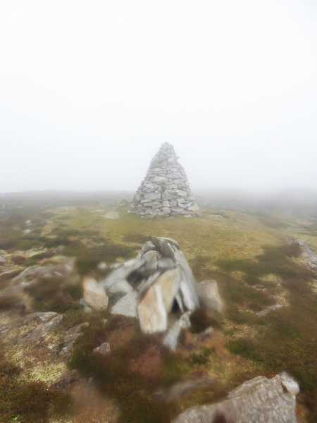
Picture: Summit cairn
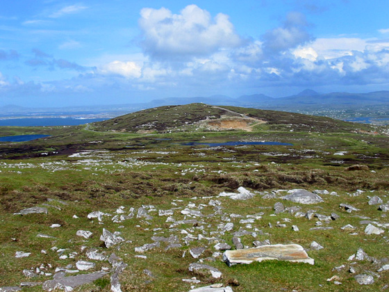
Take the ferry across from Burtonport. Whether driving or walking, take the road to the west that eventually finishes at Arranmore Lighthouse (signposted Teach Solais). At Point A (B665 169), (beside a power/communications building) turn left for about 500m. The road eventually turns into a track and you will have to leave a car behind. Follow the curving track around Cluadaniller to the SW for a couple of hundred metres and Cluadaniller West Top will be directly in front of you, about 400m to the SW. It is a gentle climb across mostly patchy heather. The summit is marked by a well-made cairn.
Irish Island Hills, Radio Hams and Callsign Controversy!
by eejaymm
3 Jul 2023
As many before we travelled over to the Island from Burtonport via the Blue Ferry. When we arrived at the port after a very pleasant run from Dungiven, there was a short wait which we used to walk the dogs then the team "packed" all the vehicles themselves so that every inch of space is used. There is a very narrow channel between smaller islands just off Burtenport that the ferry just fits through. Indeed, the company's new ferry is being specially built in Scotland as many other ferries are too wide. The clear blue skies made for amazing colours on the sea as we travelled over. One of the ferrymen kindly pointed out various landmarks on the wee islands and gave us some very unexpected information – all the major roads on the island had just been tarmaced – so all the potholed roads we had expected were not to be!
After following his instructions and getting through some very narrow junctions with the campervan we arrived at the start of the walk up to Cluidaniller West Top (Cnoc an Iolair mullach thiar). Our purpose for climbing Cluidaniller isn’t just to bag the summit but to set up a portable radio station at the summit. We are part of a program called Summits on the Air. Every Marilyn around the world can be climbed for points (10 for the highest, 1 for Arranmore) to be gained by the activators and chasers both. I am sure many of you have seen us on the hills huddled over our radio sets (recurrent theme from hillbaggers is “You won’t catch many fish up here” when they see the roach poles we use to hold the antennas up with.) A few find it interesting enough to question us closely on what we are doing and end up doing the Radio Amateur exams themselves so that they can take part.
We set off in beautiful sunshine but with a strong cool breeze. The main track goes to the East top trig, but the west top is the true summit. (Also for radio hams a dip of more than 25m makes the trig ineligible for SOTA). For half a mile there is a cart track, then head for the summit cairn over patchy heather and rocks. We set up the radio gear for HF (worldwide) and VHF (local) as we had arranged a sked with Minaun Hill on Achill on 2m (nearly 100miles). After a summit to summit with a Welch station on HF we had a chat with Phil on Achill on both VHF and UHF so success! When I finished I had made a total of 30 contacts by voice modes and morse code. We then took time for a snack and photos before heading off the hill.
A small hill with amazing views out over the Atlantic and fantastic take off for radio. 1.6k return with only 36m height to climb (20mins ascent with all our radio gear and my dodgy knees!). That evening as we sat at the monument in Lough Shore drinking a glass of wine watching the sunset there was a very interesting discussion on the SOTA reflectior about the use of EJ prefix for Irish Amateurs on Irish Islands which got very heated- suffice as to say I was just glad we chose the correct option! Linkback: mountainviews.ie/summit/1023/comment/24002/
Read Less
Read More
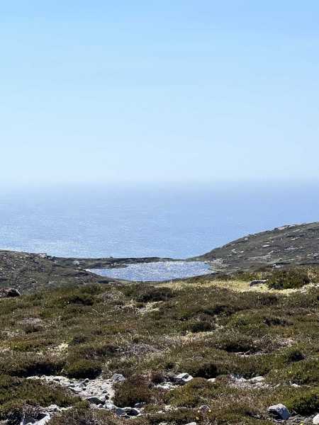
Picture: Cluidaniller and a view of the Derryveigh Mts from Cluidaniller West Top
Harry Goodman on Cluidaniller West Top
by Harry Goodman
13 Sep 2009
We took the ferry from Burtonport across to Arranmore for a day's walking on the Island. Initially we went NNW to Bellachreesh Bay before heading up over the moor to the rim of cliffs above Torneady Point. Along this cliff edge, which can be followed around to the lighthouse at Rinrawos Pt, are fine views of sea stacks. From trhe lighthouse we followed a road SE before branching off on a track S past L. Nameena and on to Cluidaniller and a trig. pillar at 226m. From here it was a short walk across past L.Namuck to Pt 227 (one metre higher!! )the highest point on the island. While unnamed on the map MV have given it the name Cluidaniller West Top. While you would not go out of your way to seek out such a modest hill the walk on Arranmore gives great purpose in doing so. Views across W to the mainland give a fine perspective of the Derryveigh Mountains. When I was there I obtained a local map which names Pt 227 (Cluidaniller West Top) as Croc na Naomh ( Hill of the Saints). From here we followed the rough track SW through Gortgarra to meet the road going NW and followed it back to the Harbour where we had started the walk. Linkback: mountainviews.ie/summit/1023/comment/4088/
Use of MountainViews is governed by conditions and a privacy policy.
Read general information about the site. Opinions in material here are not necessarily endorsed by MountainViews.
Hillwalking is a risk sport. Information in comments, walks, shared GPS tracks or about starting places may
not be accurate for example as regards safety or access permission. You are responsible for your safety and your permission to walk.
See the credits and list definitions.


 Our Facebook page.