Cookies.
This website uses cookies, which are small text files that the website puts on your device to facilitate operation. Cookies help us provide a better service to you. They are used to track general user traffic information and to help the website function properly.
Features
Nearby features appear when you click the map.
Declutter tracks on map.
Place Search
Video
X
Pub: by
West Clare Area , NE: Burren East Subarea
Feature count in area: 14, all in Clare, OSI/LPS Maps: 51, 52, 57, 58
Highest Place: Slievecallan 391m

Starting Places (16) in area West Clare:
Abbey Hill, Ballyvaughan, Ballyvelaghan Lough, Ben Dash, Derroolagh, Feenagh, Fermoyle Cottage, Glenfort, Leimaphuca, Lough Gaelan, Murroogh, Murrooghtoohy CP, Slieve Callan Wind Farm, Slieve Elva, Slievecarron, Toberkieran

Summits & other features in area West Clare:
Cen: Ennistymon Hills: Clifden Hill 189m, Knocknalarabana 204m
NE: Burren East: Abbey Hill 240m, Bouleevin 222m, Knockanes 205m, Mullagh More 180m, Slievecarran 326m
NW: Burren West: Aillwee 304m, Gleninagh Mountain 316.1m, Slieve Elva 344m
S: Ennis Hills: Ben Dash 267m, Cloontohil 190m, Slieveacurry 255m, Slievecallan 391m

Note: this list of places may include island features such as summits, but not islands as such.
Rating graphic.
Abbey Hill, 240m Hill Cnoc na Mainistreach A name in Irish,
Place Rating ..
(Ir. Cnoc na Mainistreach [logainm.ie], 'hill of the abbey'), Clare County in Munster province, in Binnion Lists, Abbey Hill is the 1303th highest place in Ireland. Abbey Hill is the most northerly summit in the West Clare area.
Grid Reference M30110 10369, OS 1:50k mapsheet 51
Place visited by: 106 members, recently by: Krzysztof_K, csd, garrettd, flynnke, Ghreallaigh, bryanmccabe, hivisibility, obrien116, melohara, marcel, BathQueen, tonibm, monisr, PabloAlto, cclair
I visited this place: NO (You need to be a logged-in member for this.)
Longitude: -9.045096, Latitude: 53.139543, Easting: 130110, Northing: 210369, Prominence: 165m,  Isolation: 5.5km
ITM: 530075 710401
Bedrock type: Bedded & massive fossiliferous limestone, (Aillwee member (lower))
Notes on name: The name refers to Corcomroe Abbey, which is located on the south side of the hill, near Bell Harbour (Bealaclugga). Walks: for a walk to the summit of Abbey Hill and around the N slopes, see Kevin Corcoran, West of Ireland Walks, 43-50, or Whilde & Simms, New Irish Walk Guide - West and North, 24-25.
  Short or GPS IDs, 6 char: AbyHl, 10 char: Abbey Hill

Linkback: https://mountainviews.ie/summit/1009/
Gallery for Abbey Hill (Cnoc na Mainistreach) and surrounds
Summary for Abbey Hill (Cnoc na Mainistreach): Straight forward ascent over limestone slabs
Summary created by jackill, Djouce 2012-07-30 08:02:25
            MountainViews.ie picture about Abbey Hill (<em>Cnoc na Mainistreach</em>)
Picture: From the road to the west
Park at AbyHl (M31208 10189) a grassy unpaved road, room on one side for 5 cars. Abbey Hill is a popular walk in North Clare. Walk west along this track to a gap in the wall on your left at A (M31111 10471) then follow rough tracks over limestone shelves to the summit marked by a cairn at a wall junction.. On a clear day there are great views to the north over Galway Bay. On the other sides it is surrounded by the bare limestone hills of the Burren.The hill is called after Corcomroe Abbey on its eastern slopes.
Linkback: mountainviews.ie/summit/1009/comment/5768/
Member Comments for Abbey Hill (Cnoc na Mainistreach)
Comment create / edit display placeholder

            MountainViews.ie picture about Abbey Hill (<em>Cnoc na Mainistreach</em>)
Picture: Oughtmama from Abbey Hill summit
route suggestions and loop walks
by fkaatje 28 Jan 2012
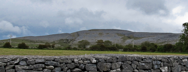
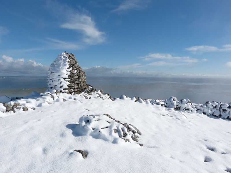
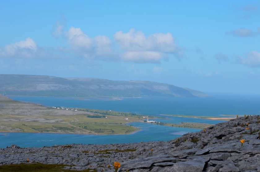
Abbey Hill is a nice short climb which rewards you with splendid views over the Burren and Galway Bay. It is also a rather popular walk and on a sunny Sunday afternoon you won’t be alone on this summit. I often take visitors from abroad up here as it is a great quick introduction to the Burren limestone landscape. The three most obvious routes are:

1. From the east. Leave the car at AbyHl (M31212 10187) and follow the green road west until a gap in the wall at B (M31107 10468). From here straight up west to the summit.

2. From the north. Either same parking as route 1, or west at St. Patricks church C (M28630 10124). Follow the green road up until a gap in the wall at 
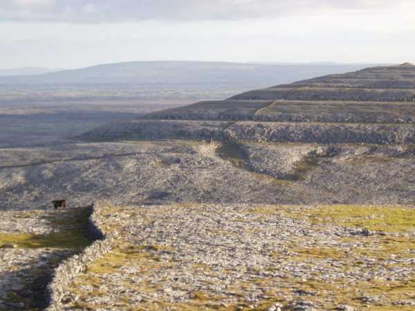
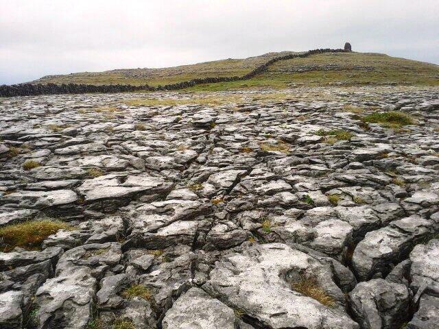
D (M30005 10878). From here follow a trail up west until you bump into the wall that will guide you all the way to the summit; first south then southeast. This route offers some easy scrambling up several small limestone cliffs.

3. From the south. Park at Corcomroe Abbey E (M29440 08935). The 13th century abbey ruins are worth the short visit. Over the wall or through the gate into the field west of the abbey. Straight up north until you meet the wall that guides you up NE all the way to the summit. This route also negotiates a few easy cliffs.

Route 1 and 2 combined give you a nice loop over Abbey Hill. For a longer loop consider taking in the nearby peaks of Oughtmama and Turlough Hill. I describe a route Bell Harbour – Turlough Hill – Oughtmama – Abbey Hill – Bell Harbour on Wikiloc (http://www.wikiloc.com/wikiloc/user.do?name=fkaatje).

As a side note: My personal opinion is that Turlough Hill offers a much better challenge than any of the West Clare summits listed on MountainViews. It’s a real pity it misses the 150m prominence criterium (the saddle connecting it to Slievecarran is just 100m lower than the summit). The same applies to other Burren peaks like Moneen and Gleninagh Mountains. Apart from offering a better challenge than the listed mountains, they are striking landmarks in the Burren; clearly distinguishable from the Salthill prom 20 km across Galway Bay. Linkback: mountainviews.ie/summit/1009/comment/6669/
Read Less
Read More

            MountainViews.ie picture about Abbey Hill (<em>Cnoc na Mainistreach</em>)
Picture: Clints and Grikes
Karst landscape at its finest
by wicklore 18 Jul 2014
The Burren is a 300 sq km region of Co. Clare which is famous for its karst landscape. This manifests itself as magnificent endless exposed limestone plateaus, rocky hills and dramatic natural clean-cut steps and stairs and blocks of rock. Beneath lie breathtaking cave systems that are still being explored. While walking on the plateaus one encounters these ‘blocks’ of rock which are called ‘clints’. The cracks or fissures between them are called ‘grikes’. These require care as the rock of the ‘clints’ can be fractured and displace, and an unplanned step into a ‘grike’ could result in a leg or foot injury.
Abbey Hill shows these clints and grikes at their finest and they allow for an entertaining ascent from the start. In places trees and tangled bushes grow out of the fissures whcih makes the descent in particular to the north very interesting in plaes! Linkback: mountainviews.ie/summit/1009/comment/17556/
Read Less
Read More

            MountainViews.ie picture about Abbey Hill (<em>Cnoc na Mainistreach</em>)
Picture: Moths on Abbey Hill
Wood Tiger Moth
by paddyhillsbagger 25 May 2022
One of the joys of scaling Abbey Hill is the abundance of flora & fauna on it's slopes.
Climbing It for the 3rd time with my brother & his daughters with their young & keen eyes uncovered an unusual looking moth hiding from the brief rain showers that befell us.
Turns out to be a Wood Tiger.
Keep your eyes open when walking. You'll never know what might be spotted. Linkback: mountainviews.ie/summit/1009/comment/23520/
Read Less
Read More

            MountainViews.ie picture about Abbey Hill (<em>Cnoc na Mainistreach</em>)
Picture: Abbey Hill Summit 09/04/2016
A snowy April morning.
by JMarc 9 Apr 2016
An easy walk close to Kinvarra. Linkback: mountainviews.ie/summit/1009/comment/18488/
Read Less
Read More

            MountainViews.ie picture about Abbey Hill (<em>Cnoc na Mainistreach</em>)
Picture: View from the top
Easy hike with the added bonus of some great scenery
by Damian120 21 Aug 2016
A nice climb that is definitely not too taxing but at the same time offering up some great scenery of the Burren. Most of the hike is over the traditional Karst limestone that this an intrinsic part of the north Clare region. Some great elevated and unique views of Corcomroe Abbey at the rear of the hill Linkback: mountainviews.ie/summit/1009/comment/18615/
Read Less
Read More
EDIT Point of Interest
text
Videos
Recent Contributions
x
Conditions and Info
Use of MountainViews is governed by conditions and a privacy policy.
Read general information about the site.
Opinions in material here are not necessarily endorsed by MountainViews.
Hillwalking is a risk sport. Information in comments, walks, shared GPS tracks or about starting places may not be accurate for example as regards safety or access permission. You are responsible for your safety and your permission to walk.
See the credits and list definitions.

OSi logo
OSNI/LPS logo
Open Street Map
(Various variations used.)
British summit data courtesy:
Database of British & Irish Hills