- Home
- Main Display
- Main Display (Old)
- Find a Walk
- Display INTRODUCTION
- DONATE
- Click below for your
profile & contributions
guestuser- New
- Tracks, Walks
- Challenge
- Community
- Lists & Logs
- Popular Lists:
- County Highpoints
- Range & Area Highpoints
- Local 100
- Highest Hundred
- Vandeleur-Lynams
- Arderins
- Carns
- Best rated
- Irish 900 up
- Irish Island
- Munros
- All Lists
- Shorter Irish
- County Highpoints
- Range & Area Highpoints
- Highest Hundred
- Local 100
- Local 100 (pre2014)
- Local Historical Cultural
- Best rated
- Irish 900 up
- Larger Irish
- Arderins
- Arderin Begs
- Arderins + Arderin Begs
- Vandeleur-Lynams
- Vandeleur-Lynams + Arderins
- Carns
- Binnions
- Highest 50 per Province
- Island Features
- Irish Island
- Coastal Hills
- Irish 600 up
- Irish 500 up
- British
- Munros
- British 600 up
- British 500-600
- British Marilyns
- Comprehensive
- All Irish summits
- All Irish features
- All British summits
- All Britain+ Ireland
- Special
- Analysis List
- Simple Irish Listings
- Simple Irish & British Listings
-
- More
- Motley Views
Welcome to MountainViews
If you want to use the website often please enrol (quick and free) at top right.Newsletters Index
Previous Newsletters
 Annual 2025
- January 2025
- Quarterly November 2024
- Quarterly August 2024
- July 2024
- Quarterly May 2024
- Annual 2024
- January 2024
- Quarterly November 2023
- October 2023
- Quarterly August 2023
- July 2023
- Quarterly May 2023
- April 2023
- Annual 2023
- January 2023
- Quarterly November 2022
- October 2022
- Quarterly August 2022
- July 2022
- Quarterly May 2022
- April 2022
- March 2022
- Annual 2022
- January 2022
- December 2021
- Quarterly November 2021
- October 2021
- September 2021
- Quarterly August 2021
- July 2021
- June 2021
- Quarterly May 2021
- March 2021
- Annual 2021
- January 2021
- December 2020
- Quarterly November 2020
- October 2020
- September 2020
- Quarterly August 2020
- June 2020
- Quarterly May 2020
- April 2020
- March 2020
- Annual 2020
- January 2020
- December 2019
- Quarterly November 2019
- October 2019
- September 2019
- Quarterly August 2019
- July 2019
- June 2019
- Quarterly May 2019
- April 2019
- March 2019
- Annual 2019
- January 2019
- December 2018
- Quarterly November 2018
- October 2018
- September 2018
- Quarterly August 2018
- July 2018
- June 2018
- Quarterly May 2018
- April 2018
- March 2018
- Annual 2018
The Summit
Monthly newsletter of MountainViews.ie for guestuser
April 2018
HILLWALKING
NEWS - INFORMATION - RECENT CONTRIBUTIONS - FEATURES - FORUMS

NORTH, SOUTH, WEST, EAST, MIDLANDS, SPAIN (Canaries), Route ideas and places to go.
Hillwalkers Winter Talks Talk about Islands of Ireland.
Sat 28th April - Galtee Meet A member is organising a meet for those interested.
Map Reviews: Wicklow South 2 maps by East-West Mapping.
Hillwalking Committee Mountaineering Ireland now has one.
2 videos featured this month. mcrtchly/kernowclimber & David Guenot,
Volunteering in 2018? We could use help on or off the committee. Some general help but also from specialists, from publicists and programmers.UPCOMING EVENTS for HILLWALKERS
MOUNTAINVIEWS: Hillwalkers' Winter Talks -
REPORT: 23rd Feb MountainViews Gathering and Awards.
Dermot Somers broadcaster and explorer spoke in his inimitable style on "CROSS-COUNTRY: A VIEW FROM ABOVE"
Mountain Meitheal
Shay Walsh, chairman, spoke on Mountain Meitheal.
There was the usual brief review of MountainViews innovation for 2017 and an Awards ceremony for list completers and contributors to hillwalking or to MountainViews.ie
Some copies of the Summit Annual are still available after the meeting. -
Weds, 11th April, 2018. 8pm. David Walsh on the Islands of Ireland
MacDara's Island, Galway
Our main speaker for this event, David Walsh, addressed Hillwalkers Winter Talks in 2015 to an audience of over 70 with a spellbinding account of visiting the islands of Ireland. Since then MountainViews.ie has with David's assistance added hundreds of islands to our pages, to a total of 577.
The Irish islands are of course a huge recreational resource for sea-kayakers, however some are reachable by walkers and their story is fascinating to anyone interested in the wild places of Ireland.
While the main speaker will be David, MountainViews will briefly introduce the changes it has made to its support for islands and also the coastline features we include. These allow users to mark which islands (as distinct from summits on islands) they have visited, to describe places, to share GPS tracks and visualise everything together on a map, features that may interest boaters or sea kayakers.
MOUNTAIN MEITHEAL: Mountain Meitheal are keen to find more people to help.
Mountain Meitheal make practical repairs to some of the more popular areas we walk on, using a voluntary community based approach. (More information at their website.)Picture of the month
Mackoght View
For original comment, click here.Photo: Member jackill took this photo of Mackoght and more on a windy day from ErrigalAn International Pic
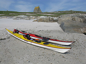
Calderón Hondo, Fuerteventura
For original track, click here.Photo: Member simon3 took this picture in Fuerteventura, Canary IslandsRegions: MOUNTAIN COMMENTS - TRIP REPORTS - TRACKS - SUMMARIES
In short: DiscoveryA Fairytale of Glenbeigh
Big walk on "premier leg-stretcher"
This month's selection is a walk stolen from Storm Emma's Baltic embrace of The Beast from the East. This climatic collision had delayed even the usually irresistible na Sléibhte juggernaut, but GSheehy was not to be deterred and went ahead to do the bulk of the Glenbeigh Horseshoe anyway. This is an itinerary often done in part, but he has done the vast majority here (only the most puritanical of purists would grumble that Seefin should have been included at the start) and added the lovely little summit of Curra Hill to the conclusion...one of Ireland's premier high-level leg stretchers. GSheehy on Glenbeigh LoopMain walk Start: 06:08, End: 14:12, Duration: 8h 4m, Length: 31.6km, Ascent: 1530m, Descent: 1279m
Places: Start at V66998 91066, Beenreagh, Macklaun, Meenteog, Coomacarrea, Mullaghnarakill, Beenmore, Drung Hill, Curra Hill, end at V65564 90448 1.6km SW from Start (statistics such as Ascent or Length etc should be regarded as approximate. Duration depends on the speed of the person making the track)
That mare of a storm ‘Emma’ played havoc with the na Sléibhte fixture for March. We had to postpone it from the first Saturday of the month, so some of us have been going down in dribs and drabs to get the walk done.
I elected for a mid-week yomp as the forecast was pretty decent. I found it hard to get accommodation in Glenbeigh this time of year. Even the ‘Open All Year Round’ place wasn’t open until the middle of the month.
Set out around six and headed for the Windy Gap. The last time I did this was anti-clockwise so It’s good to see a track from the opposite direction. You’ll definitely learn something and you’ve a whole new aspect on the views and the resulting pictures.
It was tough going with the snow up top but I was in no hurry as the rain showers stopped after about two hours.
The views lads - all the way up to the Slieve Mish on one side and the Reeks to Mullaghanattin and beyond on the other. Never mind what you're looking at on the loop itself.
It’s a crackin’ walk. I suppose if you had two cars you could do a linear to/from Mountain Stage but you’d miss the views from Curra Hill and you’d never have found out about the Fairy Forest.
Just give it a go…..
NORTH: A thing of beauty
Member jackill enjoys the rapturous beauty of Glenveagh National Park during his ascent of Kinnaveagh in the Glendowan Mountains. jackill on Kinnaveagh: Glenveagh
A photo looking down the beautiful Lough Beagh in Glenveagh national park with Kinnaveagh on the left overlooking Glenveagh castle and the Saggartnadooish ridge on the right. ... Click here ...
NORTH: Pigeon Street
To the west of the road past the Spelga Dam the Mournes become more tussocky and 'selective' in their appeal. trailtrekker has uploaded a brief excursion to the twin summits of Pigeon Rock Mountain, in itself perhaps not much more than a top ticking exercise, but it could start a more extended outing including co ck Mountain to the north, or possibly even crossing the road to complete a tough walk entirely encircling the Dam. Trailtrekker on Pigeon Rock Mountain & South Top
Despite the fact that there is minimal difference between the south top and the “main†summit of pigeon there are ve| walk, Len: 3.2km, Climb: 192m, Area: Pigeon Rock Mountain, Mourne Mountains (I ... Click here ...
NORTH: Getting high in Donegal
Black Cra does Donegal, and in particular does Errigal, and discovers the nearest thing to perfection in a hillwalk. BleckCra on Errigal, (An Earagail): Donegal a High Point
I was first introduced to Donegal 20 years ago. It was the Donegal of Buncrana, Bundoran and Ardara; of kiss me quick tourist towns, warm beer, hiked up prices and bored part time pub staff. I saw a bit of the sea and the land but in general was not much impressed by Donegal. That was pretty well the only Donegal I knew until Paddy's Day 2018 when I was introduced to real Donegal, its vast and m ... ... Click here ...
NORTH: Rock on
An updated short summary by wicklore on the fine Chimney Rock mountain in the Mournes, with multiple route suggestions. group on Chimney Rock Mountain, (Sliabh an Aoire): Fine views in the NE Mournes
Chimney Rock Mountain sits proudly above the Irish Sea in the north-eastern Mournes. Evidence of extensive mining exists along the side of the mountain at places like Carr’s Face, and the route up from the Bloody Bridge follows a mining track for a lot of its length. Five American airmen died when their B26 Marauder crashed on the mountain during training in 1944. Wreckage remains on the hill, as ... ... Click here ...
WEST: Satan's Smokestack
Amazingly your track reviewer occasionally dons footwear other than carpet slippers and emerges blinking into the open air from the safety of his Toyota. And so it was that he indulged the second greatest love of his outdoor life (namely waterfalls) on a trip westwards during some wintry weather in January. Rain and melting snow seemed unlikely to provide lovely conditions up high, so I cashed in the mental note that said 'must check out that ridiculously tall waterfall in Glencar at some point'). The falls in question are Sruth in Agaidh an Aird, slightly seasonal, but in that weather forming a gorgeous 150m mare's tail down the north wall of the glen, well worth a visit on a newly constructed path. Peter Walker on Sruth in Agaidh an Aird (The Devil's Chimney)
Noticeboard at the bottom...if you can't see this, you're somewhere elseMany have driven along the N16 to or from Sligo | walk, Len: 2.1km, Climb: 102m, Area: Dartry Mountains (Ireland) ... Click here ...
WEST: Grand slam hike!
Peter1 sacrificed the joys of watching Ireland’s Grand Slam from an armchair to traverse Tievummera in the Sheeffrys in atrocious weather – now that’s dedication! peter1 on Tievummera, (Taobh Iomaire): Super Sheeffrys
St. Patrick's Day, 2018. Halfway through this traverse I was listening to radio commentary as Ireland won a famous Grand Slam! I decided on an E-W traverse as it seems nicer to be walking towards the sea, and parked at the entrance to a wood, several kms up the valley (see route 3744). The weather conditions on the hills today were among the most challenging I've met in many years. The almost gale ... ... Click here ...
Featured summit comment
Antrim's modest Black Hill (381m) took some getting to in this aptly titled 'Against the Odds', comment in which Geansai describes the travails of being out and about in stormy conditions, of which we've had far too much in the winter just (hopefully!) gone by. Against the odds.
Geansai 22 Mar 2018
After reading about it in the Ireland Lonely Planet (LP) walking guide, did the second leg of the Antrim Hills way from the Larne- Ballymena road jump off point to Glenarm the day after the hurricane last October.
I had done the Lagan towpath from Belfast to Lisburn the previous day before things started to get out of hand in the evening with the trains not running , and just made the last bus back to Belfast at 4pm and then on to Larne before they shut everything down, by the skin of my teeth. Vicious night in Larne but it had calmed by the following morning so I got on the Ballymena bus. The driver wasn't sure where I needed to get off , luckily I correctly guessed it - a laybye on the left side of the road with a litter bin which I remember because a council guy came along in a van and emptied it. Cross the road, head back towards Larne and then at the sign for the Ulster way make your way through a very unpromising looking grassy track into the forest to emerge soon after on the open ground.
Had the whole length of the trek to myself maybe because of the hurricane hangover but only a bit of temporary mist encountered on Agnew Hill, just a few sporadic showers and the wind was fine. Some fine sunshine. Some of the waymarked posts on the first half of the walk had blown down but were still visible. One of the best walks in Ireland IMO. Started late at 11AM. This is the summit of Black hill coming up to 5PM looking southwest to Slemish about 10 miles away as the crow flies.
Still another hour and a bit to descend to the road and walk on to Glenarm. 13 miles according to LP guide though it felt like more.
SOUTH: A drop of the white stuff.
Even the most unremarkable hills are transformed by a snowfall, reports madfrankie as he ascends Slievenamon and Sheegouna in the South Midlands. madfrankie on Sheegouna, (Sí Ghamhnaí): The Tipp of the iceberg
A couple of pics from a frigid hike up Slievenamon that continued on to the NE top, Sheegouna. Amazing how even the most unremarkable hills are transformed by the white stuff. ... Click here ...
SOUTH: Cushy number
The ever-popular Cush in the Galtee Mountains is captured in brilliant spring sunshine by Simon3. simon3 on Cush, (Cois): Pictured from the SW
Cush pictured from the South West (updated 2018). Cush is surrounded by forestry to its west, south and east however to the north (right of this picture) is a long col to Galtybeg. ... Click here ...
EAST: Wintering Out
The sensible walker always has a few things up their anorak sleeve that are well suited to those damp days that seem to have come along in epidemic proportions of late. Well, now the unaware can also secrete jgfitz's walk in the Devil's Glen, a place of falling water, sculptures and Seamus Heaney tributes. It's definitely not a full day out, so those seeking more entertainment could nip north to Ballycurry. [Ed: Possibly could go to Ballycurry, but not at all clear what the access would be.] jgfitz on Devil's Glen
There is a car park within the forest at Devil's Glen, but I would recommend leaving the car at the small car park at th| walk, Len: 11.1km, Climb: 409m, Area: Dublin/Wicklow (Ireland) ... Click here ...
EAST: The madding crowds.
Lugduff SE is an enjoyable walk but a busy old hill at the weekends, discovers ewen, as he enjoys fine panoramas of Wicklow. ewen on Lugduff SE Top: Great views
A cold but sunny day ensured the boggy top and col between the top and Lugduff was frozen and firm underfoot. Did from Glenmalure lodge, following the Wicklow way. On such a clear crisp day, the Lugduffs offer great views in all directions but is quite busy. ... Click here ...
EAST: Barn noble?
Because I felt that MountainViews didn't pay nearly enough attention to rambles to bonkers buildings in muddy fields next to motorways, we're highlighting bunsen7's visit to the Wonderful Barn next to the M4 on the way out of Dublin. It doesn't really have a great deal to do with mountains or indeed views, but it's architecturally interesting bordering on insane. Somewhere definitely different if you're passing. Bunsen7 on The Wonderful Barn
A bizarrely shaped famine-era folly which has been separated from the grounds of the the nearby Castletown Estate. See a| walk, Len: 2.1km, Climb: 13m, Area: Dublin/Wicklow (Ireland) ... Click here ...
EAST: Close encounters of the hillwalking kind...
An unusual parting of the clouds gives kernowclimber the sense that he is not alone, as he ascents Wicklow’s Stoney Top. kernowclimber on Stoney Top: Close encounters of the hillwalking kind...
Arriving on Stoney Top from Tonelagge last weekend and looking across towards Table Mountain, we were suddenly sure we were 'not alone'. The sun breaking through the clouds like something from Speilburg's Close Encounters left us pretty spellbound!! ... Click here ...
MIDLANDS: Views like this don’t grow on trees
The recent felling of conifers on Corn Hill, Longford’s county highpoint, has opened up a beautiful panorama of the surrounding landscape, reports TommyMc. TommyMc on Corn Hill, (Carn Clainne Aodha): Nice Views Visible Again
I visited Corn Hill on a sunny morning in March 2018 and was pleased to see that some of the forestry that had blighted the area near summit has been felled in recent years and as a result there are fantastic views to be seen over the north Longford area into Co. Leitrim. A local walker I met nearby told me that the felled area has already been replanted with young trees. As these will grow in ... ... Click here ...
MIDLANDS: Horseplay leaves its mark.
An otherwise delightful walk up Mullaghmeen, Westmeath’s county highpoint is blighted somewhat by damage to the track from horseriders, reports TommyMc. TommyMc on Mullaghmeen, (Mullach Mín): A Delightful Walk, Muddy near Summit.
I enjoyed a delightful walk to the summit on a nippy but very sunny Sunday 25 February. Sadly the narrow track on the final approach to the summit has been cut up badly over the winter, and quite clearly worsened by someone rather inconsiderately riding a horse up and down. In its current state, it will leave you with very muddy footwear and may be a hazard for an elderly person or a young child. ... ... Click here ...
SPAIN: The Last Remake of Beau Geste
Our recovering publisher simon3 has taken another one of his holidays on one of the more temperate chunks of land adrift in the Atlantic, and amongst several tracks he's uploaded, the fun and games he went through on the walk from Femes to Playa Blanco on Lanzarote, encompassing desert, goat farms, lost maps and one of those frantic gallops for public transport that always enlivens a day. Despite all this he heartily recommends it. simon3 on Lanzarote: Femes to Playa Blanco, Minor Woes
Our original plan was perfectly simple - while on Fuerteventura climb the highest mountain. But it didn't quite work out| walk, Len: 17.3km, Climb: 250m, Area: Spain, Canary Islands () ... Click here ...
Sorry if we didn't mention what you posted .. there's a list of all contributors for recent months later.MOTLEY GATHERING
MOUNTAINVIEWS MEMBERS MEET April 2018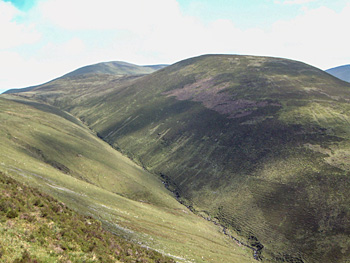 Knockaterriff.
A Mountainviews members meet is planned for Saturday 28th April 2018. Why not make a weekend of it!
The walk is open to everyone and in particular mountainviews.ie members and friends We meet on Saturday morning for a day's hike in the Galtees, perhaps the best inland range in Ireland.
Walk will be Pigeon rock Glen, up to Temple hill. Knockaterrif, Lyracappul, Carrignabinnia returning by Monabrack.
The walk is approx. 6 hours with 1000m climbing and an anticipated time of 6 hours. It will start similar to track/3427 (on www.mountainviews.ie/track/3427/) and will require a reasonable level of fitness. (Note: however unlike 3427, we will be coming down Monabrack)
A post walk meal has been booked at Cahir House Hotel for 8pm
The walk and the day are organised independently by members of mountainviews.ie and there is no charge for the walk. If you choose to donate to MountainViews you are always free to do so.
You arrange your own accommodation and any matters of insurance.
There are several accommodation options in Cahir or in the area if you prefer to be nearer the walk start.
This is a wonderful opportunity to meet members of the Mountainviews community
The walk and further details are available from Liz at elizabethashton2014@outlook.com
Lyme Disease Conference 2018Dear Sir/Madam
Let me introduce ourselves.
We are volunteers for Tick Talk Ireland ,encouraging awareness, prevention & treatment of Lyme Disease (Borreliosis) in Ireland and through Facebook bring people together to provide support through this terrible illness.
Each year we hold a conference on Lyme disease, to raise awareness and offer guidance from a range of speakers. This years event will be held on June 2nd in University College Dublin, as we are a non profit organization, Dr Lambert of Mater hospital has offered to host the event with the support of Tick Talk Ireland. The Conference is open to everyone with an interest in Lyme Disease and Chronic illness and will include presentations on using diet to combat illness and ways to promote gut health as well as information on the diagnosis and treatment of Lyme Disease.
If you have any questions please do not hesitate to contact us.
Thank you for your time.
Tick Talk Ireland
"A Tick in Time saves Lyme"
Mary/Kathy/Kerry
http://www.ticktalkireland.org/
A Hillwalking Committee for Mountaineering Ireland agreed.
The Irish Ramblers Club put in the following motion to Mountaineering Ireland (MI) for consideration at the MI meet, 24th March 2018.
The motion was passed with a unanimous show of hands.
MountainViews takes the view that this is advantageous because many of the initiatives we have taken would benefit from cooperation with bodies such as MI. An example of this is further recognition of summiteering and further support for walking lists. While we have done and can continue to develop these areas by ourselves, it is advantageous when the national governing bodies take an interest in working with us. Many of the objectives of MI such as self-reliance and land management are aided by summiteering. It would make sense to cooperate.
Board focus.
However while there is a willingness by MI to cooperate, much of the focus of the Board is on the running of what has become a substantial organisation. Were you at the meeting you would have heard the following terms from the board:
Income: Euro 1,034,746; Corporate Governance, Compliance, Statutory Requirements, Financial Probity There were three motions from the Board tightening up various aspects.
Has the MI Board lost the run of themselves? Actually not at all. It is necessary for a body funded by two governments and a membership of 13000 to run things properly. It is essential that lessons found out the hard way in various other sporting bodies are applied.
However where does this leave those interested in the actual sports - more interested in going up mountains than weighty discussions about say employment contracts. Does a board, necessarily dealing with proper governance have time to consider the sports it represents? Remember, this board is voluntary and meets perhaps 8 times a year. Who exactly is going to champion initiatives for hillwalking?
And that's hopefully where the Hillwalking Committee will come in. While it will report to the Board it will be in a position to take time to consider how aspects of the sport can be improved and developed. I recommend people do take an interest in the new committee - help it come up with agreed and useful initiatives and services with a proper long term vision. A hillwalking committee is an important step towards better support nationally & NI for the sport.
For the record, the agreed motion is as follows:
Motion:
That the Board of Mountaineering Ireland will create and support a Hillwalking Committee in recognition of the strategic importance of developing hillwalking. The Board will ensure that the committee has agreed terms of reference, support by all Mountaineering Ireland's media, coordination with clubs, support by the office and financial support.
Should any part of this motion, if passed, be in conflict or arguably in conflict with the Strategic Development Plan 2018- 2022 then, for the avoidance of doubt, the Board will ensure the plan and its actions will be amended to include the substance of the motion.
Accompanying Note:
This motion was created prior to the publication of the Strategic Development Plan 2018- 2022.
The proposers envisage a process that would include:
a) A working group of interested parties be created (not necessarily limited to the current Mountaineering Ireland membership) that will take submissions and propose an initial programme and terms of reference, and
b) We would envisage a period of several months where the terms of reference etc. are agreed.
Volunteering for 2018: Strengthening the MountainViews Committee
Currently we have a number of officers on the committee such as chairperson, secretary etc. We really could use some further committee members to achieve our strategic goals and spread the load.Position In Brief Ordinary members For those taking an interest in the MV committee or indeed committees in general we can also use some further "regular" committee members without a specific role. There are many smaller quite finite projects that might suit regular members. Publicity MountainViews is a great resource based on over 1300 people's contributions over 15 years. Great that is if you have heard of it. And that's where we could use some practical publicity help. The Geeks Shall Inherit the Earth Quite apart from programmers, would you believe MV's progress can also use help from people who can really follow through on tasks like creating lists, checking stats, researching place names or geology. Whether on the committee or not we value such people's contributions. Talks Group Not strictly speaking part of the main committee but a position involved in finding and selecting interesting speakers and organising the three events we are running each year.
Contact us at admin -at- mountainviews.ieThe MountainViews ANNUAL, 2018.

We published our third annual in Feb 2018 58 pages in 17 Articles about walking on hills, mountains and islands here and abroad.
(or Hi-res version.)
Printed copies available from www.blurb.co.uk/b/8538309-the-summit-2018emVee-Tube
Videos this month: 
Iceland jaw-droppingly presented, from members mcrtchly and kernowclimber 
A winter walk in the Sheeffry Hills, from member David-Guenot
Videography by Peter Walker.SITE NEWS
Introduction Panel You will now find an Introduction panel will appear when you start MountainViews. Hopefully it will shed light on how to get the best out of the system.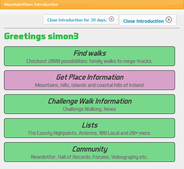
New introduction panel.
A. If you are an experienced user. Experience has taught us that even people who have been using MV for years do not always realise there are easier ways to do things. Have a look at the explanations and the detailed tutorials. You can close the introduction with a single keystroke If you are logged in you can close the introduction for 30 days at a time. Let us know if the tutorial can be improved.
B. GUESTUSER First time users have often told us the website is hard to get into. We hope this introduction will make it easier. There are short introductions to the main things you can do on this website and some longer tutorials.
You can close the introduction with a single keystroke. We would welcome feedback. You will need to create an account (very easy), login and post your suggestions in this forum.
Restarting Introduction Click on Home => Display INTRODUCTION
Thanks Thanks to magicstep for work on this introduction.
Opinions welcome at admin -at- mountainviews.ieSOSProgress on technical assistance
Another volunteer has come forward to assist us. An initial project is Handling GDPR.
We have had to bring back our SOS looking for technical support.
We now have much better facilities for volunteer software developers. To support group software development various tools are required such as Version Control, Issue Handling, Documentation Repository. We have moved our version control from an earlier tool, SVN to Git and Gitlab. Latter mentioned tool also supports issue handling and documentation.
If you wish to discuss taking a hand and have skills useful to a website such as MountainViews, get in touch (with no committment) at admin -at- mountainviews.ieCHALLENGE
A place for those interested in Challenge WalkingChallenge Walk Calendar
Challenge Walk Notes for April 2018
Knockmealdowns, a view from 2003April's Challenge Walks news sees a tale of two Cities or at least a tale of two Counties . . . well to be a correct - the tale of two great Challenge Walks as it were . . .
Unfortunate news comes to the fore, that this year will see the absence of the Mourne Seven Sevens . . .
"The main reason for this decision is the unavailability of certain key people necessary for the safe running of the event. Please remember that the whole event relies on volunteer effort.. . ."
For the last twenty-five years the Spartan Red Sox proudly hosted, with great success, a fantastic circuit Walk that would see the Challenge Walker summiting the seven highest peaks in the Mourne Mountains, all over 700 meters high. Many of the years allowed for the Walkers to decide themselves as to which direction they would traverse . . . with the Ben Crom Dam being a kind of half way mark - this meant that should one meet oncoming Walkers (coming the opposite way (their choice of direction)) a bit too early . . . then chances were, your own party were most probably enjoying the chat a little too much and would now have to "drop a gear" and pick up the pace!
This Walk also attracted a huge community of fell runners (many of whom travelled from across the Pond). Their speed at times had to be seen to be believed!
But for all concerned, it will indeed be a Calendar Date truly missed.
And yet totally over subscribed once again, is the Maumturks Challenge. . .
There are now as many would-be Walkers on the waiting list as there are Walkers who were lucky enough to secure a place within the first thirty seconds of the event going live on a third party event management website!
Other Hillwalking "host" Clubs are using this method too.
The Blackstairs Challenge sold out in a similar fashion in a little over 30 minutes.
The world of Challenge Walks is changing faster than I personally can change into a pair of dry socks after a chance encounter with a Sperrin Mountain bog hole!
April 14th is the date for the Maamturks - but a week before this, on the 7th April is the ever brilliant Knockmealdowns Crossing.
Hosted by the Peaks Mountaineering Club, this Walk has been going from strength to strength since its inaugural Walk in 2008.
Whilst the post-Walk stew and apple pie is indeed legendary - this can't be the only reason to this Walks great popularity and success. No, as has been commended before - it's the continued commitment of anything from 40 to 60 volunteers that is required for the hosting of a given Challenge Walk - but unfortunately it's a very real dilemma where, as can easily happen, the given host Club may not even have that high a compliment of members!
So again April 7th can be a date to set aside and participate in a wonderful ridge walk that sees the Walk gracefully progress over the Knockmealdowns with Knockmealdown Mountain itself being the high point of the Challenge. Being early in April, any weather is possible atop these fine hills . . . reminents of frost and even snow is very, very possible! And whether or not the sun beats down there is always a serious wind that can split a flea (or brush off the cobwebs as we Challenge Walking folk like to say!).
On to the Turks then on the 14th of the month and sure then won't we be well on our way to the blistering Irish Summer months . . !
So we are always positive within the discipline of Challenge Walking in Ireland - we have to be - this is our nature.
Early one season during one of the first years of my promotion of Challenges, something like three different Walks went by the wayside in quick succession - it felt like it would be detrimental!
Yet not long after, came the inaugural Knockmealdown Crossing (Peaks Mountaineering), then the inaugural Tom Crean Endurance Walk (Annascaul Hillwalking) and then one of toughest within the Calendar (The Triple - Fei Sheehy Challenge) . . . The rest as they say . . .
So like we continue to reiterate and always in a positive tone . . .
Onwards and Upwards,
Keep Safe and Enjoy your Day.
Jim Holmes.
Also take a look at this resource managed by MountainViews:
www.facebook.com/ChallengeWalksIrelandThis month.
Kudos to our contributors.We welcome the following new members who enrolled this month. 1958paulaDarby, alcatrazranch, Askea, Barry-Marshall, Brendamalley, B_Schiehallion, C-dog, Clive, colmmc, cowboygibbon, danielledubois, dapollard51, davemurphy53, delob10, dervla, Deyzy, DSprott, Dufay045, EGarvey, Fiola, gaelbrad, Galwaygal, Gergrylls, gerwalking, gfoxyfox, HeidiPortadown, ianmb, Jazz, Jimmy600leavey, jimsmith, Kcmountain, KenMason, Kfinn009, Knockloyd, Leigh, Libor, Marc, marcellawalking, marcinbosy, Margoanglim, Mattezekiel, Maz1234, meagher, michaelgfewer, movingturtle, muzzled2b, nickp, Norstar, Obriema, Paddy-B, Padraig-Breen, PamelaClarke, patdalton, Peter_1, Pfomeara, Power, Prendo, raymondmcevoy, ReneKrebber, RuaNua, Simschap, SmirkyQuill, Sniriain, tomlug48, twilawalking, WayneMccormack27, Wrighty1193, wtrs (68)
Our contributors to all threads this month: BleckCra (2), Bunsen7 (7), Colin Murphy (2), ColinCallanan (2), Damian120 (1), David-Guenot (6), GSheehy (1), Geo (2), IainT (3), Onzy (2), Pepe (1), Peter Walker (1), ShaunDunne (1), TommyMc (1), Wilderness (3), billbaggins (2), ckilm (1), davsheen (7), derkelly274 (3), eflanaga (1), gerrym (1), Communal summary entries (1), ianmb (1), jackill (5), liz50 (5), maclimber (1), mcrtchly (1), osullivanm (1), peter1 (2), simon3 (6), wicklore (4)
For a fuller list view Community | Recent Contributors
There were comments on the following places , Ballykildea Mountain, Bealick, Belmore Mountain, Bengorm, Binn Mhairg, Brandon Hill, Buckoogh, Camenabologue SE Top, Caunoge, Cloghernagh, Conigar, Corrigasleggaun, Croaghanmoira, Crusline, Divis, Errigal, Fananierin, Foher, Galtybeg, Great Sugar Loaf, Keelogyboy Mtn Far E Top, Keeper Hill, Kilmacomma Hill, Knockaunapeebra, Knockowen, Knockshanahullion, Lugduff, Lugnaquilla, Masatiompan, Nephin, Piaras Mór, Sceilg Mhichíl, The Playbank, Tooreenbaha
and these shared tracks Black Hill, Dublin/Wicklow Ireland, Camenabologue SE Top, Dublin/Wicklow Ireland, Cefn yr Ystrad, Llandovery to Monmouth Britain, Cooley/Gullion Ireland, Corcóg, Maamturks Ireland, Crusline, Stacks Mountains Ireland, Dublin/Wicklow Ireland, East Coast Ireland, France, Occitanie , Galtymore, Galty Mountains Ireland, Great Mell Fell, Lake District - Eastern Fells Britain, Helm Crag, Lake District - Central & Western Fells Britain, Lackabaun, Shehy/Knockboy Ireland, Lackabaun, Shehy/Knockboy Ireland, Lake District - Eastern Fells Britain, Lingmoor Fell [Lingmoor Fell - Brown How], Lake District - C Britain, Little Mell Fell, Lake District - Eastern Fells Britain, Nephin, North Mayo Ireland, Shehy/Knockboy Ireland, Shehy/Knockboy Ireland, Swarth Fell (Ullswater), Lake District - Eastern Fells Britain, The Playbank, Breifne Ireland tracks were created.
Thanks to all 1324 who have ever contributed place or routes info and forums.
For a full list view Community | Contributors Hall of Fame
Summary. MountainViews now has 8690 comments about 1634 different hills, mountains, island and coastal features out of the total in our current full list (2153). We want to get a good gps track showing each of the major ways to visit each of these places and summits in Ireland. If you see an option to add a "Short Summary" then do please consider creating one since another objective is to have a short summary for every summit and island and coastal feature in Ireland. There's a few (519) opportunities for you to be the first to comment on a summit, however lots of opportunities for islands and coastal features as we bring them out. We also have around 2000 shared GPS tracks, mostly in Ireland. Apart from a few popular areas, there is a need for more routes in many different areas. Plain shared tracks without descriptions are welcome however if you have time then do please add route descriptions with photos.NOTICES
Notices - If you are contributing, please be careful to respect the interests of landowners. Suggest access routes well away from houses, gardens or that could conceivably impact farming activities. When walking, keep away from gardens or farm buildings. Use stiles or gates wherever possible. Never do anything that could allow animals to roam where the farmer did not intend. Ask permission where appropriate.
- Take care if parking and do not obstruct roads, lanes and field entrances to access by farm machinery, which can be large. Exercise your dog in parks or forests but avoid countryside or open hillside where they may worry sheep.
- Report suspicious activity to the police forces, as below.
- If your car is broken into in an upland area report it to the PSNI or Gardai as this will help them be aware of the issue and tackle it in future. Store the numbers. In Northern Ireland use the PSNI non-emergency number 0845 600 8000. In the Republic you can find the local Garda District HQs phone numbers at www.garda.ie/Stations/Default.aspx. Specifically for the hotspot of Wicklow: the Garda Divisional Headquarters in Bray is 01 6665300.
- If you hear of a problem area or route, write it up in MountainViews
which does everyone a service.
Report rubbish tipping in the Republic - ring EPA hotline 1850 365 121
Report recreational quads in national park area (in which they are banned). They are also banned in the Mournes. For Wicklow please phone the Duty Ranger: 087-9803899 or the office during office hours Telephone: +353-404-45800. For the Mournes ring the PSNI (as above) or contact Mournes Heritage Trust. Put these numbers in your phone, take regs etc. Let MV know of contact numbers for other areas. - If you have visited some of the less well known places, we would appreciate a place rating and also "Improve Grid Ref" for summits and other places.
- If you find errors in the basic information about places such as in their names, their heights, county name etc please use the "Propose Places Database Change" option.
- If we can, let's make MV have more than one route up a summit or to a place so as to reduce the tendency for paths to appear. Your grid refs in comments for different starting points show up on MountainViews maps as well as shared GPS tracks.
-
 Visit the MountainViews Facebook page.
-
Visit the Challenge Walks Ireland page (jointly managed by MountainViews)
This newsletter
This newsletter Editor: Simon Stewart, Homepage: www.simonstewart.ie
Assistant editors: Colin Murphy, David Owens
Summit comment reviews: David Murphy
Challenge Info: Jim Holmes
Track reviews: Peter Walker
Book reviews: Aidan Dillon, Peter Walker, Mel O'Hara
Videography: Peter Walker
Graphics design advice: madfrankie
Development & support volunteers: Vanush "Misha" Paturyan, Jack Higgins, Piotr StepienNewsletter archive. View previous newsletters mountainviews.ie/newsletter RETURNING TO MOUNTAINVIEWS Click on (If you have cookies on in your browser then you will be prompted as to username/ password. If you forget the password, the login page can email you a replacement.) UNSUBSCRIBING If you don't want to receive any further monthly newsletters from Mountain Views click on Settings. Then change the option beside "Include on occasional mailing list" to "Do not include". Then click the "Save" button.
Alternatively let us know by email at admin -at- mountainviews.ie Include the email address you got this at or your screen-name guestuser.

