This website uses cookies, which are small text files that the website puts on your device to facilitate operation. Cookies help us provide a better service to you. They are used to track general user traffic information and to help the website function properly.
Feature count in area: 28, all in Mayo,
OSI/LPS Maps: 22, 23, 30, 31, CBW, EW-ACC, EW-WNN, EW-WNS
Highest Place: Slieve Carr 721m
Starting Places (24) in area Nephin Begs: Altnabrocky Adirondack Shelter, Bellanaderg Bridge, Brogan Carroll Bothy, Bunnahowna Bridge, Bunnahowna River, Burrishoole Loop, Cloondaff Church, Deel River, Furnace Lough E, Glasheens River, Glendahurk Bridge, Glennamong Bridge, LFeeagh E Treenbeg Cottage, LFeeagh E Treenbeg School Ruin, Lough Avoher Hut, Lough Feeagh, Lough Gall NW Mayo, Loughanawillan Loughs Track, Mulranny Post Office, R312 Boghadoon, R312 Prughlish, Srahduggaun, Tarsaghaunmore River, Wild Nephin Wilderness
Summits & other features in area Nephin Begs: Cen: Glennamong: Bengorm 582m, Bengorm NW Top 468m, Corranabinnia 716m, Corranabinnia SW Top 687m, Glennamong 628m, Glennamong East Top 415m, Tirkslieve 401m Cen: Nephin Beg: Aroher Hill 285m, Lettertrask 279m, Nephin Beg 627m, Nephin Beg South Top 410m E: Birreencorragh: Birreencorragh 698m, Birreencorragh South Top 564m, Birreencorragh West Top 551m, Buckoogh 588m, Bullaunmore 388m, Knockaffertagh 517m, Mount Eagle 427m, Srahmore 186m, Srahrevagh North 282m NW: Slieve Carr: Bunmore 243m, Sheeanmore 282m, Slieve Alp 329m, Slieve Carr 721m, Tawnyanruddia 531m SW: Maunthomas: Claggan Mountain NE Top 501m, Maumthomas NE Top 440m, Maumthomas SW Top 477m
Note: this list of places may include island features such as summits, but not
islands as such.
Nephin Beg South Top, 410mHill Néifinn Bheag (mullach theas) A name in Irish,
Place Rating ..
For origin of name, see Nephin Beg., Cruckgarru, Knockgorragh, Mayo County in Connacht province, in Carn Lists, Nephin Beg South Top is the 898th highest place in Ireland.
Grid Reference F93526 08250,
OS 1:50k mapsheet 31 Place visited by: 71members, recently by: Carolyn105, poopoobasto, abeach, a3642278, johncusack, glencree, elizauna, ryanguinness10, Wilderness, Wes, philmchale, markmjcampion, Michaelmangan, thrifleganger, Fergalh
I visited this place: NO (You need to be a logged-in member for this.)
Short or GPS IDs, 6 char: Nph410, 10 char: NphnBgSthT Linkback: https://mountainviews.ie/summit/784/
Gallery for Nephin Beg South Top (Néifinn Bheag (mullach theas)) and surrounds
Summary
for Nephin Beg South Top (Néifinn Bheag (mullach theas)):
Straight forward route out and back.
Summary created by Harry Goodman
2012-05-24 20:21:43
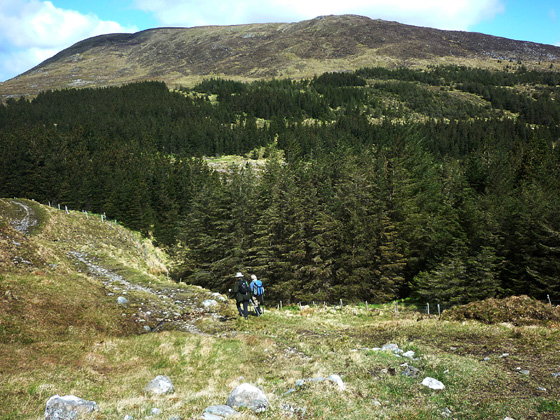
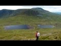
Picture: Walkers making for Nephin Beg S Top (in background) along the Bangor Trail.
Perhaps the most difficult part of this route is to find the start point! About 1k N of Newport take a minor road to the right A (F981 950) and follow it along, generally in a northerly direction for some 11k, passing L. Feeagh on the way. At B (F973 055) leave the road and go left onto an unsurfaced but good quality track. The start of the route is at the Brogan Carroll Bothy some 500m further along to the left of the track with ample parking space. Head W to cross a narrow wooden bridge and follow the way marked route of the Letterkeen Looped Walk and the Bangor Trail. Some 3.2k along, where the forest on the right is replaced by open ground C (F937 073), go directly N up the hillside to gain the top about 1k further along D (F93527 08251), on a broad flattish summit area and marked by a small pile of stones. Return by way of ascent. It is unlikely that this top will be climbed very often in it's own right. More likely it will be used as a point of reference for a climb of Nephin Beg.
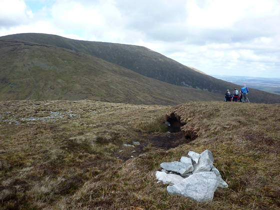
Picture: Walkers on the S Top making for Nephin Beg
A way to better things.
by Harry Goodman
24 May 2012
Climbed this top on 8 May 2012 as part of a round that also included Nephin Beg. A constant thought that one has in climbing in this range for the first time is one of "remoteness". Even finding the start point for a walk can be difficult to locate among the numerous small roads and lanes that abound in this part of Mayo. We parked at the Brogan Carroll stone bothy E (F968 055) and followed the waymarkers W for the Letterkeen Looped Walk/Bangor Trail. After initially crossing a narrow wooden bridge over the Altaconey River we followed the trail for some 3.2K to C (F937 073) a point where the forest on the right ends, to be replaced by open ground. The S Top lay due N up the hillside 1k along and some 230 metres in height gain. Going was good and the climb gradual, over a mix of grass and peat with occasional stoney patches. While the view N from the top is dominated by Nephin Beg there were fine views SW to Glenamong and the mountains of the Corranbinna Horseshoe, with Bengorm, our climb on the previous day clearly visable due south. Nephin Beg S Top is a broad flatish non-descript area with the high point marked by a small pile of stones. Return is by way of ascent or for a more satisfying day in the hills, as in our case, continue on NNW to Nephin Beg about 2.2k further along. Linkback: mountainviews.ie/summit/784/comment/6816/
Read Less
Read More
Following the Bangor Trail(ish)
by Geo
25 Jul 2010
Did this on the way to Slieve Carr on 24 07 10. Started by parking at Letterkeen Wood at F (F97658 05083). Walked South for a couple hundred metres then followed the Western Way/Bangor Trail markers to the right and then on to the bothy where there's an info board describing the Letterkeen Loop/Western Way/Bangor Trail on which you are on all three at this point. We went across the very sturdy bridge and followed the Bangor trail west on a rough track until we came to a junction where the Bangor Trail continues forward and the Letterkeen Loop goes right. At this point we followed the Trail straight ahead for about 200metres passing the corner of the forest then went right off the trail and followed a bearing for the summit uphill. Two hours from the car and a small pile of stones seems to mark the possible summit although I took my GPS reading some 20metres away where the highest point (it seemed) was! We had no views as the cloud surrounded us and the Atlantic was hellbent on making sure we were soaked in the drizzle/mist. Linkback: mountainviews.ie/summit/784/comment/5969/
Use of MountainViews is governed by conditions and a privacy policy.
Read general information about the site. Opinions in material here are not necessarily endorsed by MountainViews.
Hillwalking is a risk sport. Information in comments, walks, shared GPS tracks or about starting places may
not be accurate for example as regards safety or access permission. You are responsible for your safety and your permission to walk.
See the credits and list definitions.


 Our Facebook page.