Cookies.
This website uses cookies, which are small text files that the website puts on your device to facilitate operation. Cookies help us provide a better service to you. They are used to track general user traffic information and to help the website function properly.
Features
Nearby features appear when you click the map.
Declutter tracks on map.
Place Search
Video
X
Pub: by
Wicklow Area , NE: Vartry Subarea
Feature count in area: 115, by county: Wicklow: 108, Kildare: 4, Wexford: 2, Carlow: 3, of which 1 is in both Wexford and Wicklow, of which 1 is in both Carlow and Wicklow, OSI/LPS Maps: 28B, 55, 56, 61, 62, AWW, EW-DM, EW-LG, EW-WE, EW-WS
Highest Place: Lugnaquilla 924.7m

Starting Places (205) in area Wicklow:
1916 Memorial Car Park, Aghavannagh Ow Bridge, Aghowle Wood, Altidore Wood Entrance, Annacurra National School, Annalecka Bridge, Asbawn Brook L8350, Aughrim National School, Ballard Road, Ballinabarny Gap, Ballinagappoge Bridge Layby, Ballinagappoge Mountain Hairpin, Ballinagore, Ballinahinch Wood, Ballinastoe MBT CP, Ballinastraw South, Ballineddan Upr Fork, Ballinfoyle Upr Cross, Ballycoog, Ballycreen Brook Bridge, Ballycumber, Ballycumber Bridge, Ballycumber Lane, Ballycumber Wicklow Way, Ballylerane, Ballylow Bridge, Ballylusk Quarry, Ballymanus Lane, Ballymoyle Shooting Lodge, Ballynultagh Gap, Ballynultagh Lane, Ballyreagh Wood, Ballyross Forest, Ballysmuttan Long Stone, Baravore, Barnbawn South, Barranisky North, Barranisky West, Bohilla Land Roundabout, Bohilla Lane Mid, Boranaraltry Bridge, Bray Harbour, Brewel West, Brittas Bay North CP, Buckroney Sand Dunes CP, Bus Terminus, Camera Hill Track Cross, Castletimon Wood North, Clara Vale, Clone House Road, Clonegal, Cloon Wood Cp, Coate Bridge, Coolballintaggart Ledge, Coolbawn House Lane, Cransillagh Brook , Crone Wood CP, Crossbridge, Crossoona Rath, Cummer Wood South, Curtlestown Wood CP, Deputy's Pass CP, Derralossary Church, Derry River Bridge, Devil's Glen CP, Devil's Glen Wood, Djouce Wood Calary, Djouce Wood Lake, Djouce Wood Long Hill, Donard, Donnelly's Lane Car Sales, Drumgoff Forest, Dunranhill North, Dunranhill SE, Dunranhill South, Dwyer McAllister Cottage CP, Enniskerry, Fentons Pub, Fitzsimons Park GAA, unuseableFlemings Footbridge Glen Rd, Gap Pub, Gap Road, Glen Beach CP, Glen of the Downs CP, Glenbride Lane, Glenbride Lodge, Glencree Reconciliation, Glendalough, Glenealy GAA, Glenmacnass Tonelagee CP, Glenmalure Hostel, Glenmalure Lodge, Glenmalure Waterfall, Glenview Hotel, Gowle House, Great Sugar Loaf CP, Grove Bar, Heffernans Well Wood, Hill View, Hollywood Glen, JB Malone CP, Johnnie Fox Pub, Keadeen NE trail, Keadeen Trailhead, Kevins Way Footbridge, Kilbride Army Camp Entrance, Kilcandra South, Kilcommon View, Killalongford Wood, Kilmacrea Cross Roads, Kilranelagh House Gate, Kilruddery Car Park, Kilruddery Cottages, Kings River, Kippure Bridge, Kippure Estate, Kippure Transmitter Gate, Knickeen Cross, Knocknaboley Lane Leeraghs Bog, Knocknaboley Lane Stone Cottage, Knockrath Little, Knockree west, Kyle Loop North, Lackan Wood S, Lake Dr Fraughan Brook, Lake Drive, Lake Park Cross, Lake View Pub, Laragh Free Car Park, Laragh NSch, Lead Mines CP, Liffey Bridge, Liffey Head Bridge, Lough Bray Lower, Lough Bray Upper, Lough Tay North Viewing Point, Lough Tay Wicklow Way CP, Luglass Lane L97561, Lugnagun Track, Macreddin Village, Mangans Lane, Military Road Carrigshouk Hill, Military Road Inchavore River Nth, Military Road Inchavore River Sth, Military Road NW Lough Tay, Military Road Ballyboy Bridge, Military Road Cloghoge Brook, Military Road Croaghanmoira, Military Road Fananierin, Military Road LaraghWicklow Way, Military Road Slieve Maan, Monspolien Bridge, Moortown House, Mountain Rescue HQ, Muskeagh Little Wood, Nahanagan Lough NE, Novara Avenue, Bray, Oiltiagh Brook Knickeen, Old Bridge Cross, Old Bridge Scouts , Old Wicklow Way entrance, Paddock Hill SE, Pier Gates CP, Powerscourt Waterfall CP, Putland Road, Quintagh East, Raheen Park CP, Raheenleagh East, Railway Walk CP, Rathdrum Railway Station, Rednagh Wood, Rocky Valley, Roundwood, Sally Gap, Sally Gap N, Seefin Trailhead, Seskin SE, Shankill Tributary Bridge, Shay Elliott, Sheepshanks Bridge, Shillelagh, Slievecorragh Track, Slievefoore South, Sraghoe Brook, St John's Church, St Kevins Chair, St Kevins Church, St Kevins Way R756, Stone Circle Bridge, Stookeen South, Stranahely Wood, Stranakelly Cross Roads, Tallyho, Templeboden, Tithewer, Tomcoyle Lower, Tomriland Wood, Toor Brook, Trooperstown Hill Access, Turlough Hill CP, Upper Lake CP, Vallymount GAA CP, Vartry Reservoir Upper, Zellers Pub

Summits & other features in area Wicklow:
Cen: Glendalough North: Brockagh Mountain 556.9m, Brockagh Mountain NW Top 549.5m, Brockagh Mountain SE Top 471.7m, Camaderry East Top 677.3m, Camaderry Mountain 698.6m, Conavalla 734m, Tomaneena 682.4m
Cen: Glendalough South: Carriglineen Mountain 456.6m, Cullentragh Mountain 510m, Derrybawn Mountain 476.1m, Kirikee Mountain 474.5m, Lugduff 653.2m, Lugduff SE Top 638m, Mullacor 660.7m, Trooperstown Hill 430m
N Cen: Tonelagee: Carrignagunneen 561m, Fair Mountain 571.2m, Stoney Top 713.7m, Tonelagee 815.8m, Tonelagee E Top 668m, Tonelagee South-East Top 545.8m
NE: Bray & Kilmacanogue: Bray Head Hill 238.9m, Carrigoona Commons East 242m, Downs Hill 372.9m, Great Sugar Loaf 501.2m, Little Sugar Loaf 342.4m
NE: Djouce: Djouce 725.5m, Knockree 342.1m, Maulin 570m, Tonduff 642m, Tonduff East Top 593m, War Hill 684.8m, White Hill 631.1m
NE: Fancy: Ballinafunshoge 480m, Kanturk 527.4m, Knocknacloghoge 532.4m, Luggala 593.3m, Robber's Pass Hill 508.9m, Scarr 640m, Scarr North-West Top 559.8m, Sleamaine 430m
NE: Vartry: Ballinacorbeg 336m, Ballycurry 301m, Dunranhill 342m, Mount Kennedy 365.9m
NW: Blessington: Carrigleitrim 408m, Lugnagun 446.2m, Slieveroe 332m, Sorrel Hill 599.5m
NW: Mullaghcleevaun: Black Hill 602.2m, Carrigshouk 572.5m, Carrigvore 682.4m, Duff Hill 720.8m, Gravale 719m, Moanbane 703m, Mullaghcleevaun 846.7m, Mullaghcleevaun East Top 796m, Silsean 698m
S: Aughrim Hills: Cushbawn 400m, Killeagh 249m, Moneyteige North 427m, Preban Hill 389m
S: Croaghanmoira: Ballinacor Mountain 529.3m, Ballycurragh Hill 536m, Ballyteige 447m, Carrickashane Mountain 508m, Croaghanmoira 662.3m, Croaghanmoira North Top 579.5m, Fananierin 426m, Slieve Maan 547.8m, Slieve Maan North Top 546.1m
S: Croghan Kinsella: Annagh Hill 454m, Croghan Kinsella 606m, Croghan Kinsella East Top 562.1m, Slievefoore 414m
S: Shillelagh Hills: Lakeen 357m, Monaughrim 206m, Seskin 344m, Stookeen 420m
S: Tinahely Hills: Ballycumber Hill 429.7m, Eagle Hill 296m, Muskeagh Hill 398.2m
SE: Wicklow South East: Ballinastraw 284m, Ballyguile Hill 188m, Barranisky 280m, Carrick Mountain 381m, Collon Hill 238m, Kilnamanagh Hill 217m, Westaston Hill 270m
W: Baltinglass: Ballyhook Hill 288m, Baltinglass Hill 382m, Carrig Mountain 571m, Carrigeen Hill 298m, Cloghnagaune 385m, Corballis Hill 258m, Keadeen Mountain 653m, Spinans Hill 409m, Spinans Hill SE Top 400m, Tinoran Hill 312m
W: Cen Lugnaquilla: Ballineddan Mountain 652.3m, Benleagh 689m, Camenabologue 758m, Camenabologue SE Top 663m, Cloghernagh 800m, Corrigasleggaun 794.6m, Lugnaquilla 924.7m, Slievemaan 759.7m
W: Donard: Brewel Hill 222m, Church Mountain 544m, Corriebracks 531m, Lobawn 636m, Slievecorragh 418m, Sugarloaf 552m, Table Mountain 701.7m, Table Mountain West Top 563m

Note: this list of places may include island features such as summits, but not islands as such.
Rating graphic.
Mount Kennedy, 365.9m Hill
Place Rating ..
, Ballinahinch Hill, Wicklow County in Leinster province, in Binnion Lists, Mount Kennedy is the 1027th highest place in Ireland.
Grid Reference O24244 04658, OS 1:50k mapsheet 56
Place visited by: 50 members, recently by: lauracardiff, hibby, michaelseaver, NualaB, nupat, childminder05, Dee68, Ansarlodge, Beti13, Grumbler, emac, melohara, abcd, briankelly, pinchy
I visited this place: NO (You need to be a logged-in member for this.)
Longitude: -6.146773, Latitude: 53.078382, Easting: 324245, Northing: 204659, Prominence: 138m,  Isolation: 3.1km
ITM: 724166 704691
Bedrock type: Greywacke & quartzite, (Bray Head Formation)

  Short or GPS IDs, 6 char: MntKnd, 10 char: MntKndy

Linkback: https://mountainviews.ie/summit/1085/
Gallery for Mount Kennedy and surrounds
Summary for Mount Kennedy : Rarely frequented, undistinguished forested summit
Summary created by simon3, mcrtchly 2014-05-18 09:22:14
            MountainViews.ie picture about Mount Kennedy
Picture: The summit area.
One way of reaching the top uses forest tracks from the west, starting at B'hinch Wd (O2276 0476). Follow the tracks broadly easterly until you reach A (O2402 0478) where you will be on track at the side of the forest heading gradually upwards. Ignoring turnings on the left the track narrows to a path after about 1km. When you come to a fork in the path turn left and the path curves northwards and then eastwards again to meet a wall at the edge of the forest. Turn right here and follow the forest boundary to the summit. The later part of this follows a ride between two forest blocks but beware of barb wire on the ground.

An alternative access is from the north starting at B (O2385 0578) at a gate and follow the track which passes though part of a golf course. This meets the same forest road from the west after 600m. Turn left here and follow the route as above.

The summit is probably the high point of a clearing near and east of the wall.

This mountain is little used though there were signs of occasional use by horses, runners and mountain bikers. The trees obscure much of the view at the top. Time to reach the summit and return is about 1h20 from the east and 1hr from the west.
Linkback: mountainviews.ie/summit/1085/comment/15329/
Member Comments for Mount Kennedy
Comment create / edit display placeholder

            MountainViews.ie picture about Mount Kennedy
Picture: View from near the summit of Mount Kennedy
New Red kites in the blue sky
by hibby 5 May 2024
In hopes of finding a clear route to the summit, we approached from the south, starting at Callow Hill car park C (O24995 03010).

We followed the forest roads and tracks up to about the 300 metre contour at 
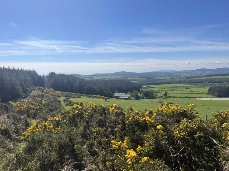
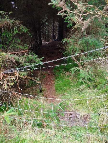
D (O24282 04031) where the path continued as a grassy track. Shortly afterwards the views opened out to the west. To our left (west) was a field with ponies grazing and a wire fence separating the field from the path. To the right was dense conifer forest. The path itself has some gorse growth but is passable.

It was clear that the path we were on would not lead us to the summit, instead bypassing the summit about 150m to the west. We were on the lookout for a firebreak or ride that would allow us to make our way through the forest. At E (O24135 04530) we saw our best chance - a deer track leading into the trees on our right. It proved easy enough to push through the trees and after about 50 metres we emerged into sunlight. From there, the final 90 metres to the summit was relatively open and clear.

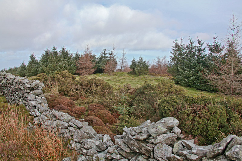
At the summit area, we identified a pile of rocks at F (O24204 04614) as the local high point.

We looked for possible alternative routes off the summit but couldn't find a better option than the way we had come up.

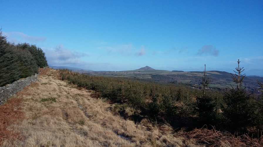
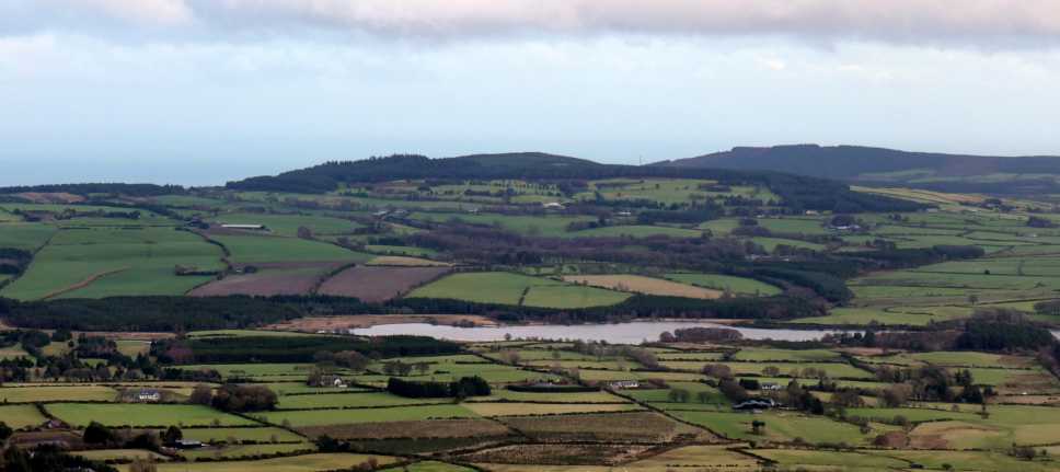
The route was almost entirely dry and firm underfoot, with the exception of a short (and easily avoided) muddy section at about the 300m contour. Views were spectacular - to the east (Dunranhill and the coast up to Bray and the Sugarloaf) in the early part of the walk and then to the west (central Wicklow mountains down to Turlough Hill) near the summit. At the summit itself, the views are mainly obscured by trees.

We were treated to excellent views of a pair of red kites on the way up. It was a breathtaking sight as they hovered right overhead, wings spread against a clear blue sky. One of them even landed and perched briefly in a tree just 20 or 30 metres away from where we were walking. The sight of the characteristic patterns of the kite, wings spread against a clear blue sky, was breathtaking.

The sound of birdsong, especially blackbirds singing their heads off, added to the summer feeling.

So, a successful expedition all in all, attaining the summit more easily than we had expected, even if we didn't find the elusive (and probably non-existent) clear route. 6 km, 2 hours car to car. Linkback: mountainviews.ie/summit/1085/comment/24191/
Read Less
Read More

            MountainViews.ie picture about Mount Kennedy
Picture: View north east from area north of the summit
Find the wall going north to south (or vice versa) over the summit
by Bunsen7 11 Feb 2018
I had to laugh when I looked at the tracks on the site and compared it to my own from B'hinch Wd (O2276 0476). If I were to upload it there would be three tracks all of which reached the summit but took an unnecessary detour to the west. I wasn't laughing while I was there admittedly, but don't look back in anger, they seem to say.

I think the reason for this detour is the track marked on the east-west map, which most observers will expect to provide some route towards the summit, but which does not. It is more like an overgrown forest ride with thick gorse, and leads you onto the west side of the forestry from which any access route back towards the summit is heavily overgrown or completely blocked (by said forestry).

The key to accessing the summit is the wall which is only very faintly shown on the East-West Mapping Wicklow Mountains East map. You'll need your spectacles to spot it. It travels roughly from north to south, dissecting the summit, with thick forestry on both sides of it, preventing access from the east or west. The wall obviously pre-dated the plantation. The 2-3 metres either side of the wall are as good a track as you'll find to this summit.

The views east and north from the area to the north of the summit which is devoid of forestry are good. Linkback: mountainviews.ie/summit/1085/comment/19854/
Read Less
Read More

            MountainViews.ie picture about Mount Kennedy
Picture: Camp fire remains at summit.
Must be an easier way.
by paddyhillsbagger 6 Aug 2015
Climbed this top in Aug 15 from point B (O2385 0578) and followed route in Short Summary. The going was very overgrown in places and a bit of a bash to get to the top. There must be an easier route however - judging from the fire and booze remains at the summit. I don't think drunk teenagers do forest bashing! Linkback: mountainviews.ie/summit/1085/comment/18231/
Read Less
Read More

            MountainViews.ie picture about Mount Kennedy
Picture: Mountkennedy
Viewed from Ballinastoe
by ceadeile 29 Dec 2022
Mount Kennedy viewed from Ballinastoe Linkback: mountainviews.ie/summit/1085/comment/23778/
Read Less
Read More

            MountainViews.ie picture about Mount Kennedy
Picture: Into forest at O 24165 04945
Getting a bit more difficult for Baggers but this worked!
by nupat 30 Mar 2024
We started from the West side at B'hinch Wd (O22782 04773) but used a critical piece of the track MV2506 (mcrtchly) who started from the North at T'hewer (O23731 05861). This resulted in easily reaching the wall mentioned by many at G (O44060 05182). We then followed the wall on a broad track between forestry. The final section is a bit more challenging due to overgrown gorse. Being March we were luckily wearing heavy winter clothes so could "push through" a few short, more difficult sections. Other contributors appear to have followed the wall all the way to the summit - however we deviated marginally to the left and this made life easier. At H (O24165 04945) we passed through a fence (already well used - picture) and veered left into the forest on a fairly obvious path; easier than continuing along the wall due to gorse. At I (O24212 04727) we returned to the wall though an already cut section of fence. Pushing through a bit of gorse here and there we reached the summit. Nice clearing but no views! Baggers only. Comments already on the site are some years old - so it appears to us that this final section of track has become more overgrown in recent years. Do it soon! Linkback: mountainviews.ie/summit/1085/comment/24162/
Read Less
Read More
EDIT Point of Interest
text
Videos


Recent Contributions
x
Conditions and Info
Use of MountainViews is governed by conditions and a privacy policy.
Read general information about the site.
Opinions in material here are not necessarily endorsed by MountainViews.
Hillwalking is a risk sport. Information in comments, walks, shared GPS tracks or about starting places may not be accurate for example as regards safety or access permission. You are responsible for your safety and your permission to walk.
See the credits and list definitions.

OSi logo
OSNI/LPS logo
Open Street Map
(Various variations used.)
British summit data courtesy:
Database of British & Irish Hills