This website uses cookies, which are small text files that the website puts on your device to facilitate operation. Cookies help us provide a better service to you. They are used to track general user traffic information and to help the website function properly.
Feature count in area: 31, by county: Leitrim: 22, Sligo: 10, of which 1 is in both Sligo and Leitrim,
OSI/LPS Maps: 16, 17, 25, 26
Highest Place: Truskmore 647m
Starting Places (22) in area Dartry Mountains: Aghavoghil Middle, Arroo Trail CP, Ballaghnatrillick, Ballintrillick Forest, Barrs East, Castletown, Crumpaun, Curraghan Road, Dough Mountain NW, Dough Mountain West, Drumcliff River Road, Eagles Rock, Edenbaun, Glencar Waterfall, Gleniff Horseshoe Road, Lough Cloonaquin North, Luke's Bridge, Mountain Wood, Poulveha River, Thur East, Tormore Car Park, Truskmore Transmitter Entrance
Summits & other features in area Dartry Mountains: N: Truskmore: Gortnagarn 445m, Tievebaun 611m, Truskmore 647m, Truskmore SE Cairn 631m NE: Arroo Keeloges: Aganny Top 482m, Aghalateeve 432m, Agow Top 423m, Arroo Mountain 523m, Conwal North 421m, Crocknagapple 372m, Keeloges 452m NW: Benbulbin: Annacoona Top 597m, Benbulbin 526m, Benwiskin 514m, Benwiskin South Top 508m, Kings Mountain 462m SE: Manorhamilton Hills: Ballaghnabehy Top 413m, Benbo 415m, Dough Mountain 462m, Lackagh Mountain 449m, Larkfield 305m, Naweeloge Top 441m, Thur Mountain 442m SW: Castlegal Hills: Copes Mountain 452m, Crockauns 463m, Hangmans Hill 400m, Keelogyboy Mountain 438m, Keelogyboy Mountain Far East Top 418m, Keelogyboy Mountain NE Top 435m, Keelogyboy Mountain SW Top 417m, Leean Mountain 417m
Note: this list of places may include island features such as summits, but not
islands as such.
Keelogyboy Mountain, 438mHill Sliabh na gCaológ Buí A name in Irish,
Place Rating ..
, Sligo County in Connacht province, in Carn Lists, Keelogyboy Mountain is the 778th highest place in Ireland.
Grid Reference G77114 39048,
OS 1:50k mapsheet 16 Place visited by: 67members, recently by: eimirmaguire, chelman7, andalucia, Peter Walker, finkey86, oreills8, Carolyn105, abeach, melohara, noucamp, magnumpig, LorraineG60, MichaelG55, pmeldrum, rollingwave
I visited this place: NO (You need to be a logged-in member for this.)
Short or GPS IDs, 6 char: KlgyMn, 10 char: KlgybyMntn Linkback: https://mountainviews.ie/summit/665/
Gallery for Keelogyboy Mountain (Sliabh na gCaológ Buí) and surrounds
Summary
for Keelogyboy Mountain (Sliabh na gCaológ Buí):
Some cliffy interesting sides with a boggy top.
Summary created by simon3
2010-06-29 21:31:41
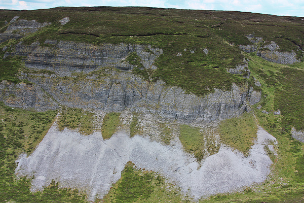
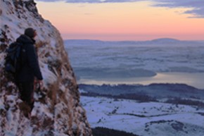
Picture: Southern side of Keelogyboy Mountain from SW Top.
The west and south west sides of Keelogyboy Mtn have some interesting cliffs however the summit area itself is the least interesting of the Keelogyboys, being covered in peat hags.
The summit can be accessed from the public road to the west at A (G7567 4001).
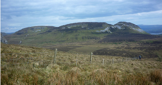
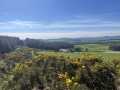
Picture: Keelogyboy NE Top, Keelogyboy Mt. and Keelogyboy SW Top as seen from Cope's Mt.
The first of six.
by Harry Goodman
26 May 2012
I climbed this hill on 5 May 2012 as the first top in a round of six mv listed hills. To reach the start of our walk we left the N56 from Sligo to Manorhamilton at B (G721 395) and followed a minor road E for some 4.5k to C (G76269 40300) where there was room to park to the side of the road. We initially walked E then SE for some 400m to the end of the road by which time it had become an unsurfaced gravel track. Keeping left at a fork we made our way SE passing an old ruined farm on our right before crossing a stream. Keeping the stream on our left we made for the dip between Keelogyboy NE Top and Keelogyboy Mt. Our line of approach more or less followed the County boundary between Sligo/Leitrm as marked on OSi Sheet 16. On our way up we noted a good gravel track off to our left which appeared to head in our required direction. While in general this was the case, the track was intermittent, ending and restarting on a number of occasions, as we followed it up S to gain the col at D (G774 392) just N of Stramore Lough. From here we climbed SW steeply up the untracked hillside to the flat topped, peat hagged summit, area. There were no distinguishing features to indicate just where the top lay apart from the MR for Pt 438 E (G771 391). This said for relatively little effort the climb rewarded us with a fine viewpoint from which to appreciate this small but imposing cluster of hills that make up the Castlegal Range. From the top we headed SW for Keelogyboy SW Top. As our round developed and we became more familiar with the terrain, a variety of routes presented themselves for climbing these hills singularly or as a group. Linkback: mountainviews.ie/summit/665/comment/6819/
Read Less
Read More
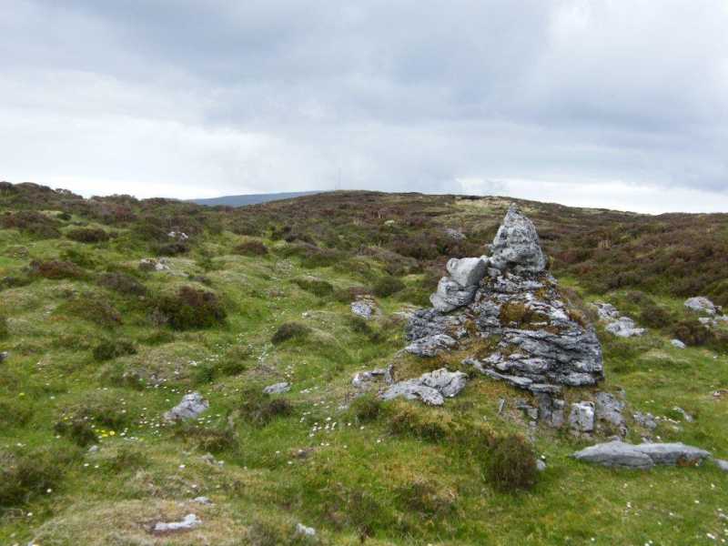
Picture: Cairn on Keelogyboy
A cairn of sorts.
by paddyhillsbagger
3 Jun 2013
Keelogyboys top is uninspiring bog and peat hags as other walkers have commented. I did come across this curious cairn in the SW corner of the mountain on-route to the SW Top. It's around F (G770 388) on top of the cliffs pictured in the short summary. Truskmores masts are just visible in the background. Linkback: mountainviews.ie/summit/665/comment/15006/
Just visited the south face at about 2.30pm on 22/12/10 , approached from northern slopes , long hard walk in deep snow. Hard to judge extent of bog on top so didnt hang around.
ill never leave without gaiters again ! excellent views to south , and also of truskmore to north . worth the effort. Linkback: mountainviews.ie/summit/665/comment/6179/
Use of MountainViews is governed by conditions and a privacy policy.
Read general information about the site. Opinions in material here are not necessarily endorsed by MountainViews.
Hillwalking is a risk sport. Information in comments, walks, shared GPS tracks or about starting places may
not be accurate for example as regards safety or access permission. You are responsible for your safety and your permission to walk.
See the credits and list definitions.


 Our Facebook page.