This website uses cookies, which are small text files that the website puts on your device to facilitate operation. Cookies help us provide a better service to you. They are used to track general user traffic information and to help the website function properly.
Feature count in area: 44, by county: Tipperary: 36, Limerick: 8,
OSI/LPS Maps: 52, 53, 54, 58, 59, 60, 65, 66
Highest Place: Keeper Hill 691.6m
Starting Places (31) in area Midlands SW: Ballincurra Hill South, Ballyhourigan Wood Loop Walk, Barnane Lodge, Castlewaller Wood Forest Road, Coillte Knockanroe, Commanealine Wood, Commaun Beg North, Cullaun South, Cummer South, Curreeny Wood, Doonane Forest Carpark, Foildhine Mulkeir Rivers, Glenaneagh Park, Glenstal Wood CP, Gortagarry Hill West, Greenan Cross, Knockadigeen Hill SW, Knockanora East, Knockanully, Knockaviltoge East, Knockfune Wood Bend, Knockmaroe Wood, Knockmehill South, Knockteige SW, Nicker, Raven's Rock, Ring Hill West, River Doonane, The Lookout, Tobernagreana, Upperchurch
Summits & other features in area Midlands SW: Cen: Mauherslieve: Cummer 405m, Foilduff 400m, Knockmaroe 411m, Mauherslieve 543m E: Upperchurch Hills: Knockalough 427m, Knockaviltoge 364m N: Knockshigowna: Knockshigowna 212m NE: Devilsbit: Benduff 455m, Black Hill 228m, Devilsbit Mountain 480m, Gortagarry 458m, Kilduff Mountain 445m, Knockanora 433m NE: Templederry: Ballincurra Hill 403m, Commaun Beg 403m, Cooneen Hill 467m, Coumsallahaun 320m, Knockadigeen Hill 402m NW: Arra Mountains: Corbally Hill 339m, Tountinna 457m NW: Silvermine Mountains: Silvermine Mountains East Top 479m, Silvermine Mountains Far East Top 410m, Silvermine Mountains West Top 489m SE: Hollyford Hills: Falleennafinoga 388m, Foildarg 440m, Glenaneagh 420m, Gortnageragh 418m, Knockastanna 444m, Knockbane 433m, Lackenacreena 413m, Ring Hill 426m, Tooreen 457m SW: Slieve Felim: Cullaun 460m, Derk Hill 236m, Knockroe 204m, Knockseefin 235m, Slieve Felim 427m, Slieve Felim East Top 423m, Slieve Felim South Top 407m W: Keeper Hill: Bleanbeg 368m, Boolatin Top 446.6m, Keeper Hill 691.6m, Knockane 411m, Knockfune 452m
Note: this list of places may include island features such as summits, but not
islands as such.
Cullaun, 460mHill Collán A name in Irish,
Place Rating ..
(Ir. Collán [OSI], poss. 'height'), Limerick County in Munster province, in Carn Lists, Cullaun is the 699th highest place in Ireland.
Grid Reference R82420 57410,
OS 1:50k mapsheet 66 Place visited by: 46members, recently by: chelman7, jollyrog, Moirabourke, Arcticaurora, Krzysztof_K, CusackCharlie, Jai-mckinney, Oscar-mckinney, Carolyn105, johncusack, TippHiker, garrettd, JohnRea, LiamG1951, maryblewitt
I visited this place: NO (You need to be a logged-in member for this.)
Longitude: -8.260552, Latitude: 52.66793, Easting: 182420, Northing: 157410,
Prominence: 255m, Isolation: 1.5km ITM: 582376 657449 Bedrock type: Greywacke, siltstone & grit, (Hollyford Formation) Notes on name: Given its altitude , Collán is more likely to be the element meaning 'height' which appears in names such as Sliabh gCallann (Slieve Gallion in Derry) and Collann (Collon, Co. Louth) than coll(-án), 'hazel' . See also Slievecallan, Co. Clare.
Short or GPS IDs, 6 char: Culaun, 10 char: Cullaun Linkback: https://mountainviews.ie/summit/585/
Gallery for Cullaun (Collán) and surrounds
Summary
for Cullaun (Collán):
The easy and the awful
Summary created by Colin Murphy, jackill
2022-02-11 14:39:01
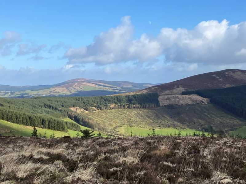
Picture: As seen from Slieve Felim South top, Cullaun on right.
Park at A (R82389 59162), a forest entrance with room for 5 cars.Follow the forest track taking the first left onto the Slieve Felim way, follow the way, ignoring the many offshoots, to B (R81091 58087). Turn left here and then right at C (R81207 58049) up a narrow track. When this ends cross rough ground to point 423 mtrs.From point 423 mtrs head downhill east, following a fence and a muddy track to D (R81263 57802). Follow the muddy track between two forests, do not panic it is passable despite first appearances, keep to the right hand side. As you exit the far end cross a wire fence. Rough ground and high heather separate you from the summit. The summit is marked by a hole, a broken tv mast and some stones with names.
An approach from the east is possibly the easiest. There is an entrance at E (R83875 57275) that looks like someone's gate, (pillars & curving walls) but is actually a forest track. This is just about drivable with care, taking you to Cullaun (R824 567), where there is room for 2 cars. A steepish, stoney track leads up the edge of the forest to open hillside. Another narrow track of sorts extends to the NW through the heather, almost all the way to the high point.
I headed off for the Slievefelims on Wed 09/09. I left the limerick/thurles road at Rear Cross and headed off for Cappamore. I had intended to drive up the road at E (R83875 57275) but I missed the entrance. I continued on this road until I got to lackamore Quarry on my right. Across from this there is an entrance into the woods with parking for about six cars. I followd this track up to a pair of gates at F (R83400 56000). I turned left after the gates and headed for the end of the road. Here I turned right and up onto the road I had intended first. I met a man here and he told me I could have driven to that point. He explained that the road starts with a set of pillars. I had seen these but rejected them as I thought they led into someones farm. When I got to the edge of the forest at G (R82323 56888) I turned right and followed the forest service road to nearly the summit. When you get to the high point t turn right and follow the track to the summit. The summit has a small hole dug out for shelter and a white flag on a piece of 2 by 1. On my return to Rear Cross I marked the entrance I intended first and measured the distance to Rear Cross. So if you are going to go on this walk 2.5 KM after rear Cross turn right for this road as you head out for your walk. this road is driveable all the way around. It has a set of pillars and a wall similar to a private residence, but in need of some repair. Linkback: mountainviews.ie/summit/585/comment/4284/
Read Less
Read More
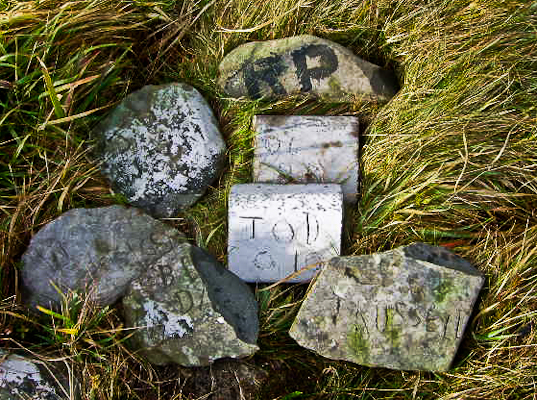
Picture: written in stone(ok, maybe one in concrete)
Stoned in Tipperary
by jackill
20 Dec 2010
Being mooned on the Knockmealdowns was an unusual experiance on a mountain
Topless sunbathers in the Galtys was another.
Makes this seem somewhat tame but still unusual.
Stones with names? answers on a postcard please. Linkback: mountainviews.ie/summit/585/comment/6173/
Read Less
Read More
Plan B
by aidand
9 Dec 2011
There is an easier route up Cullaun. From Rear Cross take the Cappamore Road. After about a mile there is an entrance on the right with two stone pillars. This looks like the entrance to a farm, but is actually a forest road. Drive in this entrance and up the hill. It 's a bit rough but fine in an ordinary car. Park when you reach the forest, there is room for half a dozen cars. Follow the outskirts of the forest on the right and you will reach the summit within about 15 minutes. Linkback: mountainviews.ie/summit/585/comment/6644/
Read Less
Read More
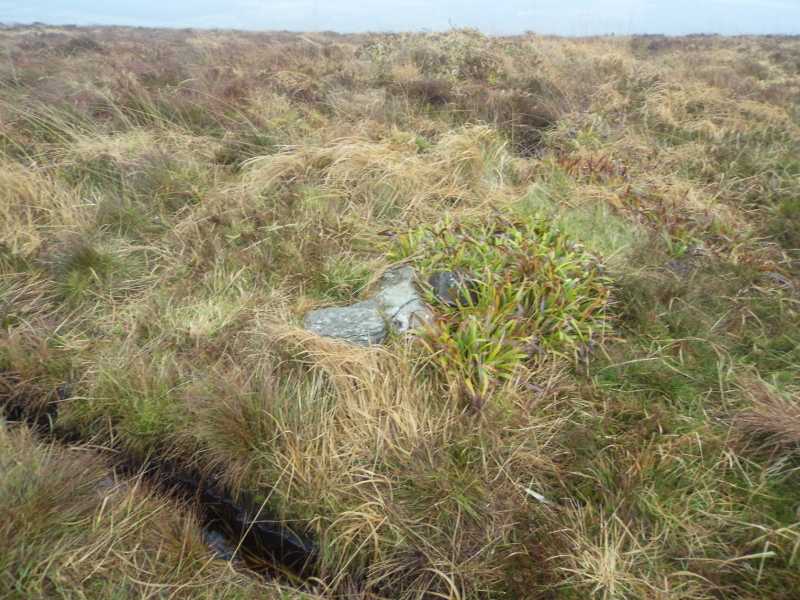
Picture: A cairn?
A quick bag.
by TommyV
24 Nov 2018
Aidand's directions are spot on. The road that looks like an entrance to a house actually leads into a forest, it is rough but manageable if you drive very slow. I drove as far as an old abandoned house at H (R82263 56755). Followed Aidand's directions to a very unremarkable summit that is marked by few stones that are barely noticeable as the heather has almost grown over them. A quick bag and can be combined with some of the other unremarkable lesser known hills in the area. Linkback: mountainviews.ie/summit/585/comment/20208/
Read Less
Read More
virago on Cullaun
by virago
10 Mar 2010
Driving to Limerick every day and looking up at Cullaun just out side of Rearcross, today I said why not. The weather was mighty, a good blast of frost last night ensured the ground was sound, maybe a little to hard. I approached Cullaun from the Rearcross to Newport road near the Clare river. I followed the Slieve Feliim Way as far as Sliabh Eibhlinne. I then left the forest track and headed for the summit of Cullaun. The climb was easy enough but had to take my time due to a recent injury. the views of Limerick and Tipperary were mighty on the day. The walk was took us about four hours. well worth it. Linkback: mountainviews.ie/summit/585/comment/4496/
Use of MountainViews is governed by conditions and a privacy policy.
Read general information about the site. Opinions in material here are not necessarily endorsed by MountainViews.
Hillwalking is a risk sport. Information in comments, walks, shared GPS tracks or about starting places may
not be accurate for example as regards safety or access permission. You are responsible for your safety and your permission to walk.
See the credits and list definitions.


 Our Facebook page.