This website uses cookies, which are small text files that the website puts on your device to facilitate operation. Cookies help us provide a better service to you. They are used to track general user traffic information and to help the website function properly.
Feature count in area: 27, all in Galway,
OSI/LPS Maps: 37, 38, 44, 45, EW-CON
Highest Place: Binn idir an dá Log 702m
Starting Places (42) in area Maamturks: An Móinín Mór, Bealanabrack River Tributary, Bundorragha Estuary Cross, Cannaclossaun, Carraig Bar, Connemara Mountain Hostel, Delphi Resort, Dernasliggaun, Drehidanookera Bridge, Failmore River, Fee Lough SW, Glashmore Bridge, Glencraff Road End, Gleninagh River, Gowlaunlee Lake, Illaunroe South, Killary Boat Tour Pier W, Knocknafaughy SW, Kylemore River, Leenane, Leenane Hotel, unuseableLeenane R336, Lehanagh Lough N, Lehanagh Lough SE, Lough Fee East, Lough Nacarrigeen S, Lough Shindilla S, Maum Bridge Road Lower, Maum Bridge Road Mid, Maum Bridge Road Upper, Maumwee Lough, Nambrackkeagh Lough, Oorid Lough, Owenwee River, Pas Mám Éan CP, Rinavore East, Rinavore SW, Shanvally, Tawnabeg Lough North, Tooreennacoona River, Western Way Cnoc na hUilleann, Western Way Inagh Cottages
Summits & other features in area Maamturks: N: Leenaun: Maumturkmore 488m, Búcán 550m, Leenaun Hill 618m, Leenaun Hill Far North-West Top 556m, Lettershanbally 324m, Meall Cheo 578m, Taobh Dubh 422m N: Maumturks N Cen: Barrlugrevagh 558m, Letterbreckaun 667m, Letterbreckaun NE Top 603m, Knocknahillion 607m, Knocknahillion North Top 541m, Cúlóg 435m S: Maumturks S Cen: Binn Chaonaigh 633.5m, Binn idir an dá Log 702m, Binn idir an dá Log SE Top 659.3m, Binn Mhairg 612.4m, Knocknagur 310m S: Maumturks South: Binn Mhór 660.6m, Binn Mhór NE Top 641.2m, Binn Mhor West Top 595.8m, Binn Mhor East Top 631.3m, Lissoughter 401m, Corcogemore 610.1m, Mullach Glas NE Top 432m, Lackavrea 396m, Mullach Glas 621.3m
Note: this list of places may include island features such as summits, but not
islands as such.
Corcogemore, 610.1mMountain Corcóg A name in Irish,
Place Rating ..
(Ir. Corcóg [TR], 'cone' or 'beehive'), Galway County in Connacht province, in Arderin, Vandeleur-Lynam Lists, Corcóg is the 266th highest place in Ireland. Corcóg is the most southerly summit and also the second most easterly in the Maamturks area.
Grid Reference L95263 49137,
OS 1:50k mapsheet 45 Place visited by: 305members, recently by: Hillwalker65, taramatthews, orlaithfitz, maoris, PiotrR, SeanPurcell, Prem, Carolineswalsh, Kaszmirek78, Krzysztof_K, bagoff, farmerjoe, Shox, Miisterchief, keith.dillon
I visited this place: NO (You need to be a logged-in member for this.)
Longitude: -9.578407, Latitude: 53.482031, Easting: 95264, Northing: 249138,
Prominence: 225.8m, Isolation: 1.1km ITM: 495236 749160 Bedrock type: Pale quartzites, grits, graphitic top, (Bennabeola Quartzite Formation) Notes on name: As Tim Robinson points out, the Ordnance Survey has been incorrectly calling this mountain 'Leckavrea' for a hundred and fifty years. Leckavrea (Ir. Leic Aimhréidh) is the mountain to the E on the other side of Mám Aodha.
Short or GPS IDs, 6 char: Crcgmr, 10 char: Crcgmr Linkback: https://mountainviews.ie/summit/256/
Gallery for Corcogemore (Corcóg) and surrounds
Summary
for Corcogemore (Corcóg):
Whitish quartizite mountain on a steep sided ridge with fine views.
Summary created by simon3
2022-05-27 06:33:29
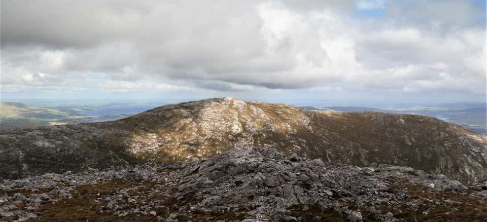
Picture: Corcóg from the west, showing the NS ridge that it is on.
Corcóg is the eastern end of the higher Maamturks, the spectacular linear range from near Maam Cross to Leenane. Its top is on an approximately NS ridge of over 1km. Famous for the Maamturks Challenge which starts on this mountain, it can be incorporated into shorter walks often from the south.
From the east start on the road at around Mám Bg Mid (L96487 49897). You can proceed straight to the summit but a slightly less steep option goes sw first and then gains height more slowly.
From the south start at around Drhid'ook (L93688 46767) from some parking on a rough road leading off the N59. Be very careful of closing gates meticulously around here. Follow a main forest road eastwards until it branches north beside a stream.
The views on a good day include a lot of the Maamturks and also Joyce Country, Lough Corrib and the Connemara coastline.
In mist and with map and compass the route to connect to Mullach Glas and the rest of the Turks is a classic problem in accurate navigation as it is necessary to proceed NW along the ridge from the summit to turn off at the correct place to get to the col.
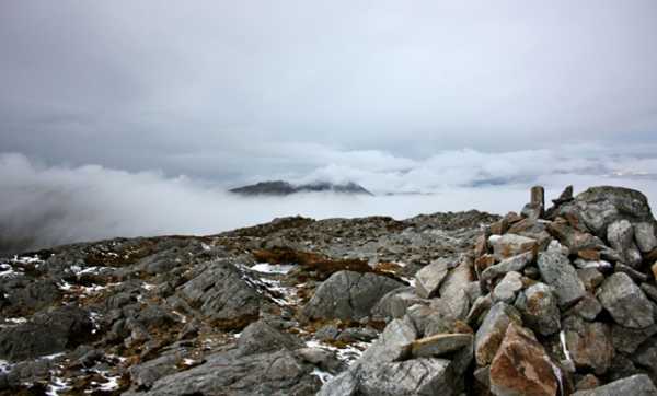
I parked at A (L97358 47989), taking care not to block access to the gate off the R336 Maam Cross - Maam road. There's space for one or two cars here. I headed northwest, pretty much in a straight line towards the summit. Boggy at first, the terrain becomes increasingly steep until you get to within a kilometre or so of the summit, whereupon you have to scale the walls of what just might be a corrie. Up top, the terrain changes from bog to the typical Maamturks/Twelve Bens summit carpet of rock. The clouds lifted momentarily, enabling me to take this shot across to Mullach Glas and Binn Mor.
If you're planning on heading for these peaks, I'd recommend aiming first for B (L948 497), before heading west. Linkback: mountainviews.ie/summit/256/comment/4435/
Read Less
Read More
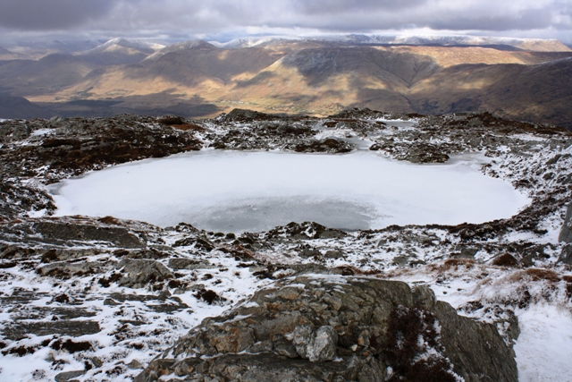
Picture: White, brown, black, grey
A view from Corcogmore
by wicklore
19 Aug 2013
This photograph might take a moment to make sense as it is a bit of a kaleidescope of colours. It is of a frozen pool high on Corcogmore, with the Bunnacunneen and Lugnabrick summits beyond, and snow covered Devilsmother and Maumtrasna taking up the rear.This is one of the potential views availale to you if you venture up here in the winter. A clear day in summer would be even better! Linkback: mountainviews.ie/summit/256/comment/15082/
Read Less
Read More
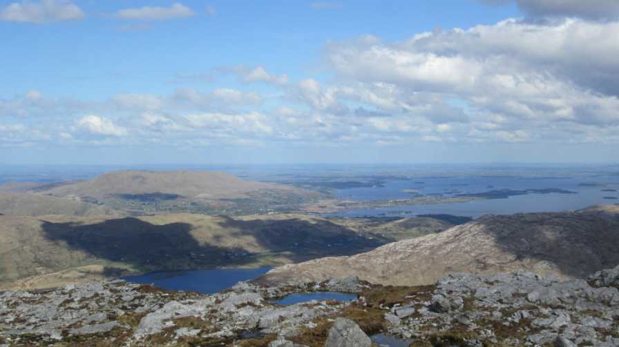
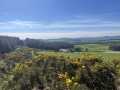
Picture: Looking ENE from the summit area towards Lough Corrib and Benlevy.
First or last of a rewarding route.
by David-Guenot
11 Jun 2016
I climbed Corcog as the last summit of a fantastic loop, which also included Binn Mhor and Mullach Glas (see track 3238). From the col with Mullach Glas, I kept to the left of the fence and followed it as it veers right, before making a diagonal ascent almost straight to the top, avoiding the steep ground to the W. This made for a rather gradual ascent over the rough ground, with fine views over the steep E slopes of Mullach Glas and the S of Connemara. Great views from the top, over the immense Lough Corrib to the E, Joyce Country to the N and the rest of the Maumturks to the WNW, with even Mweelrea, Ben Gorm, the Sheeffrys, Devilsmother and Maumtrasna visible in the distance. Linkback: mountainviews.ie/summit/256/comment/18576/
Read Less
Read More
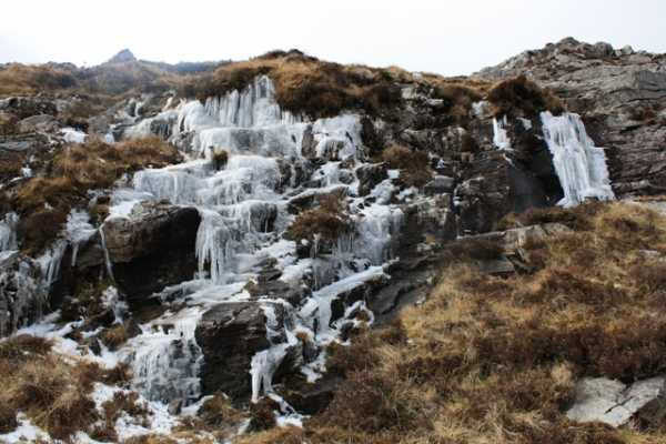
Picture: Water(doesn't)fall
wicklore on Corcogemore
by wicklore
28 Feb 2010
Corcogemore appears to have provided many interesting and ‘just happened to be there’ photo opportunities – csd’s photo of the cloud inversion, bryanmccabe’s snap of a curiously coloured Corcogemore from Lackavrea, and Colin Murphy’s shot of a rain-induced torrent of water. My contribution to this stock of curious photos is the attached picture which shows one of these torrents frozen in mid flow. It may even be the same waterfall as shown in Colin Murphy’s picture. Cute as it looked it still provided a hazardous obstacle to be negotiated. I discovered the best approach was to back off and find a way around! Linkback: mountainviews.ie/summit/256/comment/4452/
Read Less
Read More
No luck in reaching the top :(
by 196xim
21 Mar 2022
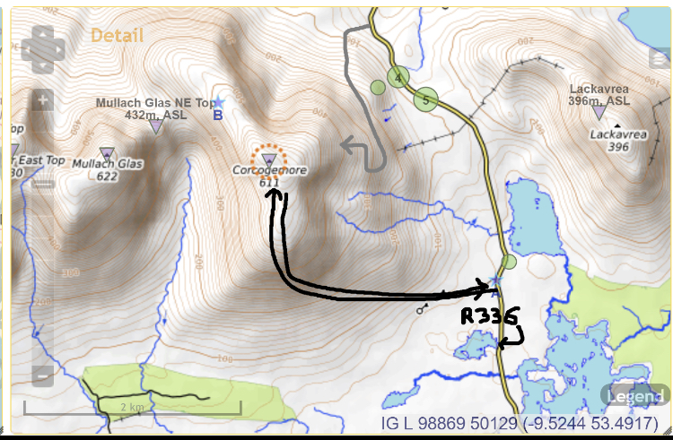
Gave this a blast today. Tough tough going. Ended up doing the rough route as attached in grey (I think) The black is what I thought could be an option but does not look like an option in the flesh.
Did an hour and a half up and decided to call it a day and come down. According to Google we were at about 350 metres but if felt like a lot more. I honestly thought we were not too far from the top (611 metres) but was hard to know.
No clear path up, a lot of false tops and hard to know how much more it would have taken us. The going was very tough in parts, scrambling on all fours in bits. Very steep for me anyways, I am not a seasoned climber or anything. I would love to have made the top but decided against it as was not sure of the route, when you look up it’s daunting with no clear route. We tried to get to a shoulder and go up that but didn’t work out , then moved in from the shoulder as looked like some possibilities, but no luck and decided to throw the towel in after a good effort. Twas a good hour and a half climb but no cigar. We may give it a try another day if we could try and figure out the safest route Linkback: mountainviews.ie/summit/256/comment/23436/
Use of MountainViews is governed by conditions and a privacy policy.
Read general information about the site. Opinions in material here are not necessarily endorsed by MountainViews.
Hillwalking is a risk sport. Information in comments, walks, shared GPS tracks or about starting places may
not be accurate for example as regards safety or access permission. You are responsible for your safety and your permission to walk.
See the credits and list definitions.


 Our Facebook page.