Guestuser: Login or enrol?
- Home
- Main Display
- Main Display (Old)
- Find a Walk
- Display INTRODUCTION
- DONATE
- Click below for your
profile & contributions
guestuser- New
- Tracks, Walks
- Challenge
- Community
- Lists & Logs
- Popular Lists:
- County Highpoints
- Range & Area Highpoints
- Local 100
- Highest Hundred
- Vandeleur-Lynams
- Arderins
- Carns
- Best rated
- Irish 900 up
- Irish Island
- Munros
- All Lists
- Shorter Irish
- County Highpoints
- Range & Area Highpoints
- Highest Hundred
- Local 100
- Local 100 (pre2014)
- Local Historical Cultural
- Best rated
- Irish 900 up
- Larger Irish
- Arderins
- Arderin Begs
- Arderins + Arderin Begs
- Vandeleur-Lynams
- Vandeleur-Lynams + Arderins
- Carns
- Binnions
- Highest 50 per Province
- Island Features
- Irish Island
- Coastal Hills
- Irish 600 up
- Irish 500 up
- British
- Munros
- British 600 up
- British 500-600
- British Marilyns
- Comprehensive
- All Irish summits
- All Irish features
- All British summits
- All Britain+ Ireland
- Special
- Analysis List
- Simple Irish Listings
- Simple Irish & British Listings
-
- More
- Motley Views
Welcome to MountainViews
If you want to use the website often please enrol (quick and free) at top right.OverviewFor more map options click on any overview map area or any detail map feature.Detail Map FeaturesFind Suggested Walks
Find hill, mountain, island, coastal feature.Videos


Recent Contributions
 Get Notifications
Carrigroe: Twin tops
Knocknakilton & Cummeen, Dingle Penninsula
Kilbrony Park Ramble
Grieve Hill: Summit position recently revised.
Leean Mountain: Ireland's Best Small Hill?
Croaghnageer and Croghanirwore
Scarr North-West Top: Popular spot in the heart of the mountains
Blackstairs Mountain: Good access and a great viewpoint above a patchwork quilt
9 km walk around Mullaghmeen Woods April 2025
Silvermines Hydro Project
Brown Mountain: Granite - mica schist boundary
Callahaniska: Simple but very rewarding
Conditions and Info
Use of MountainViews is governed by conditions and a privacy policy.
Read general information about the site.
Opinions in material here are not necessarily endorsed by MountainViews.
Hillwalking is a risk sport. Information in comments, walks, shared GPS tracks or about starting places may not be accurate for example as regards safety or access permission. You are responsible for your safety and your permission to walk.
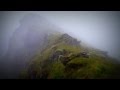
See the credits and list definitions.Video displayBrandon Group Area S: Ballysitteragh SubareaPlace count in area: 15, OSI/LPS Maps: 70, EW-DC, EW-DW
Highest place: Brandon, 951.7m
Maximum height for area: 951.7 metres, Maximum prominence for area: 934 metres,
Places in area Brandon Group:
Cen: Faha Ridge:Benagh 822.5mFaha Ridge 809.2m
N: Brandon Point:Faill an tSáis 430.7m
N: Brandon Ridge North:Brandon Far North Top 840.1mBrandon North Top 895.4mMasatiompan 761.9mPierasmore North Top 700mPierasmore 745.7m
S: Ballysitteragh:An Bhinn Dubh 479.2mBallysitteragh 623mBeennabrack 608.5m
S: Brandon Ridge South:Gearhane 803mBrandon Peak 840mBrandon 951.7mBrandon South Top 790m
Note: this list of places includes island features such as summits, but not islands as such.
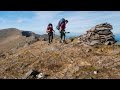
(Ir. An Scraig [TCCD], 'rocky outcrop') Kerry County in Munster Province, in Arderin, Vandeleur-Lynam Lists, Cross-bedded sandstone Bedrock
Height: 623m OS 1:50k Mapsheet: 70 Grid Reference: Q46055 05717
Place visited by 256 members. Recently by: SeanPurcell, StJohn, Ansarlodge, srr45, orlaithfitz, Alatar78, JustMe, patman1974, RosieMc, Aidan_Ennis, discovering_dann, glencree, dino, farmerjoe1, jackosI have visited this place: NO (You need to be a logged-in member to change this.)Longitude: -10.251479, Latitude: 52.182203 , Easting: 46055, Northing: 105717 Prominence: 218m, Isolation: 0.9km
ITM: 446038 605767 , GPS IDs, 6 char: Blystr, 10 char: Blystrgh
Bedrock type: Cross-bedded sandstone, (Coumeenoole Sandstone Formation)
Also known as Cnoc Bhaile Uí Shé [OSI], 'hill of Baile Uí Shé', from Ballyhea(-bought) townland. The English form Ballysitteragh could be from Baile Suiteoireach, 'the townland of the camp/barracks', but the circumstances of its naming are unclear. Coumhenry, Coumgraig and Coumthrive are hollows below the mountain on the N. side. Previously Ballysitteragh in MV. An Scraig is the 252nd highest place in Ireland.
Linkback: https://mountainviews.ie/summit/238/COMMENTS for Ballysitteragh (An Scraig) 1 of 1  Follow this place's comments
 Height layer: © MapTiler

MountainViews.ie, a Hill-walking Website for the island of Ireland. 2500 Summiteers, 1480 Contributors, maintainer of lists such as: Arderins, Vandeleur-Lynams, Highest Hundred, County Highpoints etc

 Colin Murphy
 Collaborative entry
 Geo
Geo
 Peter Walker
 hibby
hibby
 Collaborative entry
 ceadeile
 hibby
hibby
 Collaborative entry
 Visit our Facebook page.