Cookies.
This website uses cookies, which are small text files that the website puts on your device to facilitate operation. Cookies help us provide a better service to you. They are used to track general user traffic information and to help the website function properly.
Features
Nearby features appear when you click the map.
Declutter tracks on map.
Place Search
Video
X
Pub: by
Cooley Mountains Area , S: Cooley South Subarea
Feature count in area: 12, all in Louth, OSI/LPS Maps: 29, 36, EW-CLY
Highest Place: Slieve Foye 587m

Starting Places (24) in area Cooley Mountains:
Annaloughan Loop Walk CP, Beck's Lane, Cadger's Bridge, Carlingford Car Park, Carlingford Greenway, Clermont Junction, Clermont Pass Bridge, Corna Mucklagh House, Deserted Village, Feede South, Flagstaff Viewing Point, Foxes Rock SW, Glenmore Tain Way, Grange Cross, Long Woman's Grave, Lower Faughil Road, Slieve Foye Viewing Point, Slievefoy Forest CP, Slievenagloch N, Spellickanee Mid, St Oliver's Park, The Ben Rock, The Lumpers, Two Mile River CP

Summits & other features in area Cooley Mountains:
N: Cooley North: Anglesey Mountain 421m, Carnavaddy 475m, Clermont 444m, Clermont Carn 510m, Clermont Carn NE Top 448m
S: Cooley South: Barnavave 350m, Slieve Foye 587m, Slieve Foye North-West Top 548.1m, Slievenaglogh 310m, The Eagles Rock 530m, The Foxes Rock 404m, The Ravens Rock 457m

Note: this list of places may include island features such as summits, but not islands as such.
Rating graphic.
Barnavave, 350m Hill Bearna Mhéabha A name in Irish,
Place Rating ..
Logainm: the gap of Méabh, Louth County in Leinster province, in Local/Historical/Cultural Lists, Barnavave is the 1058th highest place in Ireland. Barnavave is the most easterly summit and also the second most southerly in the Cooley Mountains area.
Grid Reference J17700 10000, OS 1:50k mapsheet 29&36
Place visited by: 85 members, recently by: TipsyDempy, glencree, Carolineswalsh, pdtempan, DeirdreM, pinchy, arthurdoylephoto, Oscar-mckinney, marcellawalking, archmeister, MichaelButler, annem, AntrimRambler, eflanaga, gernee
I visited this place: NO (You need to be a logged-in member for this.)
Longitude: -6.204773, Latitude: 54.025857, Easting: 317700, Northing: 310000, Prominence: 45m,  Isolation: 2.1km
ITM: 717623 810009


  Short or GPS IDs, 6 char: Brnvv, 10 char: Barnavave

Linkback: https://mountainviews.ie/summit/1504/
Gallery for Barnavave (Bearna Mhéabha) and surrounds
Summary for Barnavave (Bearna Mhéabha): Double humped, easy to visit, good views.
Summary created by simon3 2018-01-22 22:17:40
            MountainViews.ie picture about Barnavave (<em>Bearna Mhéabha</em>)
Picture: Barnavave from the north with view south.
One way to go up is from Carlingford. Start at around OlivrPk (J1839 1095) up a path (not the adjacent track). Following the path makes for an easy ascent. It is also possible to start on the SW side for example at GlMor Tn (J16000 10505). The top area has a curious double summit. The higher westerly summit has a cross on it, the lower northerly one overlooks Carlingford and has a low trig pillar. There is a ridge extending south from the top to another slightly lower peak as yet of unknown name.

A great reason to go to Barnavave is the view south which may include the distinctive triangular shapes of the Great and Little Sugarloaf in Wicklow (98km away)
Linkback: mountainviews.ie/summit/1504/comment/18839/
Member Comments for Barnavave (Bearna Mhéabha)
Comment create / edit display placeholder

            MountainViews.ie picture about Barnavave (<em>Bearna Mhéabha</em>)
Picture: Just stand in that gap for a minute!
Kerlingfjord
by Bunsen7 30 Jan 2018
A number of years ago the BBC ran an Irish language show called "Ar Scath na Sleibhte", which provided a bit of inspiration for me to take a visit up to Carlingford, or "Carlainn" as I was to learn the Gaelic name to be. There are some clips and photos from the series still carried on the bbc website here (clips may not play in ROI):

http://www.bbc.co.uk/programmes/p03fw143/p03fw10k

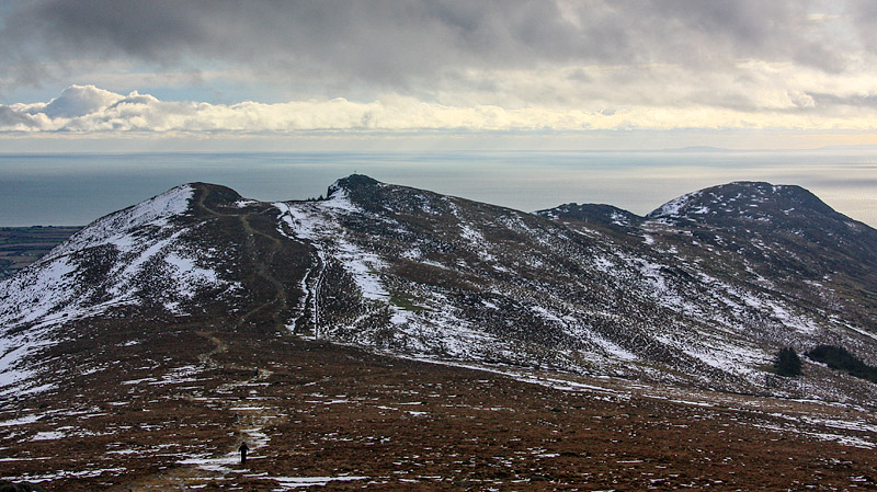
The series was mainly focused on the mountains of Ulster but included an episode on "na Sleibhte Chuailnge", the Cooley Mountains. This episode obviously resonated with me as I learned some of the mythology of Maeve's Gap, “Bearna Mheabha” being anglicised as Barnavave, the gap which is visible when descending south-east off Slieve Foye.

While I like the tales of a giant or even of Maeve’s army digging out the rocks – the “Tain Bo Cuailnge” epic sounds like a long read. A geologist will probably give a more scientific explanation of the gap arising from a fault line in the rock with granite between two humps of gabbro. More on the geology of the area can be found here: A geological field guide to Cooley, Gullion, Mourne and Slieve Croob by Sadhb Baxter.
http://louthheritage.ie/publications.shtml

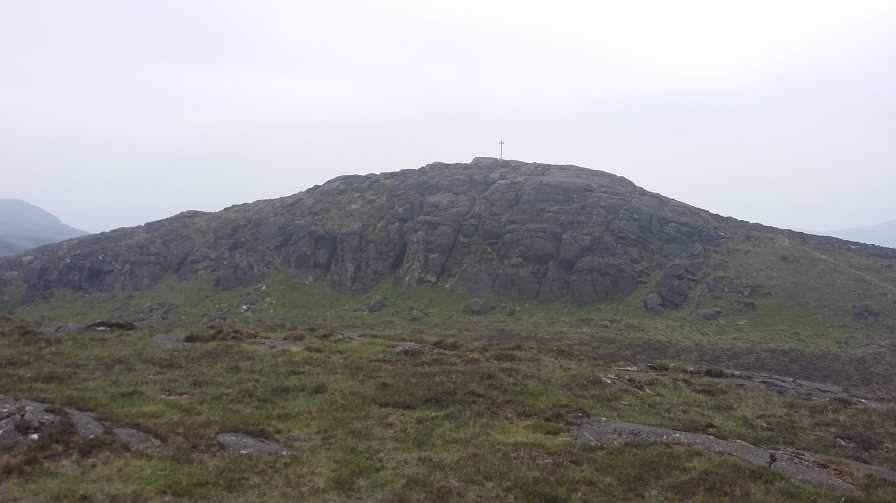
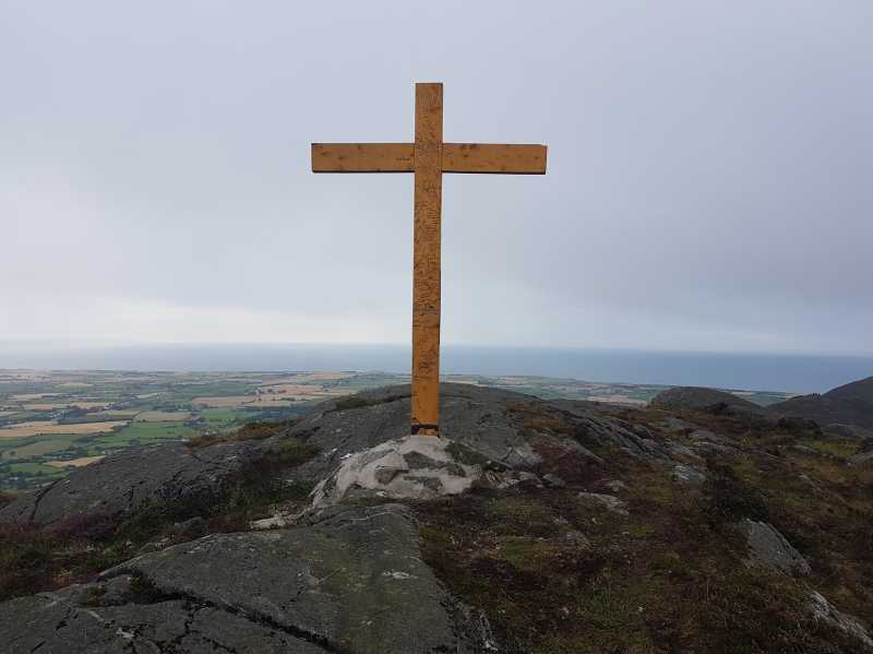
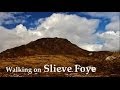
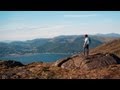
Though my primary objective was Slieve Foye and Barnavave just provided a slight detour on the descent, I recall thinking (like others have commented) that of itself Barnavave would make a very fine family walk from Carlingford (but more than enough to break a sweat from sea level) given that it can be accessed on a pretty low gradient track. There are fine views across the Lough from the trig pillar top, even when cloud has obscured Slieve Foye. I met three generations of the same family that had ascended a less taxing route from the west, the youngest daubing initials on the cross, which strangely seems to be the done thing.

Back then to the view of the “Lough”. If the Irish called this stretch of water “Cuan Carlainn”, it was the Norsemen that added the “ford”. The reason is as obvious looking north-east from Barnavave as anywhere. You've a bird's eye view of a very fine fjord, at least in name if not textbook glaciated character! I suppose the vikings should know what's a fjord and what's not! Linkback: mountainviews.ie/summit/1504/comment/19844/
Read Less
Read More

Tain Bo Cualinge
by Bunsen7 30 Jan 2018
'Archaeology Ireland' Heritage Guide number 69: "The Route of An Táin Bó Cúailgne in County Louth", which can be found at the link below, comments on the mythology of Barnavave as follows:

"Barnavave: Having failed to cross the Cronn, Medb’s forces tracked up Glenmore to the river source. The story relates that ‘they would have gone between its source and the mountain only that Medb would not allow it [preferring] that they should go across the mountain so that the track they made might remain there for ever as an insult to the men of Ulster. So they … dug up the earth in front of them (to make a pass through the mountain) which was called Bernas Bó Cúailnge.’ The gap is still there, right on the summit of Barnavave Mountain."

It also seeks to clarify another point of contention regarding Barnavave that you may encounter:
"Most academic writers have equated Bernas Bó Cúailnge with the Windy Gap at the head of Glenmore, but this ignores what the OS maps, farmers and hill-walkers have known for generations: that Barnavave
(Medb’s Gap) is the Bernas Bó Cúailnge (Gap of the Cows of Cooley) of the Táin. The
dramatic but entirely natural fault-line on its summit is visible only from a couple of points on the lowlands, most notably from the village of Grange."

http://louthheritage.ie/publications.shtml Linkback: mountainviews.ie/summit/1504/comment/19845/
Read Less
Read More

            MountainViews.ie picture about Barnavave (<em>Bearna Mhéabha</em>)
Picture: Summit Cross.
Gentle Ascent.
by sandman 9 Aug 2017
At times the route up hill from Carlingford may be too steep for some and for those who wish to visit the new cross on Barnavave the option is to ascend from the opposite side . From GlMor Tn (J16000 10505) you can gently follow the Tain Way up to the ridge which connects this hill and Slieve Foye, a few meters before the ridge bear right and if you visit the trig first you will be rewarded with fine views over Carlingford , a short walk thru the little wooden gate will take you up to the cross. Linkback: mountainviews.ie/summit/1504/comment/19628/
Read Less
Read More
EDIT Point of Interest
text
Videos


Recent Contributions
x
Conditions and Info
Use of MountainViews is governed by conditions and a privacy policy.
Read general information about the site.
Opinions in material here are not necessarily endorsed by MountainViews.
Hillwalking is a risk sport. Information in comments, walks, shared GPS tracks or about starting places may not be accurate for example as regards safety or access permission. You are responsible for your safety and your permission to walk.
See the credits and list definitions.

OSi logo
OSNI/LPS logo
Open Street Map
(Various variations used.)
British summit data courtesy:
Database of British & Irish Hills