This website uses cookies, which are small text files that the website puts on your device to facilitate operation. Cookies help us provide a better service to you. They are used to track general user traffic information and to help the website function properly.
Feature count in area: 4, all in Galway,
OSI/LPS Maps: 37
Highest Place: Tully Mountain 356m
Starting Places (15) in area West Connemara: Bridge St Clifden, Bundouglas Bay, Cleggan House, Coorhoor Lough North, Gortdrummagh West, Letterfrack Lodge, Lough Natawny, Lough Tanny, Omey Strand, Owen na Baunoge River, Ross Beach, Ross Point, Skeaghatimull, Sky Road, Tievegarriff
Summits & other features in area West Connemara: N: Cleggan: Knockaunbaun 146m, Maumfin 172m N: Tully: Tully Mountain 356m S: Clifden: Gortrumnagh 174m
Note: this list of places may include island features such as summits, but not
islands as such.
Maumfin, 172mHill Mám Fionn A name in Irish,
Place Rating ..
(Ir. Mám Fionn [TR], 'white pass'), Galway County in Connacht province, in Binnion Lists, Maumfin is the third highest hill in the West Connemara area and the 1443th highest in Ireland.
Grid Reference L64716 58860,
OS 1:50k mapsheet 37 Place visited by: 16members, recently by: nickywood, conormcbandon, wicklore, Fergalh, DeltaP, eamonoc, markwallace, deirdrenig, mdoc1969, Oileanach, chalky, taobear, juliewoods, Jamessheerin, shaunkelly
I visited this place: NO (You need to be a logged-in member for this.)
Longitude: -10.041451, Latitude: 53.562035, Easting: 64716, Northing: 258860,
Prominence: 157m, Isolation: 3.4km ITM: 464761 758841 Bedrock type: Pale quartzites, grits, graphitic top, (Bennabeola Quartzite Formation) Notes on name: Maumfin is properly the name of a townland on the slopes of this hill. Tievegarriff is another townland which extends to the summit and whose name may be connected with this hill.
Short or GPS IDs, 6 char: Mmfn, 10 char: Maumfin Linkback: https://mountainviews.ie/summit/1044/
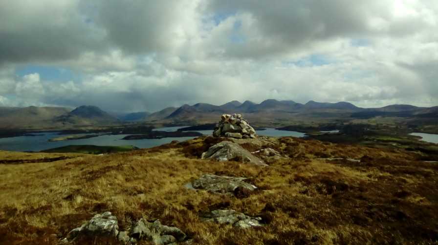
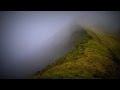
Picture: Maumfin summit cairn, with views to Ballinakill Harbour and Twelve Bens beyond
Fenced-in summit with good views
by markwallace
30 Mar 2016
Small as this hill is, it has a biggish, well-constructed summit cairn, and has nice views over Ballynakill Harbour, Twelve Bens, and the North Connemara coastline. Mweelrea, Croagh Patrick and Achill also visible on a clear day. Linkback: mountainviews.ie/summit/1044/comment/18479/
Read Less
Read More
No access on 27.02.2012
by FilHil
7 Apr 2012
Poor weather prevented me from ascending any hill in west Connemara, even Tully Mountain across the bay: fog, drizzle, low cloud at 150m, however Maumfin looked just possible on the day.
I checked out the single track road running to the north of the hill, however, all metal gates were padlocked. The east contour has many private houses and fields with cattle grazing.
An approach from the south looked a possibility, short but steep, starting from near the graveyard and church ruin. There were no cattle in the field higher up and I was on my own so a quick up & down was what I had in mind. I enquired [for permission to go up through the field] at the farm opposite the church ruin but was bluntly told by a young woman working there not to go through. I checked further west at an area called Cartron, but the gates were padlocked. Reluctantly I called it a day.
On 20/4/2017, at 07.4am drove to Tv'Garf (L65405 59318), at area noted as Tievegariff on OS sheet 37. Parked opposite old abandoned cottage, went through gate and onto a well made farm tack uphill to two old stone sheds and a cattle feeder. Much evidence here of cattle traffic, although there were none about this early. The ground was deeply rutted but reasonably dry, went behind shed to the right towards a low fence crossed this and headed uphill to the big cairn as mentioned by markwallace, there was another little rocky knoll about 80mts due west which I thought was higher than area where the Cairn stands. Linkback: mountainviews.ie/summit/1044/comment/18894/
Use of MountainViews is governed by conditions and a privacy policy.
Read general information about the site. Opinions in material here are not necessarily endorsed by MountainViews.
Hillwalking is a risk sport. Information in comments, walks, shared GPS tracks or about starting places may
not be accurate for example as regards safety or access permission. You are responsible for your safety and your permission to walk.
See the credits and list definitions.


 Our Facebook page.