- Home
- Main Display
- Main Display (Old)
- Find a Walk
- Display INTRODUCTION
- DONATE
- Click below for your
profile & contributions
guestuser- New
- Tracks, Walks
- Challenge
- Community
- Lists & Logs
- Popular Lists:
- County Highpoints
- Range & Area Highpoints
- Local 100
- Highest Hundred
- Vandeleur-Lynams
- Arderins
- Carns
- Best rated
- Irish 900 up
- Irish Island
- Munros
- All Lists
- Shorter Irish
- County Highpoints
- Range & Area Highpoints
- Highest Hundred
- Local 100
- Local 100 (pre2014)
- Local Historical Cultural
- Best rated
- Irish 900 up
- Larger Irish
- Arderins
- Arderin Begs
- Arderins + Arderin Begs
- Vandeleur-Lynams
- Vandeleur-Lynams + Arderins
- Carns
- Binnions
- Highest 50 per Province
- Island Features
- Irish Island
- Coastal Hills
- Irish 600 up
- Irish 500 up
- British
- Munros
- British 600 up
- British 500-600
- British Marilyns
- Comprehensive
- All Irish summits
- All Irish features
- All British summits
- All Britain+ Ireland
- Special
- Analysis List
- Simple Irish Listings
- Simple Irish & British Listings
-
- More
- Motley Views
Welcome to MountainViews
If you want to use the website often please enrol (quick and free) at top right.Newsletters Index
Previous Newsletters
 Annual 2025
- January 2025
- Quarterly November 2024
- Quarterly August 2024
- July 2024
- Quarterly May 2024
- Annual 2024
- January 2024
- Quarterly November 2023
- October 2023
- Quarterly August 2023
- July 2023
- Quarterly May 2023
- April 2023
- Annual 2023
- January 2023
- Quarterly November 2022
- October 2022
- Quarterly August 2022
- July 2022
- Quarterly May 2022
- April 2022
- March 2022
- Annual 2022
- January 2022
- December 2021
- Quarterly November 2021
- October 2021
- September 2021
- Quarterly August 2021
- July 2021
- June 2021
- Quarterly May 2021
- March 2021
- Annual 2021
- January 2021
- December 2020
- Quarterly November 2020
- October 2020
- September 2020
- Quarterly August 2020
- June 2020
- Quarterly May 2020
- April 2020
- March 2020
- Annual 2020
- January 2020
- December 2019
- Quarterly November 2019
- October 2019
- September 2019
- Quarterly August 2019
- July 2019
- June 2019
- Quarterly May 2019
- April 2019
- March 2019
- Annual 2019
- January 2019
- December 2018
- Quarterly November 2018
- October 2018
- September 2018
- Quarterly August 2018
- July 2018
- June 2018
- Quarterly May 2018
- April 2018
- March 2018
- Annual 2018
The Summit
Monthly newsletter of MountainViews.ie for guestuser
September 2017
NEWS - INFORMATION - RECENT CONTRIBUTIONS - FEATURES - FORUMS

NORTH, SOUTH, WEST, EAST, FRANCE, Route ideas and places to go.
Cuilcagh development - Wonderful or woeful?
Interview with Na Sléibhte Novel sort of hillwalking club.
Challenge Walks Fei Sheehy triple day reviewed and more ..
Coastal Hills for Mayo Additions and some examples here ..
3 videos featured this month. gerrym, Tony Davis, and Dezso TothUPCOMING EVENTS
MOUNTAINVIEWS: Hillwalkers' Winter Talks MountainViews Walkers Winter Talks for 2017 is now over and will resume in 2018. We are looking for further ideas, contacts and practical help.
MOUNTAIN MEITHEAL: Mountain Meitheal are keen to find more people to help.
Mountain Meitheal make practical repairs to some of the more popular areas we walk on, using a voluntary community based approach. (More information at their website.)Picture of the month 
Dulough looking towards the Ramp, Ben Lugmore and Ben Bury by marzka
For original place comment, click here.Regions: MOUNTAIN COMMENTS - TRIP REPORTS - TRACKS - SUMMARIES
In short: DiscoveryFeatured Track of the Month
Onwards and upwards in the Pyrenees
September's TOTM takes long-time contributor David-Guenot back to his homeland for a very dramatic route to the summit of Pic du Canigou, a Pyrenean mountain of enormous significance to the Catalan people. This route is perfectly possible in a day for strong walkers who don't mind a long ascent, especially armed with the included description and spectacular photographs, and would be a great objective for the hillwalker holidaying in the area. David-Guenot on Pic du CanigouMain walk Start: 08:19, End: 18:31, Duration: 10h11m, Length: 24.8km, Ascent: 1853m, Descent: 1851m
Places: Start at Lon 2.51911, Lat 42.531, end at Start (statistics such as Ascent or Length etc should be regarded as approximate. Duration depends on the speed of the person making the track)
Ascending Catalogna's sacred mountain from the hamlet of Los Masos de Vallmanya, on well-marked trails, with two breaks at the Refuge des Cortalets for coffee (on the way up) and then beer (on the way down), and about 35/40 minutes spent at the summit. There are quite a few possible routes to ascend this peak; mine follows the GR36 before joining the most popular route from the refuge (2150m), which is only accessible with a SUV. Unless you book a tour to drive you up the dirty roadtrack, you will have a minimum of ca. 1700m total ascent and thus may prefer to have a two- or three-day trip. Another popular route is from the WSW (Mariailles) and includes some scrambling up a chimney just below the summit. This bit of scrambling can also be tackled from the refuge via an unmarked trail which runs along the Crête des Barbets and meets the route from Mariailles. The 360° vista from the top is breathtaking and you can see a long stretch of the Mediterranean coast on a clear day. Just remember the big difference in height with the starting point means it can be quite cold and windy up there, which was the case on this 13. August (fortunately the wind had dropped down by the time I reached the summit).?
The coastline can already be seen during the ascent.
The views get more amazing as you get higher.
Summit in view !!

Part of the amazing vista from the top...
NORTH: Impenetrable jungle, deep gorges, swamps & quicksand?
Not quite, but that’s what it must have felt like for truescot on a day out on Crenville in the County Down Mournes – a day that turned out to be very arduous indeed.
truescot on Crenville: Maybe Nicer on a Dry Day.
I thought of adding this peak to my list of ones completed while I was in the area. The weather on the day was horrific. Down to about 20m visibility with driving rain. I just completed Slievemeen and wandered up to the right of Slieve Martin. The plan was to cut through the gap in the forest just south of Crenville. After hitting the gap and crossing over the fence I should have turned around. In ... ... Click here ...
NORTH: Bruse - now not cuts and bruise.
Notoriously if you went wrong on Bruse Hill in the North Midlands area you could find yourself in a world of nasty vegetation with hidden drops. As one experienced comementer Geo said in 2013: "Nothing can prepare you for the awfulness of this hill. Brambles, Bracken and Bushes aplenty."
Apparently as a result of a big gorse fire in 2016 the situation has changed and it is very much easier to get to the top. TommyMc on Bruse Hill, (Sliabh Brúis): Bruse Summer 2017
Since a big gorse fire in 2016, this hill is once more easily accessible to casual walkers and has been widely visited this summer. An easy approach is possible by taking the L6636 minor road off the R198 Arva-Cornafean road at 53.937356, -7.538388 and going approx. 1 mile uphill until you reach the brow of the hill, at 53.926307, -7.525937. There is very limited parking here so be prepared to ... ... Click here ...
WEST: Waterville sunset
There are many wonderful walks on the Iveragh peninsula for those prepared to keep going past the Reeks, with the wildness of the mountains in inverse proportion to the number of walkers one is likely to meet along the way. One of the very best of these outings is the one uploaded by peter1, featured in Joss Lynam's 'Best Irish Walks' as the Maughernane Circuit, a route that visits the high summits of Coomcallee and An Bheann Mhór before following the ridge out to Glanbeg: a straightforward promenade through some quite fantastic mountain and coastal scenery. The route isn't easily extended while still returning to the original starting point, with the obvious additional summit of Coomnahorna lying across a rough and deep gap.
peter1 on Maughernane - Lough Iskanamcteery
This is the ridge south of Lough Iskanamacteery, starting at the previously used spot, just after the bridge. The weathe| walk, Len: 12.7km, Climb: 596m, Area: Coomcallee, Dunkerron Mountains (Ireland ... Click here ...
WEST: Cold Calling
At the time of writing your track reviewer is sitting, looking out at his saturated garden and checking how the evolution of his gills is going...the Irish summer is but a dim and distant memory. (For us, it was 10 days in the back end of May, dunno about you). So it's unsurprising that thoughts turn to the upcoming winter and all those days of mist, slightly colder rain, and maybe about 10 minutes of snow if we're lucky. With that in mind marzka has uploaded an ascent of Carrauntoohil in properly icy conditions, up Central Gully and down Brother O'Shea's. It goes without saying that this route under these circumstances is only for the experienced, but it's experience well worth gaining. marzka on Carrauntoohil via central guy and dawn via oshea-gully WINTER WALK
This is a winter climb, therefore the winter equipment is needed and extra time should be added while planning that rout| walk, Len: 10.6km, Climb: 779m, Area: Carrauntoohil, MacGillycuddy's Reeks (Ir ... Click here ...
WEST: Be warned! Sometimes those trig stones turn nasty and try to lead you astray.
Maumtrasna is a good example of this. Read markwallace’s account of how this particular trig tried to cod him but he was more than able for it. markwallace on Maumtrasna, (Mám Trasna): Trig pillar
Unusually, Maumtrasna's trig pillar is not at the summit proper as marked on MV and OSI 38. The trig pillar is at around L 974 645 (OSI point 673), sitting above the head of the Srahnalong valley. Approaching from the south or south-east, it seems to be oddly situated in the middle of a boggy plateau. But just as you reach the pillar, the view opens up to the north to include a large chunk of Mayo ... ... Click here ...
WEST: Young Turks
Even for those not committed to the notorious full traverse of the range, the overt wildness and roughness of Connemara's Maamturks provide a mountain experience of a rawness not often experienced in Ireland. fkaatje has uploaded a loop walk from the centre of the range, starting to the east before wandering up the Western Way to the chapel on the squat spine of the ridge and then turning north over Binn Chaonaigh. The walk ends over Binn Mhairg, a fine summit adrift of the standard walk, climaxing with a descent of its little-used east ridge. Obviously this is but part of a much longer outing, but it could in itself be extended to a fuller day's walking by continuing north over Binn idir an dá Log and returning over Cúlóg and Knocknagur (with permission).
fkaatje on Binn Chaonaig and Binn Mhairg loop walk
More detail in Binn Mhairg summit comment: /summit/252/comment/19615/| walk, Len: 8.4km, Climb: 560m, Area: Binn Chaonaigh, Maamturks (Ireland) Binn Chaonaigh, Binn Mhairg ... Click here ...
WEST: Feeling under the weather? A drive-on island, no less.
There’s no easier bag than an island you can drive onto. So if you’re in the mood for nothing too strenuous and happen to be in the Galway region, why not try one of sandman’s latest discoveries? sandman on Gooreen, (Guairín): Galway Island
Omey Island is a tidal island both reachable by vehicle and on foot subject to the tides in your favor . The island with its fine walking areas and its uniqueness is a magnet for over sea tourists both on day trips ,holiday lets and over night camping . You would be forgiven in thinking that the 2nd highest point on the island adorned with its cairns was the high point but not so the high point i ... ... Click here ...
WEST: The cars that ate Slieve Carr...
Onzy has taken up the cause of those who would strip all the enigma and remoteness from Slieve Carr in the Nephin Begs by further refining the various explorations that have taken place to the east of the mountain. The uploaded track reduces this most distant of summits to a mere 14km round trip, at the mere cost of possible serious damage to the underside of your car. Permission should also be sought if approaching from hereabouts, as the mountain isn't generally accessed from this direction.
Onzy on Slieve Carr from the east
This route builds on a Simon3 route (trk 1545) which starts further east.Parking at the end of this minor road is not en| walk, Len: 11.8km, Climb: 639m, Area: Slieve Carr, North Mayo (Ireland) Sliev ... Click here ...
SOUTH: Around the rim
Despite its obvious status as one of the most spectacular circular walks in Ireland, the round of Coumshingaun in the Comeraghs has not as of yet had a complete GPS track uploaded to MountainViews. bunsen7 has stepped into the breach, and whilst engaged on the standard 'clockwise' circuit of the corrie has taken some fine illustrative photographs of the walk. The only summit visited on this route is Fauscoum, the highest point of the Comeraghs, but (especially on clear days) it would be straightforward to more thoroughly explore the plateau and tick off another six tops without substantial height loss before the retreat down the northern ridge of Coumshingaun. Bunsen7 on Coumshingaun (Fauscoum)
Surprised no full track up for this, a classic route by all accounts, short but with interesting terrain and far from ea| walk, Len: 8.2km, Climb: 676m, Area: Fauscoum, Comeragh Mountains (Ireland) F ... Click here ...
EAST: What was Old Croghan Man really like? And what did he get up to?
Ladyhawke1003 knows the answer – she’s researching this interesting fellow and knows all about him. Find out where he is and how to find him by following her account of a rewarding day out in Offaly: ladyhawke1003 on Croghan Hill, (Cnoc Cruacháin): In the Steps of Old Croghan Man
Croghan Hill is one of the main reasons I came to Ireland. I am researching Old Croghan Man for a book. Even with Mel's precise directions we had a little trouble finding the community centre. It is a white building just past the Croghan Hill Challenge facility (picnic, toilets, etc). The directions up from the back yard were excellent. Thanks Mel! When I saw the summit I didn't think I could make ... ... Click here ...
EAST: My little eye...
The recently updated MV lists continue to prompt the exploration of locations previously unvisited and unmentioned by our membership across the length and breadth of Ireland. But some of them are right on the doorstep of the capital, and amongst them is the island of Ireland's Eye, as visited and tracked by our much-missed former Secretary wicklore (he was probably looking for wallabies). He has also added a superbly detailed summit comment to augment the graphical representation of his visit...perhaps he used the tale of the 19th century murder as a way of getting his scout charges to behave themselves.
wicklore on Ramble on Ireland's Eye
A short walk on Ireland's Eye in September 2015. Original plan to visit earlier in the summer was thwarted by a huge fir| walk, Len: 2.6km, Climb: 80m, Area: Ireland's Eye, Dublin Islands (Ireland) I ... Click here ...
EAST: A map? What on Earth do we need a map for!!!
What began as wicklore impersonating Big Foot in the wilds of the Ow Valley turns out to be a salutary lesson on what can go wrong in them there hills if you’re unprepared – and ludicrously ill-equipped.
wicklore on Ramble on Ireland's Eye
A short walk on Ireland's Eye in September 2015. Original plan to visit earlier in the summer was thwarted by a huge fir| walk, Len: 2.6km, Climb: 80m, Area: Ireland's Eye, Dublin Islands (Ireland) I ... Click here ...
EAST: Out of bounds...
Taking advantage of the newly uploaded list of coastal summits in Wicklow, simon3 has spent an afternoon exploring the northern side of Wicklow Head. The track he has uploaded is genuinely exploratory in the sense that possible routes are rejected and steps retraced on numerous occasions. All in all it seems admirably suited to an easy ramble to take in the sea air, with only the risk of being brained by inaccurate golfers likely to taint the pleasure of proceedings hereabouts. The similarly easy ascent of Ballyguile Hill lies nearby. simon3 on Exploration of Wicklow Head from the north.
As you will immediately see from the track this was an exploration of what is possible thoroughly exploring various dead| walk, Len: 6.6km, Climb: 126m, Area: Brides Hill, Wicklow Coastal Hill (Irelan ... Click here ...
FRANCE: Voulez vous le summit?
David-Guenot’s report on climbing the Pic du Canigou, Catalogna’s sacred mountain, in the Occitanie region of France includes some excellent photos. Check it out here: David-Guenot on Pic du Canigou
Ascending Catalogna's sacred mountain from the hamlet of Los Masos de Vallmanya, on well-marked trails, with two breaks | walk, Len: 24.8km, Climb: 1853m, Area: France, Occitanie () ... Click here ...
Sorry if we didn't mention what you posted .. there's a list of all contributors for recent months later.MOTLEY GATHERING
MOUNTAINVIEWS MEMBERS MEET 2017 Ridge from Corranabinnia is part of the route.
A Mountainviews members meet is planned for Saturday 7th October. Why not make a weekend of it!
The walk is open to everyone and in particular mountainviews.ie members and friends Based in Westport Co Mayo, we meet on Saturday morning for a day’s hike in the remote but beautiful Nephin Beg mountain range in North Mayo.
The hike will be the Glendahurk horseshoe which includes the high point of Corrannabinnia and the narrow ridge from its summit to the South West top as well as Bengorm.
The walk is approx. 6 hours and will be similar to track number 3551 on www.mountainviews.ie/track/3551/ and will require a reasonable level of fitness.
Afterwards we will meet up for a meal in a Westport hostelry (JJ O’Malleys) and thereafter a bit of craic agus ceol.
The walk and the day are organised independently by members of mountainviews.ie and there is no charge for the walk.
You arrange your own accommodation and any matters of insurance.
There are several accommodation options in Westport or in Newport if you prefer to be nearer the walk start.
This is a wonderful opportunity to meet members of the Mountainviews community
The walk and further details are available from Liz at elizabethashton2014@outlook.com
New all-Ireland challenge club formed. Na Sléibhte
Great to see some sport development, this time in the area of challenge or extreme walking with a new club for same. Of course, the formation of new clubs is common. What makes this different is that it is all-Ireland, will use online organisation and is dedicated to one discipline of hillwalking: challenge, extreme or strenuous.
We wish them every success. The interview conducted by SS, Simon Stewart. The replies were by the club.
SS First let me commend you on this initiative, something I think the Irish hillwalking scene north and south has been waiting for.
SS Will this club be all Ireland? Yes, and open to International members too. We see our members coming from online facilities, those that are with MI direct and those that are in clubs but don’t walk with them as the type of walk they yearn for isn't on the menu. We'll have members who are members of other clubs too, so it's not a poaching exercise.
SS Who is behind it? A group of likeminded hillwalkers. The founding committee are Mark Vesey (Chair), Sinéad Keogh (Secretary), Ulla Dawidowska (Treasurer), Marzena Rosiak (Meets/Activity/Walks Coordinator) and Gerard Sheehy (PRO).
SS What is your name as a club? Na Sléibhte Hillwalking Club
SS Tell us about the sort of walk you would consider? Something like the 12 Bens. You can shorten it or lengthen it, depending on the day and how you're feeling. Nephins, Beara..the list is long, the more remote and unwalked, the better.
SS Come to think of it, many long distance hillwalkers are pretty individualistic and independent. What exactly can a club do for them anyway? It's 12 walks in the year, so we're not going to be married to each other. Turn up if you're in the mood for company, don't if you're not. We can't see everyone walking in one group. Slow it down or pick it up if you want to be on your own. There's plenty of room on the hills. You'll get ideas on new routes and you'll never have to read a dubious gear review again as you'll have other to tell you first hand, from the knowledge they have. Lots of these walks are linear so it would be handy to have your motor at the end of the walk. At the end of the day, it's a group of folk who share a passion who'd like the option of joining us once a month.
SS The discipline of Challenge Walks provide a great way for people and clubs to share and give back to the hillwalking community. Would you consider running any new event? We're only in our infancy, barely a week old. If the collective, in time, want to host a new event (or revive an old one) and are willing to roll up their sleeves to do that, then there's no reason not to. Looking at the list of original 10 full members, they're from Cork, Dublin, Tipperary, Limerick, Wicklow, Down, Galway and France - so the logistics of a location might be an issue, but we know we will have the support of the broader hillwalking community if we need to call on them.
SS MV is slowly piecing together information on the coast of Ireland for walkers. Would you consider long-distance coastal walks (like the Mayo coastline or Inishowen) ? Not initially, but If the demand is there - why not?
SS There are many many public walks, public walking challenges sometimes organised by fund-raising companies sometimes by voluntary clubs. MountainViews's (MV's) Challenge Calendar attempts to promote the clubs that as we see it respect the sport of hillwalking. I would hate to see these clubs and events like the 'Turks undermined by calendar clashes. We've agreed to Yield Right of Way to existing challenge walks on the MV calendar. The new club walkers will want to support other clubs. We'll probably have our walk dates up before the clubs do, but they won't be written in stone if there's a clash. Some of the challenge walks sell out quickly so we've an option on facilitating members that are on waiting lists.
SS What would your view on the Arderins initiative be? (The Arderins are an All-Ireland challenge including the 407 summits of at least 500m with 30m prominence intended to be roughly as hard as the Munros.) We can't see the collective setting out to do this as a challenge. This is an individualistic challenge. If they bag peaks on a walk, or wander out to ones that are remote from our walks; sure that's grand.
SS Successful extreme clubs such as the climbing-oriented IMC (Irish Mountaineering Club) spend a lot of time on social / cultural events. Some hillwalking clubs do the same. Evening indoor meets, discussion, history, literature, promotion etc. Could you see yourself being involved with such activities suitably arranged for a dispersed club? This new club structure hasn't been tried before. Many of the members will know each other from the challenge circuit. Our 'location' for the purposes of MI 'Find Your Nearest Club' map will be Offaly, but we don't see the club converging on Obama Plaza for a chin wag. For now, the social and cultural exchanges will take place on the mountains or at an aprés walk get-together. But, if a member has a good idea or can add value in facilitating events or discussions of interest they can bring it to the table, or in our case, the community page.
SS As a practical cultural and shared-experience example, in 2014 Simon Byrne completed "Project Mountain Goat" in 101 walking days - all the Vandeleur-Lynams and the Arderins. (The GPS track for every single walk is on MV) Would you consider adding to and building on his routes to create an all Ireland "Routes of the Arderins" or some such? Again, this is more of an individualistic activity and one for the lone wolves to be getting on with.
SS Club hillwalking in Ireland has been very successful in attracting women, indeed some clubs have a majority of women. The disciplines of summiteering and challenge walking much less so. Do you have a view on this? We think we're moving in the right direction. The available stats from the Fei Sheehy Challenge show that 34% of the participants in 2017 were women. That figure was just 14% in 2016. Three of our five founding members are women so we've good drivers at the helm to steer us in the direction of encouraging active participation and instilling confidence in more women to participate in challenge events.
SS There are bodies recognised by government north and south which are recognised as representing hillwalking in MI, Mountaineering Ireland and to an extent the UFRC (Ulster Federation of Rambling Clubs). How do you see your relationship with MI, the body you have affiliated to? I t's a representative body for hillwalkers, so we'd hope that it would represent us.
SS MI has fairly recently reintroduced a "Climbing Committee" - would you support the reintroduction of a "Hillwalking Committee" in MI? Yes.
SS How do you become a member of Na Sléibhte Hillwalking Club? The 'aspirant' club currently has a FaceBook page and Twitter account. We can be contacted through those. You can express an interest in becoming a member and when we get the green light from MI we'll start sending out membership applications.
SS Organisations generally with a membership by nomination, can sometimes be perceived as being elitist or at least making arbitrary decisions. Would you have a view on this? There's only one grade of walk available in this club - strenuous. For that reason, we have to ensure that all aspiring members know what that actually means - in terms of fitness and navigational ability. You're not going to be led around the mountain at a pace that suits you. In the interest of the safety and wellbeing of all members, you have to make provision for this. To comply with insurance requirements and to keep records up to date, membership applications will need to be completed annually. You'll need another member(s) to nominate (and second) you every year. It's not unreasonable and is a far sight better than 'Invitation Only'.
SS Once again, let me commend your group for what you are doing. MountainViews is happy to help. Link to initial post about the club
GSheehy on The accidental track 'bump' and a new club...
Folks, I wanted to put a link to that Nephin Challenge track up on FB but the pictures/text were all over the place, so I edited the post and it then showed on the first page on MV. A few of us have got together to form a new club that offers members strenuous walks on the mountains all around Ireland. The less walked the area, the better. One a month to start with and let's see where it takes ... ... Click here ...
Drive in summits
Yes you read that right we are discussing summits you can reach mostly by car. Let's be clear we are not advocating the development of these. We don't want to see Ireland covered with recreational drive in hills or forests. However we received a query recently as follows: "Hi there, ... my wife Bella was on your page yesterday ... inquiring was Keeper Hill accessible be car for disabled persons." and "I am physically disabled, and I like to get on a mountain to see the views, but of course I am limited due to my disability." How should we respond? How would you respond?
It is a fact that some hills particularly those with telecom or transmission towers on them have access roads. It's a standing rule of thumb for small hills that if it has such a tower on it then it has a good view (microwaves go in straight lines). It's also a fact that some people are disabled. And why shouldn't they avail of what is publicly available by road? MountainViews has some information already scattered through our pages on this so it makes sense to group the places.
If anyone doubts that we don't want inappropriate development on mountains, then view the next item on Cuilcagh.
Questions and Discussion
Of course there are various questions about this sort of information:- what construes a road to a summit is ill-defined. Is it always a tarred or concrete road, or can we include forestry / gravel tracks?
- Most roads do not got to the actual highest point, so what's the criteria for how far from the true summit the track ends or does that matter?
- Do we only list roads that are accessible to cars/motorbikes?
- Some roads to summits aren't technically open to visitors (e.g. wind farms) without permission so do we include those?
- Is there an interest in this kind of information? We would think there is but how much?
- Fear of misuse. And if on balance you don't think such a list should be maintained, we will listen to that opinion also.
Please share any views that you have on our forum Motley Views | General.
Here's our initial table of 19 accessible places.
It turns out not to be a high percentage out of the 1500 inland summits we list.
Many thanks to member madfrankie for research on this and to the public service tableizer for creating the above table.Hill/ Mountain Other names Height Mountain Area OSI/LPS County Area Notes Clermont Carn Black Mountain 510 Cooley/Gullion 29/36A Louth Carlingford Road to telecoms mast Carrigatuke 365 Cooley/Gullion 28 Armagh Newtownhamilton Large car park at summit Slieve Gallion NE Top 496 Sperrin Mountains 13 Derry Moneymore Road to telecoms mast. Reputed to be the highest public road in Northern Ireland Slieve Rushen Slieve Russell 404 Breifne 27/27A Cavan Ballyconnell Minor road from south turns to gravel track leading to windfarm and forestry on summit plateau. Actual summit indistinct. Brougher Mountain 317 Fermanagh/S Tyrone 18 Fermanagh/Tyrone Tempo/Trillick Access road to the transmitters has gate that may need to be opened/closed Seltannasaggart Corry Mountain 428 Arigna Mountains 26 Leitrim Arigna Best approached from access road to the south. Summit has a windfarm, open-cast mining, assorted sheds and spare machinery. Croaghmoyle 430 North Mayo 31 Mayo Castlebar Access road to telecoms masts was very rough, but latest information suggests that surface improvements have been made. Minaun 466 Achill/Corraun 30 Mayo Achill Sound Tarred road to TV/Telecoms masts. True summit lies about 1km further along ridge. Cregg 297 Twelve Bens 37 Galway Letterfrack Road access from near Letterfrack. Tarred road to RTE transmitter Slieve Elva 344 Burren 51 Clare Craggagh Access via minor road on west side of hill, turning to bog road (caution required in wetter conditions) to near summit. Knocknalarabana 204 West Clare 51 Clare Doolin Gravel road for last few hundred metres to telecoms tower. Cloontohil 190 West Clare 57 Clare Corrofin Access road to mast from south. Local farmer has no objections provided the gate is closed. Woodcock Hill 310 Shannon 58 Clare Cratloe Access road to Irish Aviation 'golfball' Foildarg 440 Shannon 66 Tipperary Cappagh White Narrow rutted track to summit trig, though cars will have to park 150m short of this. Caution advised in wet/winter conditions Sivermine Mtns Far East Top 410 Shannon/Sivermine Mtns 59 Tipperary Silvermines Access via minor road from Silvermines village. At forestry crossroads, the summit lies about 200m away on the left Tountinna 457 Shannon/Arra Mountains 59 Tipperary Ballina Tarred road to summit (telecoms infrastructure) Knockanore 266 North Kerry 63 Kerry Ballybunnion Road to telecoms paraphernalia at summit. Geokaun 266 Iveragh NW/Valentia Island 83 Kerry Knight's Town Privately owned road to summit - €5 entry fee. Mount Gabriel 407 Mizen/Sheeps Head 88 Cork Schull Access road to Irish Aviation 'golfball' Slievecoiltia 269 South Wexford 76 Wexford New Ross Tarred road to summit. Has 1798 memorial and is near the JFK Arboretum
Cuilcagh - Wonderful or woeful?
On Sun 27th Aug, member scarecrow put the following comment in about his or her CHP (County Highpoint) venture in a camper to Cuilcagh, the 665m Vandeleur-Lynam straddling the Border beween Cavan & Fermanagh.
3rd/4th CHP - Headed for Marble Arch Caves and carpark is 60m beyond entrance on left. We had camper so stayed over night so we were ready to leave first thing the next morning. it cost 5 euro to park there which was no issue for us at all. Weather was wet with a few moments of dry so wear proper footwear. There is a path which can become slightly water logged at times but it leads directly to the boardwalk. This is amazing and after a night of solid rain the grip is brilliant. The top was covered in mist and very mucky after all the rain. This only took 3 hours up and down from carpark. There is also someone serving coffee and fresh homemade cakes in the carpark, really impressed.Great? Really?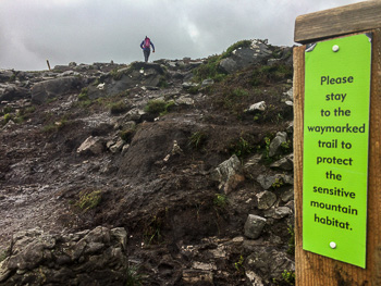
New damage caused by the sudden stop of the boardwalk near the top. Note the official sign talking about protecting the landscape - but doesn't this miss the picture of how the top got like this? Photo courtesy Paul Kellagher.
But why is it a cause for celebration that "This [the boardwalk] is amazing and after a night of solid rain the grip is brilliant"? This is a day-trip that has been downgraded from a mountain experience to something like an urban park.
Do we climb mountains because they are easy or because they are hard? Do we want to learn navigational skills and develop resilience to visit wild places or do we want the dumbed down experience on urbanised land complete with hot drinks in the car-park? Would it also be great to concrete over the top and put in showers and a coffee house?
The general landscape
And then there is the impact of said boardwalk on the actual landscape of this highly significant mountain, the highest in Cavan & Fermanagh, in the Breifne mountain area and the highest on the Border between NI and the Republic. There are various places in Ireland and elsewhere where there are successful walkers' tracks to protect landscapes. The best are carefully constructed from stone with a durable natural surface. There are good examples in the very high traffic areas of the Mournes. While such tracks do require a considerable construction phase the outcome is something that is unobtrusive and lasts a long time (unlike boardwalks).
In the video section of this newsletter there are drone views of the boardwalk. Ignore the unreflective social-media approach of the video, to see the extraordinary impact the boardwalk has. Effectively it is a stairway on an open mountainside starkly different in colour and destroying the natural unblemished look. Do we want this mountain and others like it to be covered in obtrusive woodwork? What was it we were coming to the mountains for, was it natural views and wild landscape or was it a park experience?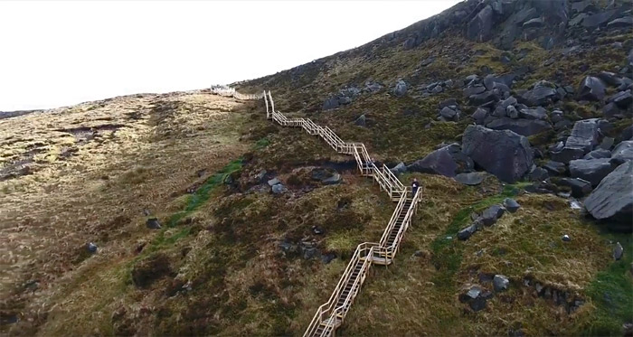
Drone view of the highly obtrusive boardwalk complete with sides and staircases. Photo: Still from Youtube video by Dezso Toth
Is it MountainViews position that only an elite that should visit Irish hills?
MountainViews vision is "Walking, Wilderness, Wonder". MountainViews is strongly in favour of more people self-reliantly visiting the mountains and we share information and promote lists & gamification to encourage many ways up many places. Cuilcagh can be considered one of 273 Vandeleur-Lynams or 27 County Highpoints. Overall we recognise the potential damage so describe over 1500 summits to spread footfall.
This situation
Due to the construction of an easy access track with unlimited usage permitted, the area at the top end of the structure has been badly damaged by footfall, and the route from there to the summit (approximately a kilometre) also shows evidence of over-use.
Also we understand that there are so many cars on the road that farmers could not get their cars up the road in lambing season. Buses got stuck such was the press which would have meant emergency vehicles being unable to get there either. Apparently the local Council is now paying a security company to manage the traffic.The top area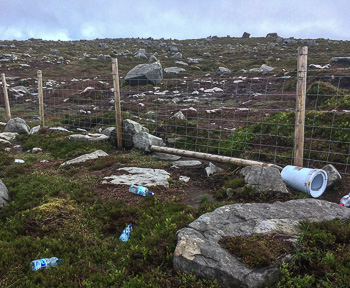
Rubbish all over the top. Photo courtesy Paul Kellagher.
Returning to the top area. In former years I visited this place on 3 occasions once from the Marble Arch side and twice from the Cavan side. I remember it as a quiet place with interesting rock formations - certainly no rubbish. From the Cavan side there is the magnificent and unusual curved scarp from Benbeg. From the Fermanagh side there are highly unusual sink-holes. But now look at some of the accompanying photos to see the damage and the rubbish. About the latter Mountaineering Ireland President Paul Kellagher and their Hillwalking, Access & Conservation Officer Helen Lawless were up there recently and removed 2 large bin liners full of rubbish. Apparently also the Council are removing rubbish 3 times a week now from the top. There aren't many mountain places in Ireland north or south anything like this and certainly not created recently.
Let's ask again, why is it so great to be doing skill free walking through a newly degraded rubbish strewn landscape?
This article and opinion in it is from MountainViews Newsletter.
Thanks to MI for some of the information in this article. We are glad to hear they are engaged with the relevant authority, the Geopark (Fermanagh District Council and staff of the Marble Arch Caves Visitor Centre) and intend to issue a statement after their next visit up there. Some photos courtesy Paul Kellagher.
Comment on this article is welcome within the usual rules on our Motley Views general forum.
Other places you could visit near Cuilcagh which have Walking, Wilderness and Wonder.
Information on visiting these places and over 2200 other summits, islands and coastal hills on MountainViews.ie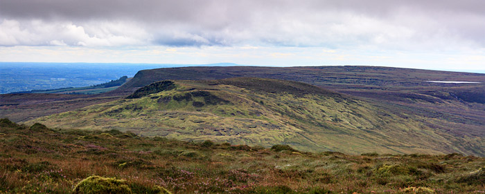
Just to the south of Cuilcagh are the Benbracks with an interesting scarp walk - you'll need skill to get there but the reward is wildlife, great views and a sense of getting away from hustle and bustle to a near wild place. Picture taken on 26th Aug 2017 from Benbeg.
You CAN visit Cuilcagh without the rubbish experience (except the top) from the southern side via Benbeg. Photo Simon Stewart.
And finally, this is what our cartoonist made of it all.
Strengthening the MountainViews Committee
Currently we have a number of officers on the committee such as chairperson, secretary etc. We really could use some further committee members to achieve our strategic goals and spread the load.Position In Brief Ordinary members For those taking an interest in the MV committee or indeed committees in general we can also use some further "regular" committee members without a specific role. There are many smaller quite finite projects that might suit regular members. Talks Group Not strictly speaking part of the main committee but an interesting position. The MountainViews ANNUAL, 2016.

In February 2016 MountainViews was delighted to announce something new, our first ANNUAL, an online magazine for Hillwalkers in Ireland. Here is our latest annual, published in Feb 2017
Click here for the current ANNUAL (or Hi-res version.)
If you are interested in a printed version you can buy one here. Click Here.CHALLENGE
A place for those interested in Challenge WalksChallenge Walk Calendar
Challenge Walk Notes for August 2017
It's not often that I'm wrong, well at least no more than 9 times out of 10 . . !
So when I didn't add the Fei Sheehy Challenge to the rankings on the Challenge Walks FAQ page (which hosts and names, the toughest of the Challenge Walks within the Calendar) - I have to admit, I was more than surprised to hear of the odd muted consternation in the odd hillwalking corner . . . .
To be fair, I will always take on board suggestions before I dismiss them!
So why the omission in the rankings? Primarily because the Challenge itself encompasses three different (and already recognised) Challenge Walks over three individual days.Also and no doubt, understandably, I have to be able to stand over that to which I may profess . . . so having never previously participated in the Fei Sheehy . . .
Fei Sheehy Challenge, Day 2.
So was this fair . . ? In the grand scheme of things - most probably not! But this year I was available and trotted down to Dungarvan where I would set up base so as to have a good command of the three day Challenge.
To best a Challenge Walk is always going to be a serious ask. The given date of the event will have been cast in stone, so to put it simply . . . it's tough tit if the day is chucking down the rain, especially if (weather-wise) it was sunshine and buttercups the day before. Now with the Fei Sheehy Challenge, absolutely everything has to fall into place for three tough days in a row!! Does this mean three different sets of Walking gear? Does it mean more than one pair of boots? Even breakfasts and dinners have to be carefully thought through cause the system can quite easily "crash" if one too many fun-size mars bars are enjoyed!!
Jim Holmes' report on this year's Fei Sheehy Challenge can be enjoyed here . . . /cms/mv1/node/107
The first of the day's adventure was a whiteout trudge with only one hour of sunshine and then heavy rain. This was the Comeragh traverse. The following day was much nicer as the Galtees were crossed. The third day however was truly savage with no hiding place as wind and rain battered the Knockmealdowns.
And so following on from the great Challenge that was . . . the Fei Sheehy Challenge now has its own "special" ranking on the Challenge Walks FAQ page!!
/FAQ/challenge/August saw Galway Walking Club report a very successful Marathon Walk Western Way and SpartanRedsox Hillwalking hosted the ever popular Mourne Seven Sevens.
Fei Sheehy Challenge, Day 3.
Near on three hundred participants successfully completed this tough Challenge that climbs the seven highest peaks in Northern Ireland and traces the Mourne Wall. Muddy and swampy conditions were testing as was the inclement weather . . . but it was the relentless attack of Midges from Hell that was the true test of resolve for all.
Taking place next weekend is the Burren Peaks Walking Festival as hosted by Ballyvaughan Fanore Hillwalking Club. There is a choice of Walks over the very special Burren landscape.
This is a great example of how a local Hillwalking Club has liaised with private land owners so as to allow for a wonderful Walk through some of the most incredible landscape in Ireland.
Na Sléibhte Hillwalking Club
And finally special mention must be given to Na Sléibhte Hillwalking Club.
What a brilliant idea . . . a core group of top officers have set up a new Hillwalking Club specialising in Challenge walking . . .
"The idea is to offer members strenuous walks across mountain ranges throughout Ireland as opposed to being based in one particular area. We are thinking of 12 hikes per year and hope to get some 'locals' to assist with routes, etc. We are in the early stages but hope to be up and running in the near future".
You can follow Na Sléibhte Hillwalking Club on Facebook or contact their PRO Gerard Sheehy to register your interest.
So boys and girls . . . keep safe and enjoy your Hillwalking. The Challenge Walks Calendar will return full throttle in the New Year - so in the meantime keep up your strict regime of serious training!! Go easy on the mince pies (not mentioning the "C" word) and let no-one return with the excuse "Let's just say that I Wintered well"
Onwards and Upwards,
Jim Holmes.
Also take a look at this resource managed by MountainViews:
www.facebook.com/ChallengeWalksIrelandemVee-Tube
Videos this month: 
A short and sweet Mournes timelapse, from member gerrym 
A paraglider flight over the Ring of Gullion, from YouTube user Tony Davis 
Drone and GoPro footage of the controversial walkway up Cuilcagh, from YouTube user Dezso Toth. We include this video not because we support the boardwalk but because for an informed discussion people need to be aware of the impact this huge development has on the landscape.
Videography by Peter Walker.SITE NEWS
SOSProgress on technical assistance
We have had to bring back our SOS looking for technical support. After great work a developer has left for Germany.
We now have much better facilities for volunteer software developers. To support group software development various tools are required such as Version Control, Issue Handling, Documentation Repository. We have moved our version control from an earlier tool, SVN to Git and Gitlab. Latter mentioned tool also supports issue handling and documentation.
If you wish to discuss taking a hand and have skills useful to a website such as MountainViews, get in touch (with no committment) at admin -at- mountainviews.ieSUMMITEERS and PLACE-VISITORS CORNER
A place for those interested in Summiteering, Bagging, Highpointing, visiting islands and coastal places.33 Coastal Hills added for Co Mayo
If you are interested in the coastline and places of interest near the coast then you can find a further incremental addition to our coastal hills, this time for Mayo. Already our adventurous member sandman has visited a number of them, for examples:
Erris Head Hill
It's the sort of place, like many in Mayo, that could be interesting to visit as part of a much longer coastal walk. sandman on Erris Head Hill, (Cnoc Ceann Iorrais): Coastal Hill
Erris Head Hill is the highest point on the Erris Head Loop walk which starts from the car park located at F7055439572. This is a family friendly walk suitable for all ages and fitness levels which makes it a popular choice among visitors to the area. ... Click here ...
or Benwee NE Head
This very dramatic top will require a scrambling approach. sandman on Benwee NE Head, (An Bhinn Bhuí): Coastal Hill
It is easy to reach the area i took the photo from just a slight detour off the Benwee Loop Walk F8220244947 it is the next bit that the problem arises. Definitely an Ian Miller summit. ... Click here ...
A Guide to Ireland's Mountain Summits - The Vandeleur-Lynams & The Arderins
MountainViews first book available online and in some bookshops. The first reprint with numerous minor amendments is available.
{{item=sggst6746}} Bulk sales to groups such as Scouts/ Guides: contact admin@mountainviews.ie for a discounted price.This month.
Kudos to our contributors.We welcome the following new members who enrolled this month. 23619e, 87micqui, adrianburke, adrianrt, aifric_n04, akilroy, andreos97, AndyFly, asalevi, AuQone, Ballinderry, Bannerman, baparent, bcahalin, Beckers, Beetle72, Berreggnog, bhattacharya59, Bigphilly, bkcullen, Boho_Hobo, Boots90210, Brona, Brrt12, btongminh, carl15jul04, CarolD, carolmon, Charleslib, Chester, chnloveCom, clenehan, clionakimber, colin01, colinmcw, colliemcc, conorjob, Corkolano, coxcox, cquinn, Cullenni1, damit, Dattache, Deccy1, Dellab, DonnachaWoods, Dreamer, drizzt, EamonnC, eamonntoner, eefii, eimearshannon12, fiefdom, freilandtone, Galisbg, Geekyjay, GeorgeHig, gerbluett, Gerhanlon, GillianPigott, gohagan, Guzzimc2, Hani, hartynm, Hazza1969, Helencrowley, Hill-Billy1602, Hjonna, Holliety, Ianc77, Idratherbewalkin, IvanRigney, JefferyIceme, jimmycottrell43, Jiri_B, jmcunningham, joebryan2, johnkforsythe, jonasbrandt, jpuigsegur, jsg2307, JuliaG, Jurgs, kalli66, Kant-hill-walk, Kanturk-Climbers, KarenMi, kathleenhealy, Kev1990, kluc, ladyhawke1003, Lara, Lewyki, Liamob, Ligind, liz1, lizjennings, Lmoroney, lmullee, lob1975, M-aire, MadraRua72, Magda_lena, Mahonm, MarianH, MarieK, Markcn, Markmcl88, mauriced, max83, Mcarr77, Meanoldmike, MichealMac, mickaleenus, mickos, Mike-Mor, mkrasnow, Mmcc, Monicadoherty, monicaliam, mountainderek1, Mtwalks322, murraypeter, Mushera4, nathalington, Nedbro, Nollaigh, nzpengweng, OLoinsigh, omoblue, oregang, Owenloughrey, OwenP, p.mcgowan1, paddyt, Pat-Molan, Patmca17, patrickfoley, Paul1972, PaulNolan, Paulpatrick, Paul_H, peterwright, pierrot67, pjierland, pl, pwbellarby, qpidnetworkCom, Rannmor, Rayjam, RaySpain, reespdr, RichG, Romary, Sao, sbarry100, scarecrow, seanwhowalks, Sea_Hare, shadesmalone, sheilakilduff, Shuby, Sidhe, Simon21a, simoncaldwell, simong, Smargey, Smokey, Spenceralure, Steve.gannon123, Sunwalker, sussexdon1, temp, Tobi, Tomaszek, TonyRuddy, tortoise, urckle, Vils, Viviansheehan, Westcountrygirl, williamoconnell, WillowKerry, wohfnow, wwa, Xiom5724 (186)
Our contributors to all threads this month: Aciddrinker (2), Anthony (3), BarnaneGoat (1), Bunsen7 (10), Colin Murphy (1), ColinCallanan (1), David-Guenot (12), GSheehy (3), IainT (6), MountainBoy (1), Onzy (7), Pepe (4), Peter Walker (11), Tobi (2), TommyMc (1), TommyV (1), Wilderness (1), andreos97 (1), bryanmccabe (3), coublevie (1), davsheen (4), dmcdevitt (1), dr_banuska (2), fieldoptic (2), fkaatje (2), gaoithe (2), giomach (1), Communal summary entries (3), jackill (3), jkforde (1), jpuigsegur (1), ladyhawke1003 (2), liz50 (2), madfrankie (2), markwallace (1), marzka (5), mcrtchly (2), melohara (1), mickhanney (1), oakesave (1), pazapas (1), peter1 (3), roscorrocket (1), sandman (44), scarecrow (3), simoburn (25), simon3 (21), skhg (4), t.prewitz (1), thomas_g (4), tomodub (1), truescot (1), whoRya (1), wicklore (6)
For a fuller list view Community | Recent Contributors
There were comments on the following places , Abbey island, An Cheathrú Lair, Ardagh, Ardbear N, Ballinacorbeg, Ballinafunshoge, Ballyguile Hill, Ballyteige, Barnacuillew E.Top, Barnavave, Barr na Coilleadh, Barranisky, Beann na Stiocairí, Ben Beg, Benard, Benwee NE Head, Binn Mhairg, Bruse Hill, Carrigeen Hill, Church Island, Clermont Carn, Cnoc an Diaraigh, Cnoc Lios Uachtair, Cnoc Mordáin, Cone Hill, Corraduff Hill, Crenville, Croaghaderry, Crockawama, Crocknaneeve, Croghan Hill, Cuilcagh, Curra Hill, Dawros More North, Dereenavurrig Hill, Derryadd West, Derrygimlagh West, Doire Uí Fhríl, Doon Hill, Doonvinalla E Top, Doonvinalla N Top, Doonvinalla W Top, Erris Head Hill, Faul, Galtymore, Geevraun Point, Glendorragh Point Hill, Gooreen, Great Saltee Island, Horse Island, Hungry Hill, Illanbaun Hill, Illanmaster, Inis Ní, Ireland's Eye, Keadeen Mountain, Kilcommon Hill, Kilgalligan Hill, Knockanallig, Knockavoe, Knockboy, Knocknacusha, Knockshanbo Hill, Lackan Hill, Mannin Beg, Mauherslieve, Maum, Maumtrasna, Mountpelier Hill, Mullaghmeen, Mullaghnacross Hill, Murvey, Raheen, Rossmore Island, Seanadh Bhéara, Shanboolard, Sheegouna, Slieve Foye, Slieve Na Calliagh, Temple Hill, The Eagles Rock, Tomies Mountain, Tonelagee
and these shared tracks An Corrán, Dunkerron Mountains Ireland, Austria, Tyrol , Austria, Tyrol , Austria, Vorarlberg , Austria, Vorarlberg , Austria, Vorarlberg , Austria, Vorarlberg , Ballinastraw, Dublin/Wicklow Ireland, Barranisky, Dublin/Wicklow Ireland, Beinn Sgritheall East Top, Glen Shiel to Loch Hourn and Loch Britain, Ben Lugmore East Top, Mweelrea Mountains Ireland, Benard, Galty Mountains Ireland, Bencorrbeg, Twelve Bens Ireland, Bengorm, North Mayo Ireland, Binn Chaonaigh, Maamturks Ireland, Bolehill, Lancashire, Cheshire & the Southern Pennines Britain, Brides Hill, Wicklow Coastal Hill Ireland, Camaderry South East Top, Dublin/Wicklow Ireland, Carrauntoohil, MacGillycuddy's Reeks Ireland, Carrignagower, Comeragh Mountains Ireland, Cnoc na dTarbh, MacGillycuddy's Reeks Ireland, Collon Hill, Dublin/Wicklow Ireland, Comeragh Mountains Ireland, Coomcallee, Dunkerron Mountains Ireland, Corcóg, Maamturks Ireland, Cork Islands Ireland, Cork Islands Ireland, Croaghacullin, Donegal SW Ireland, Croaghavehy, Donegal SW Ireland, Dartry Mountains Ireland, Donegal Islands Ireland, Dublin Islands Ireland, Fauscoum, Comeragh Mountains Ireland, France, Occitanie , France, Occitanie , France, Occitanie , France, Occitanie , Germany, Bavaria , Germany, Bavaria , Germany, Bavaria , Germany, Bavaria , Germany, Bavaria , Germany, Bavaria , Germany, Bavaria , Germany, Bavaria , Germany, Bavaria , Germany, Bavaria , Germany, Bavaria , Germany, Bavaria , Germany, Bavaria , Germany, Bavaria , Germany, Bavaria , Germany, Bavaria , Germany, Bavaria , Germany, Bavaria , Germany, Bavaria , Glendoo Mountain, Dublin/Wicklow Ireland, Ireland's Eye, Dublin Islands Ireland, Keamconneragh, Glenbeigh Horseshoe Ireland, Knockanamadane, Dunkerron Mountains Ireland, Knockmealdown Mountains Ireland, Knocknalougha South Top, Knockmealdown Mountains Ireland, Knockroe, Blackstairs Mountains Ireland, Knockshanahullion, Knockmealdown Mountains Ireland, Knocksheegowna, Comeragh Mountains Ireland, Lancashire, Cheshire & the Southern Pennines Britain, Lugnaquilla, Dublin/Wicklow Ireland, Na Cnámha, MacGillycuddy's Reeks Ireland, Na Cnámha, MacGillycuddy's Reeks Ireland, Nephin Beg S Top, North Mayo Ireland, North Wexford Ireland, Shannon Ireland, Sleamaine, Dublin/Wicklow Ireland, Slievanea NE Top, Central Dingle Ireland, Slieve Carr, North Mayo Ireland, Slieveanard NE Top, Galty Mountains Ireland, Slievenamon, South Midlands Ireland, Stoompa, Mangerton Ireland, Stuc a'Choire Dhuibh Bhig, Loch Torridon to Loch Maree Britain, Stuc Loch na Cabhaig, Loch Torridon to Loch Maree Britain, Sugarloaf, Dublin/Wicklow Ireland, Temple Hill, Galty Mountains Ireland tracks were created.
Thanks to all 1298 who have ever contributed place or routes info and forums.
For a full list view Community | Contributors Hall of Fame
Summary. MountainViews now has 8497 comments about 1584 different hills, mountains, island and coastal features out of the total in our current full list (2121). We want to get a good gps track showing each of the major ways to visit each of these places and summits in Ireland. If you see an option to add a "Short Summary" then do please consider creating one since another objective is to have a short summary for every summit and island and coastal feature in Ireland. There's a few (537) opportunities for you to be the first to comment on a summit, however lots of opportunities for islands and coastal features as we bring them out. We also have around 1900 shared GPS tracks, mostly in Ireland. Apart from a few popular areas, there is a need for more routes in many different areas. Plain shared tracks without descriptions are welcome however if you have time then do please add route descriptions with photos.NOTICES
Notices - If you are contributing, please be careful to respect the interests of landowners. Suggest access routes well away from houses, gardens or that could conceivably impact farming activities. When walking, keep away from gardens or farm buildings. Use stiles or gates wherever possible. Never do anything that could allow animals to roam where the farmer did not intend. Ask permission where appropriate.
- Report suspicious activity to the police forces, as below.
- If your car is broken into in an upland area report it to the PSNI or Gardai as this will help them be aware of the issue and tackle it in future. Store the numbers. In Northern Ireland use the PSNI non-emergency number 0845 600 8000. In the Republic you can find the local Garda District HQs phone numbers at www.garda.ie/Stations/Default.aspx. Specifically for the hotspot of Wicklow: the Garda Divisional Headquarters in Bray is 01 6665300.
- If you hear of a problem area or route, write it up in MountainViews
which does everyone a service.
Report rubbish tipping in the Republic - ring EPA hotline 1850 365 121
Report recreational quads in national park area (in which they are banned). They are also banned in the Mournes. For Wicklow please phone the Duty Ranger: 087-9803899 or the office during office hours Telephone: +353-404-45800. For the Mournes ring the PSNI (as above) or contact Mournes Heritage Trust. Put these numbers in your phone, take regs etc. Let MV know of contact numbers for other areas. - If you have visited some of the less well known places, we would appreciate a place rating and also "Improve Grid Ref" for summits and other places.
- If you find errors in the basic information about places such as in their names, their heights, county name etc please use the "Propose Places Database Change" option.
- If we can, let's make MV have more than one route up a summit or to a place so as to reduce the tendency for paths to appear. Your grid refs in comments for different starting points show up on MountainViews maps as well as shared GPS tracks.
-
 Visit the MountainViews Facebook page.
-
Visit the Challenge Walks Ireland page (jointly managed by MountainViews)
This newsletter
This newsletter Editor: Simon Stewart, Homepage: www.simonstewart.ie
Assistant editors: Colin Murphy, David Owens
Summit comment reviews: David Murphy
Challenge Info: Jim Holmes
Track reviews: Peter Walker
Book reviews: Aidan Dillon, Peter Walker, Mel O'Hara
Videography: Peter Walker
Graphics design advice: madfrankie
Development & support volunteers: Vanush "Misha" Paturyan, Jack Higgins, Piotr StepienNewsletter archive. View previous newsletters mountainviews.ie/newsletter RETURNING TO MOUNTAINVIEWS Click on (If you have cookies on in your browser then you will be prompted as to username/ password. If you forget the password, the login page can email you a replacement.) UNSUBSCRIBING If you don't want to receive any further monthly newsletters from Mountain Views click on Settings. Then change the option beside "Include on occasional mailing list" to "Do not include". Then click the "Save" button.
Alternatively let us know by email at admin -at- mountainviews.ie Include the email address you got this at or your screen-name guestuser.