This website uses cookies, which are small text files that the website puts on your device to facilitate operation. Cookies help us provide a better service to you. They are used to track general user traffic information and to help the website function properly.
Feature count in area: 9, all in Mayo,
OSI/LPS Maps: 37, MSW
Highest Place: Barrclashcame 772m
Starting Places (18) in area Sheeffry Hills: Aasleagh Waterfall CP, Ben Creggan N, Delphi Resort, Doo Lough N, Doo Lough SE, Glencullin Lough CP, Glendavock, Glennacally Bridge, Glenummera River, Laghta Eighter, Laghta Eighter Hill NE, Otter Pool, Owenduff River, Paddy's Place, Sheeffry Pass, Sruhaunpollanoughty, Tawnyard Lough, Tawnycrower
Summits & other features in area Sheeffry Hills: E: Glenlaur: Laghta Eighter Hill 388m, Tawny Rower 510m, Tawnyard 436m, Tievnabinnia 742m, Tievnabinnia East Top 590m, Tievnabinnia SE Top 525m W: Doo Lough: Barrclashcame 772m, Barrclashcame North-West Top 580m, Tievummera 762m
Note: this list of places may include island features such as summits, but not
islands as such.
Barrclashcame, 772mMountain Barr Chlais Céim A name in Irish,
Place Rating ..
(prob. Ir. Barr Chlais Céim [PDT], 'top of Clais Céim or the trench of the step'), Barracloshcame, Mayo County in Connacht province, in Arderin, Vandeleur-Lynam, Irish Highest Hundred Lists, Barrclashcame is the highest mountain in the Sheeffry Hills area and the 62nd highest in Ireland. Barrclashcame is the second most westerly summit in the Sheeffry Hills area.
Grid Reference L84951 69515,
OS 1:50k mapsheet 37 Place visited by: 221members, recently by: Jimmy600leavey, rhw, finkey86, taramatthews, srr45, Carolineswalsh, Damian120, ToughSoles, Niamhq, bryanjbarry, Carolyn105, Beti13, Krzysztof_K, NualaB, geohappy
I visited this place: NO (You need to be a logged-in member for this.)
Longitude: -9.740786, Latitude: 53.662892, Easting: 84951, Northing: 269515,
Prominence: 707m, Isolation: 1.2km ITM: 484952 769534 Bedrock type: Mudrock, sandstone, tuff, (Sheeffry Formation) Notes on name: Clashcame is a townland name, interpreted by John O'Donovan as Clais Céim, 'trench of the step'. This seems to relate to the name Cuscamecurragh, which on Bald's map of Co. Mayo (1830) refers to part of the high ridge of the Sheeffry Hills (see Tievummera). Clashcame is situated at the western foot of this ridge. Barrclashcame is the top part of the townland. Previously Clashcame in MV. Walks: for a route along the main E-W ridge of the Sheeffry Hills, see Whilde & Simms, New Irish Walk Guide - West and North, 62-63.
Short or GPS IDs, 6 char: Brclsh, 10 char: Brclshcm Linkback: https://mountainviews.ie/summit/60/
Gallery for Barrclashcame (Barr Chlais Céim) and surrounds
Summary
for Barrclashcame (Barr Chlais Céim):
Grassy, steep-sided flat top with mesmerising views
Summary created by markmjcampion, Colin Murphy
2023-08-18 16:13:51
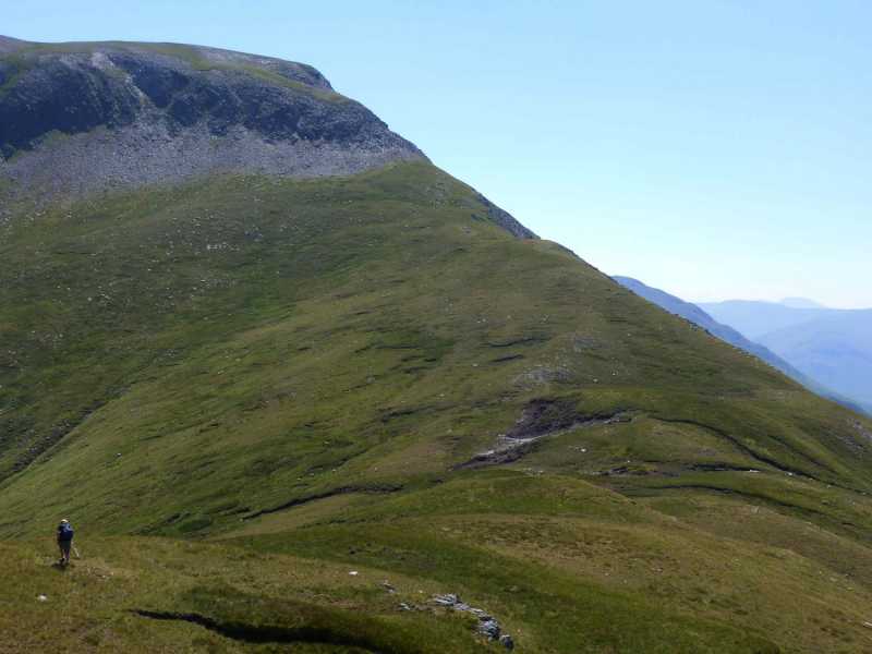
Picture: The steep, rocky ascent from the north west
Barrclashcame sits at the W edge of the Sheffreys in a remote part of SW Mayo. The Doo Lough valley is to the W and B. has impressive bulk when seen from the road to the S. Views are widespread incl Croagh Patrick, Ben Creggan and Mwelrea and various lakes and islands.
W. Park near A (L82385 69866) and be prepared for an immediate battle with the non-horizontal! There's a relentless steep pull to the NW top but the nature of the terrain is favourable - a grass/rock mixture. Drop down to the col and now it's a steep climb to the summit. En route there's a very steep band of rock - an easy scramble but care should be taken in bad weather. Once through the rock, turn NE for a gentle ramble of 500m the summit cairn, which sits amid a broad, featureless grassy area. Allow 2.5 hours.
E. Barrclashcame is often combined with other Sheffry hills. There are many approaches to the ridge - from a coillte plantation [track starts at GlUmer R (L87210 67479)], from to the E of Tawnyard at Shef Ps (L92086 68632) or via the Western Way at TCrower (L91997 69722). Each route will eventually see you taking the ridge to the W of Tievummera which is a short, airy concern with steep ground on both sides, It's easy going from T. to the summit of B. but navigation skills need to be good here in poor weather. From B. descend either v steeply on grassy ground to the SSW or reverse the route to the N described above.
Notable tracks include track/3853, track/3744, track/3731 and track/2951. The latter two involve car splits.
Clashcarne is a massive hill with steep green slopes rising from near sea level at Doo Lough. I reached from the col with Tievummera (see for previous part of east to west traverse) by quite a narrow little ridge and a short climb above steep southern slopes. The top is flat with short grass and there is a small cairn with views back along northern flanks of preceding hills. A short walk to a little upright stone finds the western end of the Sheefrys and perhaps the best views of the whole range - across Doo Lough to Mweelra (see pic). Voices could clearly be heard floating up from cars parked on the road over 700m below but there was no one else up here and you just felt on a different world.You could spend the whole day here just taking in the view stretching from Doo Lough to Finn Lough between the steep slopes of Ben Gorm and Mwreela and across across Killary Harbour to the 12 Bens. To the north and west the ocean is dotted with numerous islands. I dropped down NW to take in the North West Top over some very steep and rocky ground requiring use of hands - just under an hour there and back up. To ascend off the hill drop down south over relentlessly steep ground which is slippery in places. The view down into the valley and across to Ben Creggan helps to ease the strain on the legs as descend heading for one of the two bridges over the Glenummera River - I contoured down east for the second bridge but was able to cross the river easily before this. It is then a walk of just over 3 miles back to the starting point at the forest entrance above Tawnyard Lough. I did not see anyone else on this traverse of the Sheffreys and would thoroughly recommend it as a full day but only when the weather is good. Linkback: mountainviews.ie/summit/60/comment/1116/
Read Less
Read More
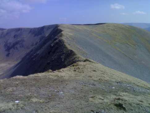
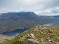
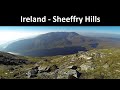
Picture: Part of the fantastic Sheeffry ridge
wicklore on Barrclashcame
by wicklore
10 Sep 2008
This photo, taken from near the summit of Barrclashcame, shows the ridge between Tievummera and Barrclashcame. The cliffs below Tievummera can be seen beyond the ridge in the foreground. Linkback: mountainviews.ie/summit/60/comment/3299/
Read Less
Read More
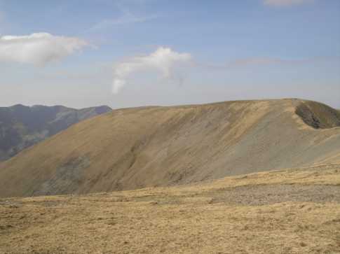
Picture: View of the summit plateau of Barrclashcame
wicklore on Barrclashcame
by wicklore
21 Sep 2008
This is a photo of Barrclashcame taken from Tievummera. The steep ridge leading from Tievummera to Barrclashcame can be seen on the right, and the Ben Lugmores of the Mweelrea range are visible beyond Barrclashcame to the left. Linkback: mountainviews.ie/summit/60/comment/3330/
Read Less
Read More
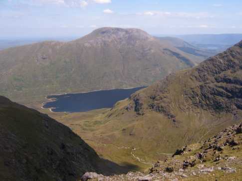
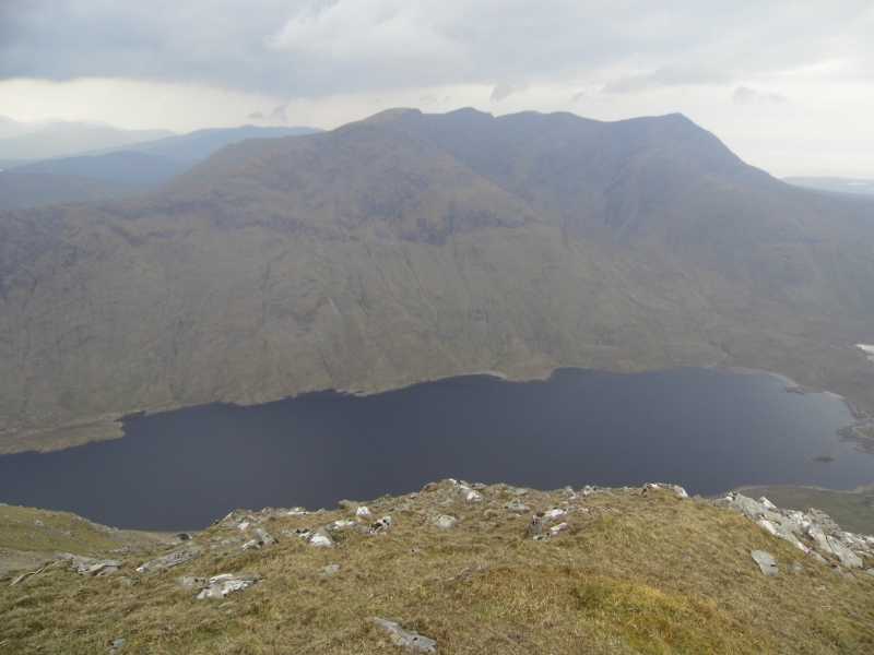
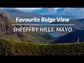
Picture: Looking down on Doo Lough with the famous ramp in the Mweelrea range behind it
Great ridge walk
by TommyV
20 May 2019
Parked at the spot mentioned by weedavie at DooL SE (L84489 67685). I followed the road along the Sheefrey pass for about three kilometers. You will come across a Coilte forest which has a road that zig zgs up the hill through the forest. On the last zag the open mountain is on your left. There is a few hundred metres of felled trees to contend with but its not nearly as bad as it looks. After this you will be on the shoulder of the spur leading up to the trig point on Tievummera. Now the hard work is done it's time to enjoy the stunning views and the ridge walk over to Barrclashcame. About 500 metres South West of here there are superb views of Doo Lough and the Mweelrea range. From here I dropped back down to the Southern end of Doo Lough back to the car. Note the ground here is very steep and if it's any way wet I would suggest heading over to the North West top and drop down to the famine memorial instead. It's easy to follow the road from here along by the lake. Linkback: mountainviews.ie/summit/60/comment/20532/
Read Less
Read More
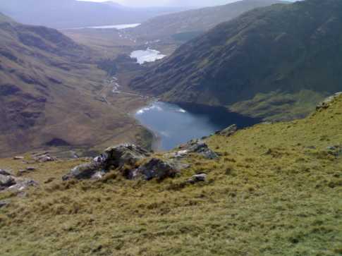
Picture: View south from Barrclashcame
wicklore on Barrclashcame
by wicklore
10 Sep 2008
This photo was taken standing at the southwestern end of the Barrclashcame plateau. There is a great view south over Doo Lough, Fin Lough and beyond to Killary Harbour. The lower slopes of Ben Creggan are to the left and the Mweelrea Mountains to the right. Linkback: mountainviews.ie/summit/60/comment/3300/
Use of MountainViews is governed by conditions and a privacy policy.
Read general information about the site. Opinions in material here are not necessarily endorsed by MountainViews.
Hillwalking is a risk sport. Information in comments, walks, shared GPS tracks or about starting places may
not be accurate for example as regards safety or access permission. You are responsible for your safety and your permission to walk.
See the credits and list definitions.


 Our Facebook page.