If you want to use the website often please enrol (quick and free) at top right.

Cairn Gorm 1244m, Cairn Lochan 1215m, Stob Coire an t-Sneachda 1176m, Cnap Coire na Spreidhe 1150m, Fiacaill a'Choire Chais 1141m, Fiacaill Coire an t-Sneachda 1122m, Bynack More 1090m, Fiacaill na Leth-choin 1083m, Creag an Leth-choin [Lurcher's Crag] 1053m, Sron a'Cha-no 1028m,
 Get Notifications
Donations Drive, now finished.
Binnion: Tullagh Bay and Rockstown Harbour
 Jim_Brady
Crocknapeast: Long walk up windfarm roads.
 Collaborative entry
Good, relatively easy double bag
 Colin Murphy
Mulnanaff: Longish walk up windfarm road.
 Collaborative entry
Double bag mostly on windfarm tracks.
 Colin Murphy
Binbane NE Top: Simple bag from its neighbouring top.
 Collaborative entry
Lake District: Dale Head Horseshoe
Binbane: Steepish approach to relatively easy Carn.
 Collaborative entry
Lake District: Coledale Horseshoe
Crucknaree: Magnificent views!
 paddyhillsbagger
Dunranhill: Sika deer and sitka spruce
 hibby
hibby
Use of MountainViews is governed by conditions and a privacy policy.
Read general information about the site.
Opinions in material here are not necessarily endorsed by MountainViews.
Hillwalking is a risk sport. Information in comments, walks, shared GPS tracks or about starting places may not be accurate for example as regards safety or access permission. You are responsible for your safety and your permission to walk.
See the credits and list definitions.
 Visit our Facebook page.
 Length: 26.7km, Creator time taken: 6h58m, Ascent: 1000m,
Descent: 996m
Places: Start at NH9839708828, Bynack More, A\'Choinneach, Bynack Beg, end at Start
Logged as completed by 1

Each approach has its merits, but the Glenmore route passes the magical Lochan Uaine. Bynack More has two associated Munro Tops, A’Choinneach and Bynack Beg. This track records a visit from the Allt Mòr car park where there is usually ample parking.
The first 5 kms to the Nethy can be cycled which, overall, saves around an hour. The track is quite rough in places though and walking through the forest is quite pleasant so using a bike is a matter of personal preference.
As Bynack More is located on the northeast periphery of the Cairngorms and a little apart from the other hills, it can provide extensive views of Cairn Gorm,
Beinn Mheadhoin, Beinn a’Chaorainn, Beinn a’Bhùird and Ben Avon.
After crossing a bridge over the Nethy, the route rises steadily along the track of an old drove trail to Braemar.
The drove trail reached the Làirig an Laoigh via the Fords of Avon.
The track forks at around NJ 039 087, and leaving it, the route continues south along the ridge, rising gently for around 1.5 kms.
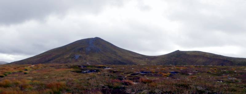
Approaching Bynack Mor and Bynack Beg from the North.
An ascent of around 180m over another kilometre follows, to arrive at the summit cairn of Bynack More, 1090m at NJ0419 0636.
The summit cairn is surrounded and partly hidden by large boulders and may need to be searched for.
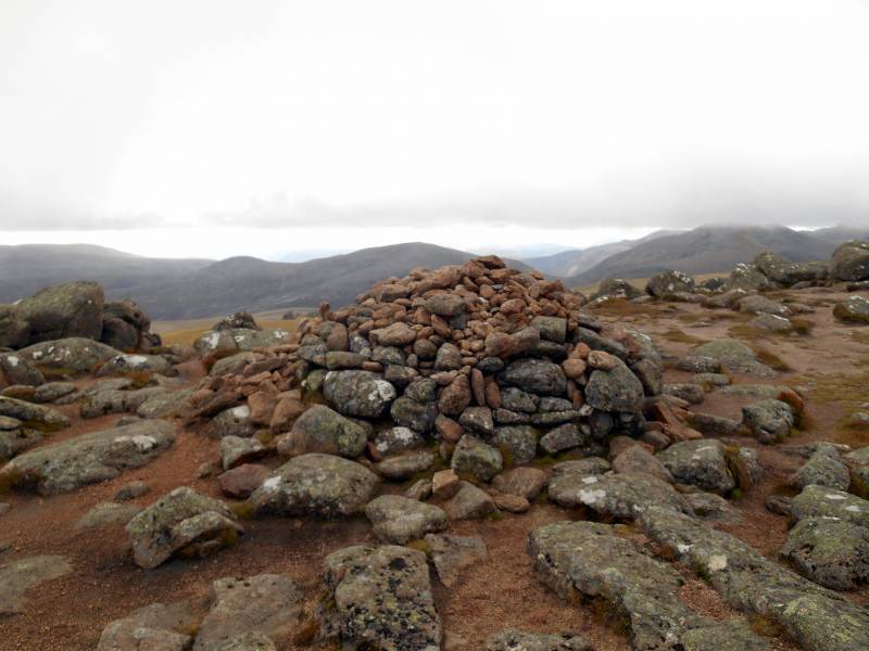 Summit Cairn Bynack Mor
Some of the steeper parts of the direct ascent path are eroded so a little care is needed, especially if descending this way.
(The path erosion can be totally avoided by visiting Bynack Beg first and returning again to Bynack Beg on the descent, as the path via Bynack Beg is not trafficked to the same extent as the main path.)
After leaving the summit of Bynack More, this route continues south passing the Little Barns of Bynack.
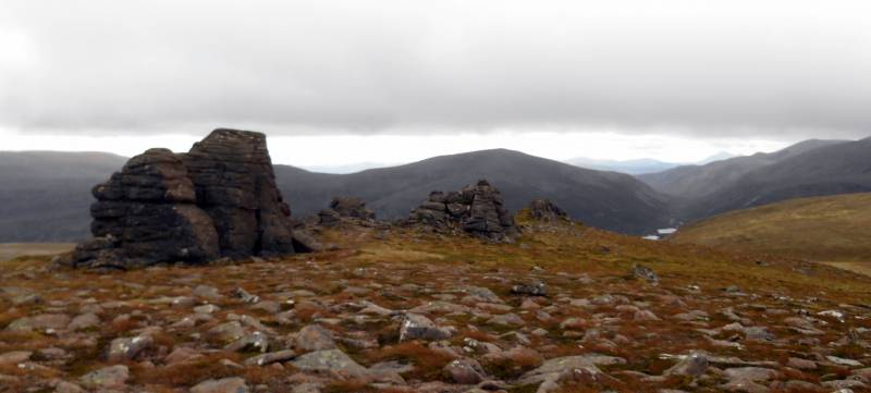 The Little Barns of Bynack with Beinn a Chaorainn beyond. On the horizon, to the right, Carn Nan Gabhar, 1121m, of Beinn a'Ghlo can just be discerned
The Little Barns of Bynack are granite tors, composed of tough granite and were left exposed as the rest of the hill, composed of softer granite, was eroded over the aeons.
The even bigger Barns of Bynack, the largest tors in the Cairngorms, are at NJ045 058, a little to the east of this route.
The route now shifts to the southwest to reach A’Choinneach, 1017m, at NJ0321 0482.Classified as a seperate mountain in Munro's original 1891 tables, it was demoted to Munro Top in the 1981 revision, along with six other eastern Munros.
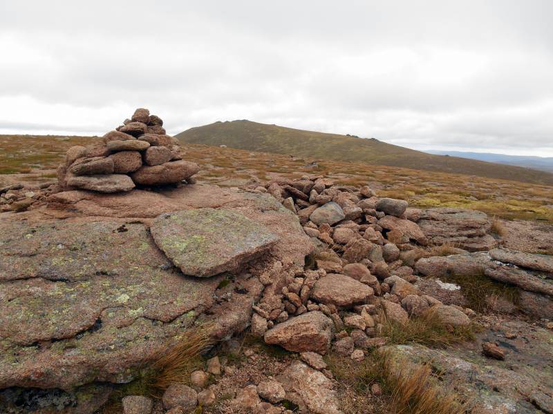
Summit cairn A'Choinneach with Bynack Mor beyond.
The route then heads towards Bynack Beg, 970m at NJ0363 0683, before returning to the outward route at around NJ040 073.
The outward route is then followed back to the Allt Mòr car park. TYM.
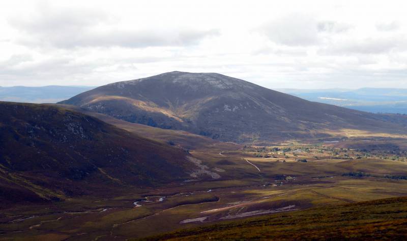
The Corbett, Meall a'Bhuachaille viewed across Strath Nethy while descending towards Ryvoan Pass and Glenmore
NOTE: ALL information such as Ascent, Length and Creator time taken etc should be regarded as approximate. The creator's comments are opinions and may not be accurate or still correct.
Your time to complete will depend on your speed plus break time and your mode of transport. For walkers: Naismith's rule, an approximate though often inaccurate estimate, suggests a time of 7h 1m + time stopped for breaks
NOTE: It is up to you to ensure that your route is appropriate for you and your party to follow bearing in mind all factors such as safety, weather conditions, experience and access permission.
* Note: A GPS Height in the elevation profile is sourced from the device that recorded the track. An "SRTM" height is derived from a model of elevations for parts of the earth. More detail![]()
|
|
|
||
| MountainViews.ie, a Hill-walking Website for the island of Ireland. 2400 Summiteers, 1480 Contributors, maintainer of lists: Arderins, Vandeleur-Lynams, Highest Hundred, County Highpoints etc | |||