If you want to use the website often please enrol (quick and free) at top right.

Ben Nevis 1344m, Sgurr a'Mhaim 1099m, Am Bodach 1031.8m, Carn Dearg SW Top [South Top] 1020m, Sgor an Iubhair 999.7m, Stob Ban 999m, Stob Choire a'Mhail 990m, An Gearanach 981.4m, Stob Coire a'Chairn 981.4m, An Garbhanach 974.9m,
 Get Notifications
Arroo from east
Auchineden Hill: Small detour to the Whangei rock feature must be included in th
 Fergalh
Double bag mostly on windfarm tracks.
 Colin Murphy
Goatfell [Goat Fell]: Long but worthwhile trek
 Fergalh
Corkindale Law: Short trek to summit
 Fergalh
Good, relatively easy double bag
 Colin Murphy
Crownarad SW Top: Crown na rad
Lake District: Dale Head Horseshoe
Knocklettragh: Knockletragh from North - school report
Mount Kennedy: Red kites in the blue sky
 hibby
hibby
Lake District: Coledale Horseshoe
Arroo Mountain: Arroo from E, partial drive in
Use of MountainViews is governed by conditions and a privacy policy.
Read general information about the site.
Opinions in material here are not necessarily endorsed by MountainViews.
Hillwalking is a risk sport. Information in comments, walks, shared GPS tracks or about starting places may not be accurate for example as regards safety or access permission. You are responsible for your safety and your permission to walk.
See the credits and list definitions.
 Visit our Facebook page.
 Length: 16.7km, Creator time taken: 8h 6m, Ascent: 1619m,
Descent: 1618m
Places: Start at NN1426368376, Mullach nan Coirean, Meall a\'Chaorainn, Mullach nan Coirean SE Top [South Top], Mullach nan Coirean East Top, Stob Ban, Sgor an Iubhair, Stob Choire a\'Mhail, Sgurr a\'Mhaim, end at NN1454368308 289m E from Start
Logged as completed by 1

Leaving the car park, walk back along the road to Fort William for 275 m, crossing a bridge, to the entrance to a forest track on the left at NN1426 6839. Follow the well signposted track through the forest to emerge at NN1326 6813 where a stile, with a dog gate beside it, helps hikers and their dogs negotiate a deer fence and access the open hillside.
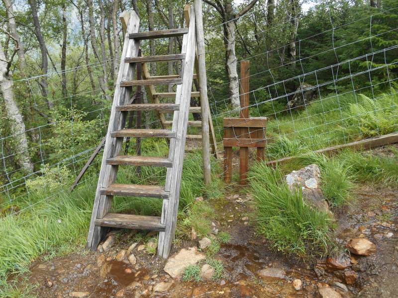
Stile over deer fence with dog gate - lifting the centreboard allows dog through
There is a steep, rough and at times, eroded and muddy path along the edge of the forest which leads onto a path along the ridge between Coire Riabhach and Coire Dearg.
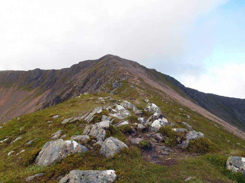
Ascent ridge between Coire Dearg and Coire Riabhach.
After ascending the ridge, a walk around the corrie rim will bring you to the large cairn marking the summit of Mullach nan Coirean, at NN1224 6623, 939m, the lowest of the Mamores.
Meall a’Chaorainn can then be visited by walking around the rim of Coire a’Mhuilinn. Stob Bán is approached by walking around the ridge above Coire Dearg, visiting Mullach nan Coirean’s two cairned tops at NN1313 6546, 918m and NN1373 6559, 917m.
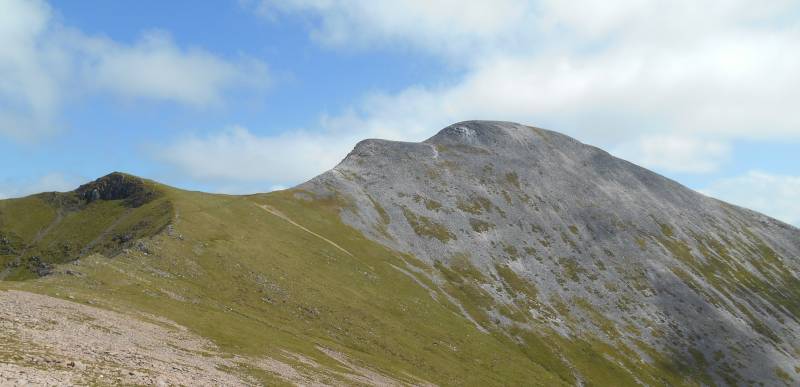
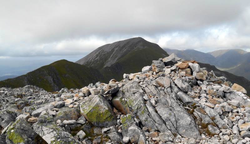
Approaching Stob Bán, 999m.
After visiting Stob Bán there is the option of omitting Sgúrr a'Mháim by descending to the col at the top of Coire Mhusgain and using a rough path on the east side of Allt Coire a’Mhusgain to reach the start point, Lower Falls car park.
The other option is to visit Sgúrr an Iubhair, NN1652 6550, 1001m, and then approach Sgúrr a’Mháim via the Devil’s Ridge.
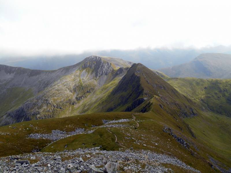
Summit Cairn of Sgúrr an Iubhair with Devils Ridge and Sgúrr a’Mháim.
Sgúrr an Iubhair was a Munro until the 1997 revision of Munro’s Tables. It is now considered to be one of Sgúrr a’ Mháím’s two tops. The other, Stob Choire a’Mháil, 990m, is located on the Devil’s Ridge at NN1633 6599.
The Devil’s Ridge is not too difficult on dry, calm days. It would be more challenging on a very wet or windy day or in snow or ice.
Looking back to the Devil’s Ridge, Stob Choire a’Mháil and Sgúrr an Iubhair.
The ascent of Sgúrr a Mháim from the Devil’s Ridge is not too taxing but the descent along its northwest ridge to the start point requires patience.
Harvey's SUPERWAKER XT25 map, Ben Nevis, Mamores and Grey Corries, ISBN 978-185137402-1 recommended for this route. Scale is 1:25,000 and the map is really tough, durable, light and totally waterproof.
NOTE: ALL information such as Ascent, Length and Creator time taken etc should be regarded as approximate. The creator's comments are opinions and may not be accurate or still correct.
Your time to complete will depend on your speed plus break time and your mode of transport. For walkers: Naismith's rule, an approximate though often inaccurate estimate, suggests a time of 6h 3m + time stopped for breaks
NOTE: It is up to you to ensure that your route is appropriate for you and your party to follow bearing in mind all factors such as safety, weather conditions, experience and access permission.
* Note: A GPS Height in the elevation profile is sourced from the device that recorded the track. An "SRTM" height is derived from a model of elevations for parts of the earth. More detail![]()
|
|
|
||
| MountainViews.ie, a Hill-walking Website for the island of Ireland. 2400 Summiteers, 1480 Contributors, maintainer of lists: Arderins, Vandeleur-Lynams, Highest Hundred, County Highpoints etc | |||