- Home
- Main Display
- Main Display (Old)
- Find a Walk
- Display INTRODUCTION
- DONATE
- Click below for your
profile & contributions
guestuserWelcome to MountainViews
If you want to use the website often please enrol (quick and free) at top right.OverviewFor more map options click on any overview map area or any detail map feature.Detail Map FeaturesShowing 20 of a total of 31 items:
Garraun 598m, Benchoona East Top 585m, Benchoona 581m, Garraun South Top 556m, Altnagaighera 549m, Doughruagh 526m, Doughruagh South Top 525m, Mweelrea SE Spur 495m, Letterettrin 333m, Currywongaun 273m,Tracks:2730, 18km 3074, 15km 2728, 13km 3159, 11km 3984, 10km 3733, 10km 5003, 10km 2726, 9km 3915, 9km 4399, 7km Find Suggested Walks
Find hill, mountain, island, coastal feature.Videos

Users Online:
garrettd, Ulsterpooka
Guests online: 626Recent Contributions
 Get Notifications
Carrauntoohil: Above the Clouds: 360 Degree Cloud Inversion
Mangerton & Stoompa
Carrauntoohil: Above the Clouds: 360 Degree Cloud Inversion
Seefin Mountain West Top: Great paths, closed boardwalk
Broaghnabinnia West Ridge and Stumpa Duloigh Traverse
Proctor High Mark: A rocking stone not a rolling one
A tough but rewarding day
Proctor High Mark: Find the gaps in the walls to find the highpoint
Clapham High Mark: Find the gaps in the walls to find the highpoint
Interesting route around Trooperstown, Wicklow.
Parson's Pulpit: Short trek to summit through Burren type landscape
Cahas Surveying: Changes to Arderins etc
Conditions and Info
Use of MountainViews is governed by conditions and a privacy policy.
Read general information about the site.
Opinions in material here are not necessarily endorsed by MountainViews.
Hillwalking is a risk sport. Information in comments, walks, shared GPS tracks or about starting places may not be accurate for example as regards safety or access permission. You are responsible for your safety and your permission to walk.
See the credits and list definitions.Video displaymarkwallace: Track 3915 in area near Benchoona, Twelve Bens (Ireland)Benchoona horseshoe from Lettergesh Beach Length: 8.8km, Creator time taken: 1h40m, Ascent: 621m,
Descent: 154m
Places: Start at L7407363014, Benchoona, Benchoona East Top, Garraun, Garraun South Top, Altnagaighera, end at L7547760872 2.6km SE from Start
Logged as completed by 3

Park at Lettergesh Beach car park. The rocky summit dome of Benchoona is already visible off to the left. Walk back up to the road and turn left. 150m further on is a little unsignposted lane going up to the right. This GPS track begins and ends at the entrance to the lane.
The lane goes past several houses then comes to a gate with a "Keep Gate Closed" sign. Go through it, and the lane continues up quite steeply to a water treatment plant on the hillside. (This is clearly visible from the road, so if the route is unclear, look for the plant and try and trace the lane down from it.)
Past the water treatment plant, the lane turns into a grass and gravel track. Soon it comes to a second gate, this one bearing a "No dogs allowed" sign. Go through the gate, unless you have or are a dog. The track continues with a stream with very steep banks on the right. After just a minute or so, the track crosses the stream via a sturdy concrete bridge. Don't cross the bridge, but head off the track and to the left to Benchoona,
whose rocky dome (not really a dome, but it looks like one from this side) is still just visible over the nearer slopes.
The second ("No Dogs Allowed") gate, with the stream running alongside it on the other side of the fence. Benchoona is off to the left. Altnagaighera is just visible on the skyline:
The route from here to the top is a matter of preference. My route could probably be bettered, but it got me there without much drama, just a lot of zig-zagging on the rocky high slopes (no scrambling needed).
It's all easy walking from Benchoona onwards, with no substantial ascents. The walk along the pleasantly narrow ridge to the minor top referred to variously as Altnagaighera/Binn Fraoigh/Garraun SW is well worth doing, and the descent from there is easy, though there are a few rocky outcrops to be avoided further down.
The ruins of a structure of some sort on the slopes of Bechoona. The little gorge running through the bog is also visible in the middleground:
On the descent from Altnagaighera and in the boggy plains below it's best to stay right of the stream that starts on the mountainside and leads all the way back to the bridge that you didn't cross on the way up. This stream has formed a little gorge through the bog which is a nice feature. Anyway, finally cross the aforementioned bridge and back down the lane past the water treatment plant and there you are.
The journey time that appeared when I created and uploaded the GPx is not accurate and not the same time as appeared when I synced my watch with Garmin Express. It took 2 hours and 6 minutes, not 1 hour 40. (And distance was 9.33km, rather than 8.8km.) This time is for a solo walk with only a few quick photos stops and including a bit of running on the descent.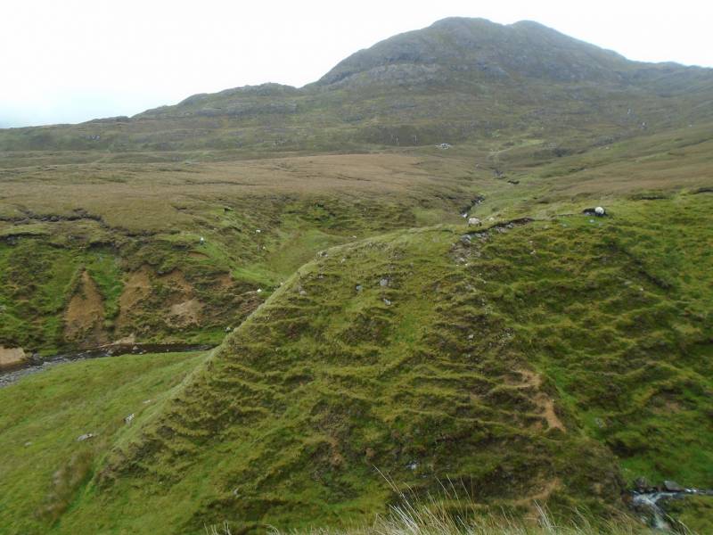 COMMENTSNo comments uploaded yet.
NOTE: ALL information such as Ascent, Length and Creator time taken etc should be regarded as approximate. The creator's comments are opinions and may not be accurate or still correct.
Your time to complete will depend on your speed plus break time and your mode of transport. For walkers: Naismith's rule, an approximate though often inaccurate estimate, suggests a time of 2h 47m + time stopped for breaks
NOTE: It is up to you to ensure that your route is appropriate for you and your party to follow bearing in mind all factors such as safety, weather conditions, experience and access permission.
* Note: A GPS Height in the elevation profile is sourced from the device that recorded the track. An "SRTM" height is derived from a model of elevations for parts of the earth. More detail


MountainViews.ie, a Hill-walking Website for the island of Ireland. 2400 Summiteers, 1480 Contributors, maintainer of lists: Arderins, Vandeleur-Lynams, Highest Hundred, County Highpoints etc

 Lauranna
 Lauranna
 Leatra
 Fergalh
 billbaggins
 Fergalh
 Fergalh
 Fergalh
 simon3
 Visit our Facebook page.