This website uses cookies, which are small text files that the website puts on your device to facilitate operation. Cookies help us provide a better service to you. They are used to track general user traffic information and to help the website function properly.
Feature count in area: 9, all in Waterford,
OSI/LPS Maps: 74, 75, 76, 81, 82, EW-C, EW-K
Highest Place: Knockavelish Hill 124m
Starting Places (1) in area Waterford Coastal Hill: Carrickavrantry Lake West
Summits & other features in area Waterford Coastal Hill: Ardoginna Hill 64m, Coolum Hill 62m, Coxtown Hill 70m, Kilfarrasy Hill 72m, Knockavelish Hill 124m, Knockparson Hill 85m, Monatray Hill 78m, Tinnabinna 102m, Westtown Hill 70m
Note: this list of places may include island features such as summits, but not
islands as such.
Ardoginna Hill, 64mCoastal Hill
Place Rating ..
, Waterford County in Munster province, in no lists Grid Reference X17598 77042,
OS 1:50k mapsheet 82 Place visited by: 8members, recently by: chelman7, Glanman2, Fergalh, leader1, Pepe, hivisibility, sandman, omurchu
I visited this place: NO (You need to be a logged-in member for this.)
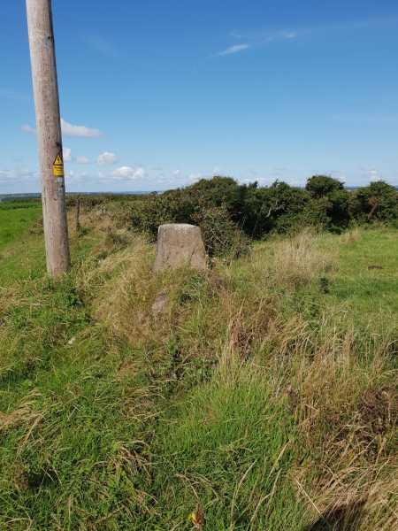
There is now a house in that field and a cleared area right beside the trig pillar. However, as the trig pillar is in the hedgerow between the two fields it can be approached through the field to the north avoiding the cattle. Gate to this field is located at A (X17684 77195)Linkback: mountainviews.ie/summit/5094/comment/23740/
Read Less
Read More
Picture: Summit Trig.
Coastal Hill
by sandman
26 Aug 2018
It is always nice to find a trig at the summit that is not shown on the map well at least the one i am using. Access via the field entrance located at B (X17668 76985) and you can see the trig a few meters over beside an ESB pole.Reasonable views along the coast to Ardmore. Linkback: mountainviews.ie/summit/5094/comment/20031/
Use of MountainViews is governed by conditions and a privacy policy.
Read general information about the site. Opinions in material here are not necessarily endorsed by MountainViews.
Hillwalking is a risk sport. Information in comments, walks, shared GPS tracks or about starting places may
not be accurate for example as regards safety or access permission. You are responsible for your safety and your permission to walk.
See the credits and list definitions.


 Add a Place Comment for Ardoginna Hill


 Our Facebook page.