This website uses cookies, which are small text files that the website puts on your device to facilitate operation. Cookies help us provide a better service to you. They are used to track general user traffic information and to help the website function properly.
Feature count in area: 18, by county: Dublin: 16, Wicklow: 7, Kildare: 1, of which 6 are in both Dublin and Wicklow,
OSI/LPS Maps: 43, 50, 56, AWW, EW-DM, EW-WE, EW-WW
Highest Place: Kippure 757m
Starting Places (77) in area Dublin: Allagour Road, Ballinascorney Golf Club, Ballylerane, Ballylow Bridge, Ballyreagh Wood, Ballyross Forest, Ballysmuttan Long Stone, Barnaslingan Wood, Bohernabreena North CP, Boranaraltry Bridge, Bray Harbour, Cabinteely House, Cannon's Corner, Carrickgollgan, Castelkelly Bridge, Clonkeen Road South, Cloon Wood Cp, Cransillagh Brook , Crone Wood CP, Cruagh Forest Recreation Area, Cruagh Road Hairpin, Curtlestown Wood CP, Dunnes Bank, Enniskerry, Fernhill Estate, Gap Road, Garadhu Road, Glencree Reconciliation, Hell Fire Wood CP, Johnnie Fox Pub, Kilbride Army Camp Entrance, Kilgobbin Lane, Killakee Car Park, Killiney Hill Carpark, Kilmashoge Forest CP, Kilsaran Quarry, Kippure Bridge, Kippure Estate, Kippure Transmitter Gate, Knockbrack, Knockree west, Lackan Wood S, Lamb Doyles, Laughanstown Luas, Lee's Lane, Liffey Bridge, Liffey Head Bridge, Lough Bray Lower, Lough Bray Upper, Lynch's Park Road, Marley Park CP, Novara Avenue, Bray, Old Wicklow Way entrance, Pavilion Theatre, Pine Forest Road, Putland Road, Raheenoon, Rathmichael RC Church, Rathmichael Wood CP, Sally Gap, Sally Gap N, Seahan 265', Seahan 300', Sean Walsh Park, Seefin Trailhead, Shankill Byrnes Bar, Shankill Tributary Bridge, Slademore Road, Sraghoe Brook, St Catherine's Park, The Lamb Hill, The Scalp, Tibradden Forest Recreation Area, Tibradden Lane, Ticknock Forest, Vance's Lane, Wyattville Close
Summits & other features in area Dublin: N: Howth: Ben of Howth 171m N: Naul: Knockbrack 176m S: Dublin South East: Carrickgollogan 275.2m, Glendoo Mountain 585.1m, Killiney Hill 153.5m, Knocknagun 555.3m, Montpelier Hill 383m, Prince William's Seat 553.5m, Tibradden Mountain 466.2m, Two Rock Mountain 536m S: Kippure & Kilbride: Corrig Mountain 617.1m, Kippure 757m, Seahan 647.3m, Seefin 620.6m, Seefingan 722.9m S: Saggart: Cupidstown Hill 378.6m, Knockannavea 400.8m, Saggart Hill 396.9m
Note: this list of places may include island features such as summits, but not
islands as such.
Seefingan, 722.9mMountain Suí Fingain A name in Irish,
Place Rating ..
(Ir. Suí Fingain [OSNB*], 'Fingan's seat'), Suí Fionnagáin, Shankill Mountain, Dublin/ Wicklow County in Leinster province, in Arderin, Vandeleur-Lynam, Irish Highest Hundred Lists, Seefingan is the second highest mountain in the Dublin area and the 96th highest in Ireland. Seefingan is the second highest point in county Dublin.
Grid Reference O08667 16980,
OS 1:50k mapsheet 56 Place visited by: 701members, recently by: rhw, Courin, KateLeckie, MeabhTiernan, knightsonhikes, Deirdreb, taramatthews, davidrenshaw, Prem, Magic, Carolineswalsh, Nailer1967, ElaineM76, MarionP, Tommer504
I visited this place: NO (You need to be a logged-in member for this.)
Longitude: -6.374931, Latitude: 53.192444, Easting: 308668, Northing: 216981,
Prominence: 101.4m, Isolation: 1.5km ITM: 708593 717010 Bedrock type: Fine-grained granodiorite to granite, (Type 1 granodiorite) Notes on name: Seefingan, like Seefin and Seahan, has a large megalithic cairn on its summit.
Short or GPS IDs, 6 char: Sfngn, 10 char: Seefingan Linkback: https://mountainviews.ie/summit/92/
Gallery for Seefingan (Suí Fingain) and surrounds
Summary
for Seefingan (Suí Fingain):
Boggy cairned summit at crossroads of a few routes in NW Wicklow
Summary created by markmjcampion, simon3
2023-05-03 20:58:06
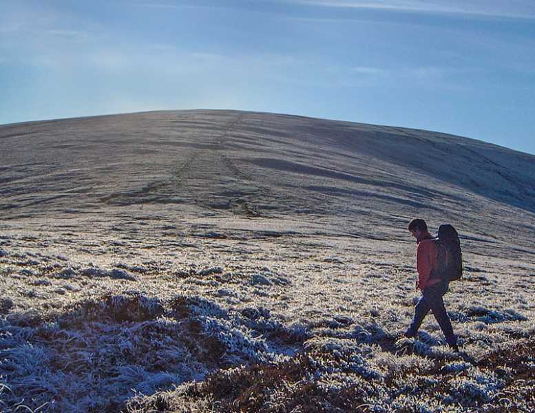
Picture: Seefingan from the north ridge.
Seefingan sits at the meeting of three boggy ridges: Corrig to the N, Seefin to SW and Kippure to the E. The route to Kippure can be particularly boggy after rain. Around 400m W of the summit is an impressive collapsed megalithic tomb. A particular hazard here is that to the NW of the summit is Kilbride Camp with an actively used rifle range. Shown on the OS 1:50k, OSM maps (but not the OSI 1:10k, as on MV) this should be avoided. Great views of the Blessington Lakes, the other hills of the West Wicklow range, south to Mullaghcleevaun and E to Kippure and Sugarloaf.
The going in these hills can be v soft after prolonged rain.
W. Usually Seefingan would be reached at part of a longer walk eg. starting from Seefin Tr (O06299 16818), going over Seefin to Seefingan and possibly further. Allow 90 mins to top.
NW. Start at SHan300 (O07338 20095) and head for Seahan and Corrig before heading S to Seefingan. ! hr 45mins+ depending on conditions underfoot. Finish by heading for Seefin and then WNW down to the road followed by a 2k roadwalk.
S. Park at the gates of the Kippure Estate and follow the track across the road. This eventually leads into heavy forest with a lot of deeply rutted tracks and felled trees. The best option is to head to the river bank (Athdown Brook) and climb up along the left side bank of it. 1.5 hrs
SW. Follow forest tracks to Seefin from A (O06819 14480) and head NE to Seefingan from here. 2 hrs
Notable tracks – the circular track/2846, track/2493 and track/2924
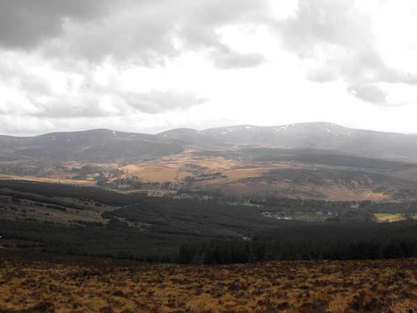
Picture: Towards Mullaghcleevaun Ridge from Seefingan.
Homerclesse on Seefingan
by Homerclesse
28 Mar 2010
I encorporated Seefingan as a Circular route of Seefin, Seefingan, Kippure and the Coronation Plantation.
There a couple of approaches. My favourite is to park at the gates of the Kippure Estate and follow the track across the road. This eventually leads into heavy forest with a lot of deeply rutted tracks and felled trees. The best option is to head to the river bank (Athdown Brook) and climb up along the left side bank of it. A nice view behind you to the Coronation Plantation and the Mullaghcleevaun Range. Once you clear the line of trees on the left then it's simply a matter of heading a little north of west to the summit Seefin. Alternatively, head straight up the side of the summit till you reach Seefingan marked by a very interesting Cairn. Great views of the Blessington Lakes, the other hills of the West Wicklow range, south to Mullaghcleevaun and east to Kippure and Sugar Loaf. If you want it's possible to head to Kippure easily visible to the east with it's huge aerial and then head roughly 220 degrees back down following the Sraghoe Brook, to the Sally Gap and back to the car.
An alternative route is to park on the west side of Seefin at the gates and go straight up the Forest track. Although it will be a up and down walk to your car this way. Linkback: mountainviews.ie/summit/92/comment/4546/
Read Less
Read More
simon3 on Seefingan
by simon3
23 Dec 2002
This icy view appeared en-route from Seefingan to Seefin one cold December day. The hill to the right of the first post is Sorrell Hill. Starting on the skyline to the right of Sorrell there is Slievecorragh (418m - beside Hollywood), below that is Lugnagun (446m) a spur of Sorrell. The rising ground to the right of the picture is Seefin. Linkback: mountainviews.ie/summit/92/comment/249/
Read Less
Read More
csd on Seefingan
by csd
6 Jul 2003
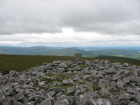
Seefingan in summer. Picture shows the summit cairn and trig pillar, with Sorrell Hill in the background. The route up from Athdown brook was made almost unbearable by the flies - the price we pay for nice summer weather I suppose! Linkback: mountainviews.ie/summit/92/comment/578/
Read Less
Read More
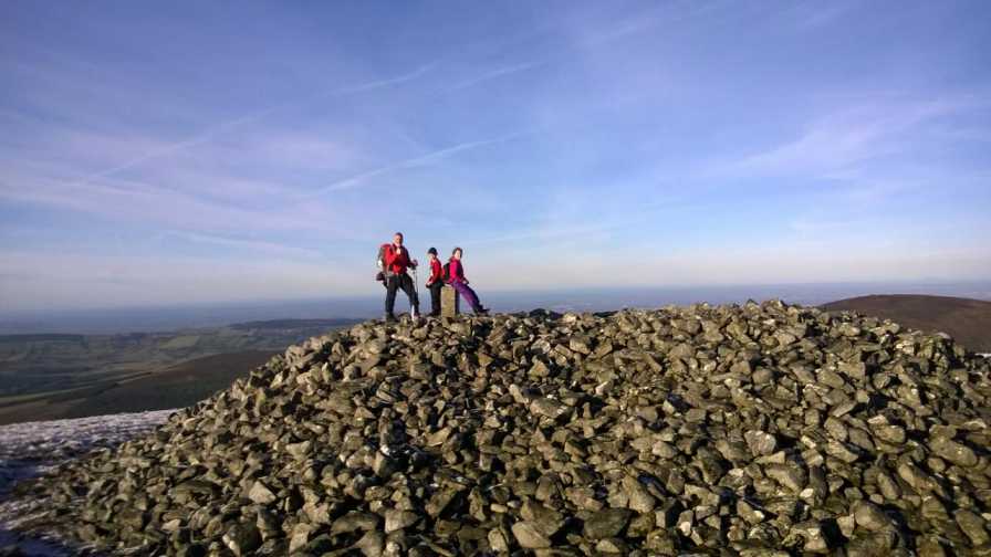
Picture: Pillar atop the cairn on Seefingan
paulocon on Seefingan
by paulocon
16 Dec 2009
A pretty handy walk across from Seefin with only a small amount of boggy land to be encountered on the lowest point between the two hills. The cairn is a similar size to that on Seefin and while it doesn't contain a passage, an indentation to the East hints that perhaps it did at some stage. The cairn is actually positioned away from the summit proper and it would appear this was done to make it visible from around the valley. The summit proper is a short trot across some very boggy land to the east and is marked by a triangular Military Range sign. Linkback: mountainviews.ie/summit/92/comment/4295/
Read Less
Read More
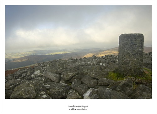
Picture: atop the cairn on Seefingan
Hilltop 2 on Kilbride range loop
by markod
30 Dec 2014
As part of the looped walk (Kilbride military range) this was the second top, the walk across benefitted from the hard frosts of the previous nights.. This could be quite boggy in places(descending from Seefin) although on the accent to the top it's not too bad. Another fine cairn of circa 5000 years ago.... Linkback: mountainviews.ie/summit/92/comment/17779/
Use of MountainViews is governed by conditions and a privacy policy.
Read general information about the site. Opinions in material here are not necessarily endorsed by MountainViews.
Hillwalking is a risk sport. Information in comments, walks, shared GPS tracks or about starting places may
not be accurate for example as regards safety or access permission. You are responsible for your safety and your permission to walk.
See the credits and list definitions.


 Our Facebook page.