This website uses cookies, which are small text files that the website puts on your device to facilitate operation. Cookies help us provide a better service to you. They are used to track general user traffic information and to help the website function properly.
Bluestack MountainsArea, SW: Eany Beg Hills
Subarea
Feature count in area: 45, all in Donegal,
OSI/LPS Maps: 11, 6
Highest Place: Croaghgorm 674m
Starting Places (22) in area Bluestack Mountains: An Leathchruach, Barnsmore Gap, Bensons Hill, Caldragh CP, Clogher South peak, Cruach Mhín an Neanta, Doobin, Eanybeg Water Bridge, Edergole Farm, Gaugin Mountain, Glennacree CP, Hillhead, Lough Finn West, Lough Magrath Beg NE, Lough Muck North, Meenaguse Lough, Sand Lough Forest Picnic Area, Scoil Náisúnta an Choimín, Sheskinlubanagh, Sruell Gap Farm, Sruell River Road, St Columbkilles Well and Altar
Summits & other features in area Bluestack Mountains: Cen: Reelan Hills: Altnapaste 364m, Gaugin Mountain 565m, Lacroagh 403m, Boultypatrick 429m, Croveenananta 476m, Croaghubbrid 416m, Croaghugagh 410m N: Fintown Hills: Aghla Mountain South Top 589m, Aghla Mountain 593m, Scraigs 426m, Croaghleheen 385m NW: Glenties: Cloghercor South 301m, Derkbeg Hill 332m, Drumnalough Hill 282m S: Belshade: Croaghgorm 674m, Croaghgorm South-West Top 597m, Croaghgorm East Top 594m, Ardnageer 642m, Ardnageer SW Top 626m, Banagher Hill 392m, Croaghbane 641m, Croaghgorm Far South-West Top 561m, Cronamuck 444m, Croaghbarnes 498.8m, Glascarns Hill 578.3m, Meenanea 435m SE: Barnesmore: Brown's Hill 496.4m, Cloghervaddy 402m, Croaghagranagh 440m, Croaghanirwore 546.1m, Croaghbrack 401m, Croaghconnellagh 523m, Croaghnageer 569.1m, Croaghnageer East Top 543.5m, Croaghnageer North-East Top 521m, Croaghonagh 451m SW: Eany Beg Hills: Binbane 453m, Binbane NE Top 439m, Lavagh Beg 650m, Lavagh More 671m, Binnasruell 505m, Carnaween 521m, Cloghmeen Hill 429m, Silver Hill 600m, Cullaghacro 476m
Note: this list of places may include island features such as summits, but not
islands as such.
Binbane, 453mHill An Bhinn Bhán A name in Irish,
Place Rating ..
Ir. An Bhinn Bhán [SÓD#], 'white peak'), Donegal County in Ulster province, in Carn Lists, An Bhinn Bhán is the 724th highest place in Ireland. An Bhinn Bhán is the second most westerly summit in the Bluestack Mountains area.
Grid Reference G83838 86968,
OS 1:50k mapsheet 11 Place visited by: 29members, recently by: Colin Murphy, BleckCra, gdg, leader1, eamonoc, IainT, madfrankie, melohara, johncromie, Aidy, hgboyle, markmjcampion, simoburn, chalky, Fergalh
I visited this place: NO (You need to be a logged-in member for this.)
Longitude: -8.251662, Latitude: 54.730438, Easting: 183838, Northing: 386968,
Prominence: 138m, Isolation: 0.7km ITM: 583790 886960 Bedrock type: Quartz & feldspar pebbles, green matrix, (Lough Mourne Formation) Notes on name: According to OG this name is derived from Benn Bogaine or Benn Baghaine, 'peak of the Cenél Bogaine'.
Short or GPS IDs, 6 char: Bnb453, 10 char: Binbane Linkback: https://mountainviews.ie/summit/610/
Gallery for Binbane (An Bhinn Bhán) and surrounds
Summary
for Binbane (An Bhinn Bhán):
Steepish approach to relatively easy Carn.
Summary created by Colin Murphy
2024-04-29 11:18:25
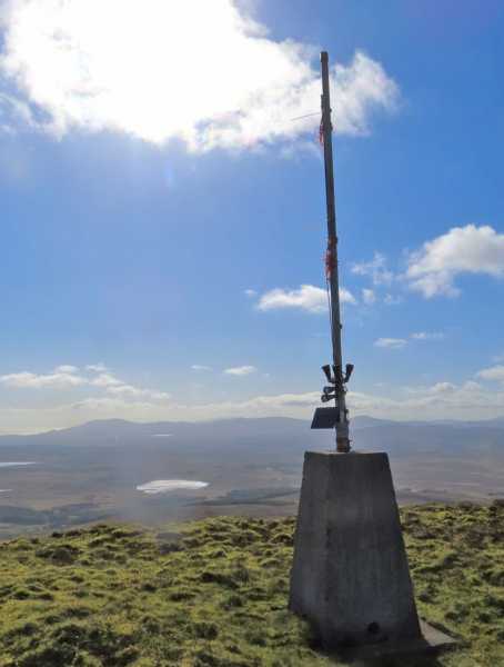
Picture: Summit trig
Binbane and Binbane NE can be reach relatively easily from a forest entrance just off the Bluestack Way. Take the minor road north just off the R262 and follow it until you reach a gate, which you can drive through (closing gate behind you.) 50m further on there is parking for multiple cars at a forest entrance at A (G84475 86189). Take the forest track to the NW, which meanders up through the wood for about 500m (boggy in places) and disappears at the edge of the woods, where you will see a fence and the open hillside. Cross this and proceed NNW up the grassy slope, the gradient becoming increasingly steep. Around B (G84077 86923) swing to a more westerly direction across tussocky grass, to reach the fairly will defined summit, topped by a trig with a metal pole in it. About 1.25 hours to summit.
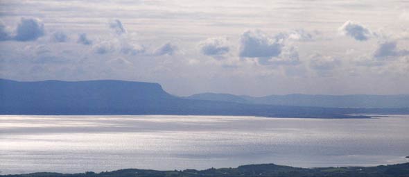
Picture: The distinctive shape of Benbulbin over Donegal Bay
simon3 on Binbane
by simon3
4 Oct 2007
Binbane isn't very high and it doesn't have steep cliffs or other drama. But it does have location so it's not surprising that it has a trig pillar on it because there are clear lines to much of the high ground of Donegal and north Mayo.
Apart from Benbulbin (43k away) as shown in the picture, it's possible to see Slievetooey, Slieve League, Knockalongy in the Ox Mtns and just discernible in the Rayleigh scattering, Nephin 108k away. (not in this pic)
Neither a height based list nor a relative height list would tell you of the attractions of this small summit which is so rewarding on a good day. Often low hills have there own charm. Linkback: mountainviews.ie/summit/610/comment/2850/
Read Less
Read More
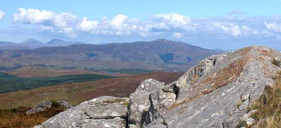
Picture: From Binbane towards the north.
simon3 on Binbane
by simon3
4 Oct 2007
If you approach Binbane from the Glenties - Mountcharles road the summit rises impressively from the bog. You may notice an odd thing. The southern side of the summit is steeper than the northern. This is extremely unusual in Ireland. David Kirk, occasional geological commentator in MV, tells me that the summit is made of "Gaugin" Quartzite but there is a fault so that the southern slopes are a gritstone. There was a major ice cap during the last iceage and this may have caused plucking to steepen the southern slope as well as the gritstone not being as strong as quartzite.
Apparently the Bluestacks are ".. a geological nightmare - with about 10 different rock types of different ages chopped up and re-arranged by a bewildering pattern of faults "
Our picture shows some of the quartzite part of the summit and looks towards another quartzite lump, Errigal (the whitish triangular peak on the left skyline). Going further right the next peak is Slieve Snaght and the much nearer slowly rising peak is Aghla Mountain.
Other views north included two of the main summits of the Inishowen Peninsula including the other Slieve Snaght and Raghtin More at 77.5k away (not in this pic)
One way up is approach it from the road to the north. There's space for 1 or 2 cars at around C (G8408 8893). Much of the way up is boggy underfoot. Linkback: mountainviews.ie/summit/610/comment/2849/
Read Less
Read More
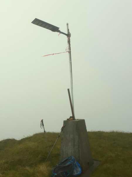
Picture: Solar power on Binbane
I saw the Light
by eamonoc
19 Jul 2022
Done as part of a Carn bagging exercise on a very wet day, visiting Cloghmeen first and then Binbane NE top
finishing on Binbane, at it`s Trig with Street light attached, I have seen fallen Trigs, tilted Trigs, sunken Trigs and one with a seat around it but never one with what appears to be a street light attached ! Linkback: mountainviews.ie/summit/610/comment/23590/
Read Less
Read More
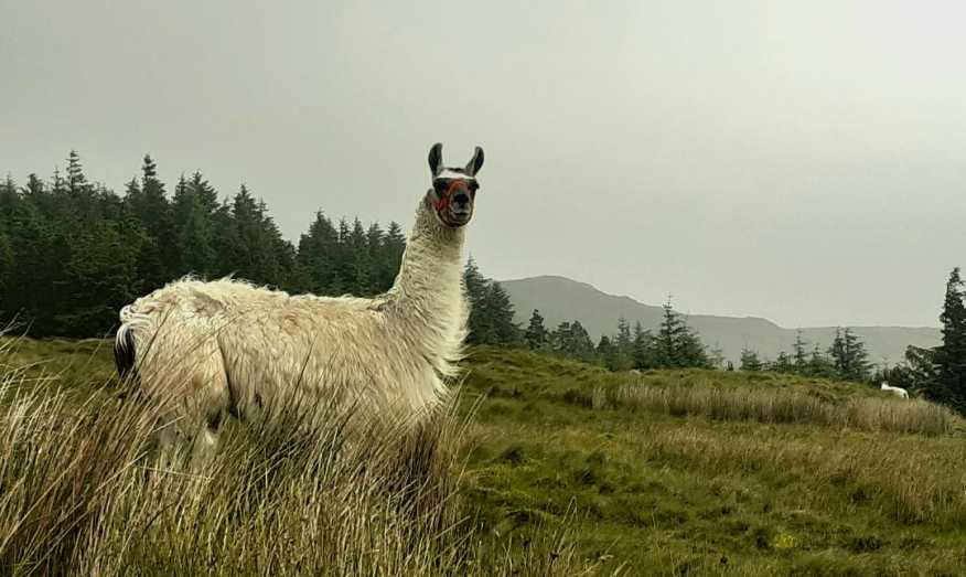
Picture: A big sheep?
You`ll never know what you will find in the Bluestack Mountains
Binbane/Binn Bhan gives terrific views for not a great deal of effort, ideal if you only have a couple of hours spare. From the Frosses to Glenties road a driveable boreen leads up from D (G840 849) towards the hill. A car can be squeezed in by a gate at E (G843 859) (take care not to block access) or there is more space up the gravel road at the entrance to the forest. From the gate a track leads to a ruined farmhouse and above this a gate and stile lead to the open hill. Steep but not too rough ground leads up alongside a fence to the summit. As it's the last summit in the range the view is extensive, stretching from Errigal to North Mayo. Either return the same way or cross rough pathless ground to the East Summit, with a nice little arete to scramble up if that's your thing. The peaty lump SE of the cairn is the true summit. More pathless ground leads down to the NE corner of the wood (the fence is most easily crossed right next to the wood), then down past a ruined cottage with two trees growing in its roof to join the Bluestacks Way at a surfaced track. Turn right to return to the car. 4km, 300m ascent. Linkback: mountainviews.ie/summit/610/comment/20075/
Use of MountainViews is governed by conditions and a privacy policy.
Read general information about the site. Opinions in material here are not necessarily endorsed by MountainViews.
Hillwalking is a risk sport. Information in comments, walks, shared GPS tracks or about starting places may
not be accurate for example as regards safety or access permission. You are responsible for your safety and your permission to walk.
See the credits and list definitions.


 Our Facebook page.