Cookies.
This website uses cookies, which are small text files that the website puts on your device to facilitate operation. Cookies help us provide a better service to you. They are used to track general user traffic information and to help the website function properly.
Features
Nearby features appear when you click the map.
Declutter tracks on map.
Place Search
Video
X
Pub: by
Dartry Mountains Area , NW: Benbulbin Subarea
Feature count in area: 31, by county: Leitrim: 22, Sligo: 10, of which 1 is in both Sligo and Leitrim, OSI/LPS Maps: 16, 17, 25, 26
Highest Place: Truskmore 647m

Starting Places (22) in area Dartry Mountains:
Aghavoghil Middle, Arroo Trail CP, Ballaghnatrillick, Ballintrillick Forest, Barrs East, Castletown, Crumpaun, Curraghan Road, Dough Mountain NW, Dough Mountain West, Drumcliff River Road, Eagles Rock, Edenbaun, Glencar Waterfall, Gleniff Horseshoe Road, Lough Cloonaquin North, Luke's Bridge, Mountain Wood, Poulveha River, Thur East, Tormore Car Park, Truskmore Transmitter Entrance

Summits & other features in area Dartry Mountains:
N: Truskmore: Gortnagarn 445m, Tievebaun 611m, Truskmore 647m, Truskmore SE Cairn 631m
NE: Arroo Keeloges: Aganny Top 482m, Aghalateeve 432m, Agow Top 423m, Arroo Mountain 523m, Conwal North 421m, Crocknagapple 372m, Keeloges 452m
NW: Benbulbin: Annacoona Top 597m, Benbulbin 526m, Benwiskin 514m, Benwiskin South Top 508m, Kings Mountain 462m
SE: Manorhamilton Hills: Ballaghnabehy Top 413m, Benbo 415m, Dough Mountain 462m, Lackagh Mountain 449m, Larkfield 305m, Naweeloge Top 441m, Thur Mountain 442m
SW: Castlegal Hills: Copes Mountain 452m, Crockauns 463m, Hangmans Hill 400m, Keelogyboy Mountain 438m, Keelogyboy Mountain Far East Top 418m, Keelogyboy Mountain NE Top 435m, Keelogyboy Mountain SW Top 417m, Leean Mountain 417m

Note: this list of places may include island features such as summits, but not islands as such.
Rating graphic.
Benbulbin, 526m Mountain Binn Ghulbain A name in Irish,
Place Rating ..
(Ir. Binn Ghulbain [GE], 'Gulban’s peak' or 'jaw-shaped peak') Benbulben an extra name in English, Sligo County in Connacht province, in Arderin Lists, Benbulbin is the 488th highest place in Ireland. Benbulbin is the most westerly summit in the Dartry Mountains area.
Grid Reference G69226 46352, OS 1:50k mapsheet 16
Place visited by: 406 members, recently by: chelman7, ToughSoles, Overarroo, knightsonhikes, Carolineswalsh, konrad, SeanPurcell, FoxyxxxLoxy, Krzysztof_K, Moirabourke, JohnHoare, johncusack, a3642278, rquirke27, ppschweppe
I visited this place: NO (You need to be a logged-in member for this.)
Longitude: -8.474211, Latitude: 54.364892, Easting: 169226, Northing: 346352, Prominence: 61m,  Isolation: 1.2km, Has trig pillar
ITM: 569181 846352
Bedrock type: Dark fine-grained cherty limestone, (Dartry Limestone Formation)
Notes on name: Benbulbin, with its limestone escarpment resembling the prow of a ship, is one of the most recognisable Irish mountains. It is also steeped in legend. It takes its name from Conall Gulban, son of Niall of the Nine hostages, who was fostered here. Fionn Mac Cumhaill finds his son Oisín naked under a rowan tree on Benbulben, having not seen him for seven years. It is also the spot where Diarmuid Ó Duibhne is finally killed by a boar, after he and Gráinne have been pursued for many years throughout Ireland by Fionn. Sometimes spelt Benbulben.
  Short or GPS IDs, 6 char: Bnblbn, 10 char: Benbulbin

Linkback: https://mountainviews.ie/summit/402/
Gallery for Benbulbin (Binn Ghulbain) and surrounds
Summary for Benbulbin (Binn Ghulbain): Remarkable mountain, watch out for access.
Summary created by Peter Walker, simon3, wicklore 2019-03-18 08:03:43
            MountainViews.ie picture about Benbulbin (<em>Binn Ghulbain</em>)
Picture: White giant above the plain
There have been access difficulties regarding this summit.
A simple approach to Benbulbin is to start at A (G684 451) however some have found difficulties here. A track leads to fields below a steep, but not dangerous, climb up to the top of the Benbulbin - Kings Mountain ridge. Keep to the right of a small river gully on the ascent as this is where the track is. Near the top turn left to head west across the bog for a few hundred metres to the summit trig pillar. Beware of the sharp cliff drops which are so prominent to this hill.

Another route up starts from the north side near Luke's Bridge Luke Br (G6983 4728). You may encounter barbed wire strung across the road before you reach this point. According to MI May 2015, "Despite what it may appear like, that fence is to keep sheep in, not to keep walkers out and the parking area a couple of hundred metres beyond the fence is currently the main access point for ascending Benbulbin." (It should be noted that vehicle break-ins are far from an unusual occurrence here).

Fantastic views are to be had of the nearer Dartrys, as well as across to Slieve League in Donegal.
Linkback: mountainviews.ie/summit/402/comment/5161/
Member Comments for Benbulbin (Binn Ghulbain)
Comment create / edit display placeholder

Access Problems, Wednesday 17 August 2011
by Wildcat 19 May 2015
The corrected route still starts at grid reference A (G684 451). Note that parking is difficult and junctions, lanes and farm entrances must be left clear so tractors and trailers can get access. There is really only space for one car close to this point. From here, follow the surfaced road about 20m to the north-east (direction Benbulbin Farm). The Benbulbin Farm road then turns right (south-east) - from the bend in the surfaced road, continue straight on (north-east) on an unsurfaced track (a lane between trees) as far as a gate. Go through the gate then continue on this lane for about 300m north-east to the point where it bends to the right (east) - there's a gate on the left (grid reference B (G685 453)) which leads to the rough grazing north of the lane without any problems. (Please note, the lane dead ends 400m to the east at a gate bristling with metalwork, barbed wire and a 'no trespassing' sign.) From the gate at B (G685 453), head gradually uphill keeping to the right, gradually getting further north of the lane and steadily closer to the LEFT bank of the small river gully mentioned in the summary. Ascend steep grassy slopes east of some trees but north-west of the gully and find a path that zig-zags through a narrow rock band to reach the reedy slopes above. Continue uphill and somewhat to the left, across boggy grassland, to reach the summit trig pillar. Linkback: mountainviews.ie/summit/402/comment/6485/
Read Less
Read More

            MountainViews.ie picture about Benbulbin (<em>Binn Ghulbain</em>)
Picture: Trig Point
Geo on Benbulbin
by Geo 31 May 2009
Climbed on Tuesday 26th May 09. Followed emchugh's route from the water works road, without any difficulty and thanks to him for his excellent directions. At the end of the roadway, where it peters out before crossing the bog, the temptation is to make straight for the gully taking the stream down off the mountain ahead. From experience it might be better to aim slightly left as you cross the bog and follow the sheep farmer's Quad tracks if you want to keep your feet dry! Anyway, the bog is only a few minutes long and before you know it you'll be climbing up along the river and unable to tear your eyes form the view behind, which only gets better as you climb. If its a good day like we had, you'll kick yourself if you don't have a camera. The views of the cliffs, the sea, the South Donegal coast, all magnificent. When up on the plateau, we turned right and followed our noses up and over the little hill, then along a grassy pasture and further onto the trig point of Benbulbin, a trig point partially obscured by peat hags and not easy to see in mist I'll bet. From here we ventured further out to the "nose" of the massif at Theebaun as it's called on the 1:50,000 OSI at C (G68304 46215). The panorama here will not disappoint, I can assure you of that, unless you have had your emotions surgically removed! We had lunch on a cliff edge rock and then returned to the trig point, where we decided to go on to King's Mountain. Linkback: mountainviews.ie/summit/402/comment/3787/
Read Less
Read More

            MountainViews.ie picture about Benbulbin (<em>Binn Ghulbain</em>)
Picture: Eastern slope of Benbulbin
eflanaga on Benbulbin
by eflanaga 15 Mar 2006
Benbulbin (Climbed Sunday 13th) Started walk at A (G684 451) for the relatively short (1.6K) but rather steep ascent (450m) to the summit cairn. Track at start of walk runs for about 400m up and around to a metal gate. Once through gate simply follow the gulley to your left onwards and upwards to the top. The forecast had suggested that the mist would linger on the west coast and high ground for a good part of the day and it wasn’t wrong. While, there would be clear spells on some of the hills around lunchtime the mist steadfastly refused to vacate Benbulbin until much later in the evening. As it was, by the time I had climbed about 100m visibility had dropped to around 30 metres. Four young lads on scramblers across the gulley, one of whom appeared to be intent on trying to ride his bike up the sheer incline to the top, quickly disappeared from view, the irritating ‘phut phut phut’ of their engines taking somewhat longer to fade into the distance. I found it somewhat easier to climb alongside the gulley rather than climbing up through it . It’s only a short walk from the top of the gulley to the Trig point on the summit. Due to the mist there was little to see except for the inscribed metal plate on the Trig dedicated to a young man called Kevin Myers who apparently passed away at age of twenty-eight in 2002. Not sure if his unfortunate passing had anything to do with the mountain. After picking up a couple of discarded beer tins near the Trig it was time to check bearings and start the long trudge across to my next target, Benwiskin. The trek, described by Sean below, was made much more arduous because of the poor visibility and the prevailing cold, wet and miserable conditions.(See Benwiskin for next stage of walk). Linkback: mountainviews.ie/summit/402/comment/2228/
Read Less
Read More

            MountainViews.ie picture about Benbulbin (<em>Binn Ghulbain</em>)
Picture: Dawn behind Benbulbin.
simon3 on Benbulbin
by simon3 20 Dec 2009
Taken some 20 minutes after dawn, Benbulbin's distinctive shape is set against the dawn of a cold, December day. Linkback: mountainviews.ie/summit/402/comment/4304/
Read Less
Read More

            MountainViews.ie picture about Benbulbin (<em>Binn Ghulbain</em>)
Picture: The fantastical cliffs of Benbulbin
A teenager’s awakening on Benbulbin…
by kernowclimber 6 May 2010
The unimaginable happened this weekend. Curiosity stirred by photos and accounts of our recent walks finally won over my teenage daughter, who announced that she wanted to see what all this hill walking malarkey was about. Praying for sunshine, we chose Benbulbin as a suitable challenge for an unfit, inexperienced teenager, hoping that the limestone topography might inspire her to greater heights in her geography Leaving Cert!

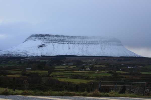
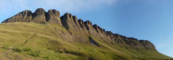
As we approached the towering, deeply scoured walls of the Benbulbin massif from the Mullaghnaneane Crossroads, she announced that they resembled the knuckles of a clenched fist and looked about as welcoming! We parked the car at D (G70300 46791) just across a small concrete bridge then picked our way across a flat boggy area once cut for turf, heading for a waterfall tumbling down from the lowest point of the plateau above. Climbing steeply upwards alongside the waterfall to the incessant trilling of a skylark and amid mutterings such as “I can’t believe you two do this for fun”, clumps of greenery and rocks she would usually trample underfoot suddenly became of infinite interest, a good excuse to pause for breath. We photographed the Opposite-leaved Golden-saxifrage, Hares-tail Cottongrass, Common Dog-violet and excellent examples of crinoid fossils in the limestone.

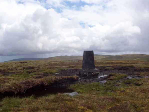
Once on the plateau we headed towards Kings Mountain, a truncated version of Devils Tower in Wyoming, past what she correctly identified as swallow holes, and through a mazy run of eroded peat hags, to race up the slopes to the summit. The views towards Lough Gill, Sligo Town, the Ox Mountains and distant Nephin Begs are enchanting, but she was equally engrossed by our debate about the accuracies of the summit co-ordinates as the GPS and OS map did not seem to agree: parental infallibility, she always knew this was a lie!!

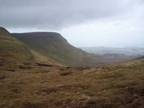
Descending, we struck out across undulating ground towards Benbulbin Head, a promontory of rock that resembles the prow of a great battleship ploughing hard into the oceanic realms of the setting sun. Even my sandwiches, crusts and all, were as delicious as the landscape here in Yeats Country. Poetry flowed spontaneously from lips more accustomed to rap and hip hop…

And so on to the summit of Benbulbin, traversing the tops of cliffs offering stomach churning views down precipitous gullies. OS pillar kissed and summit bagged, we bore SE to descend steep ground at 
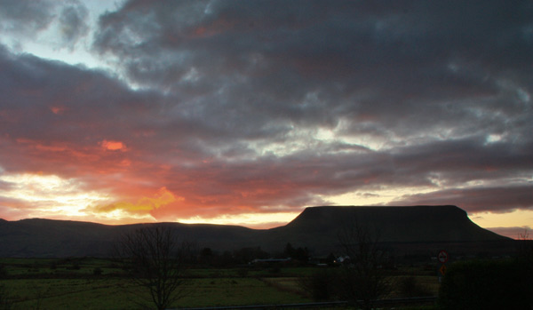
E (G69554 46256) above the Glendarragh Valley. Emboldened by her day’s achievements, my teenage couch potato became a gazelle, bounding over the little terraces created by soil creep to beat me to the bottom where we picked up a rough track leading back to the car. Her beaming smile at my endorsement of her first 10km walk will linger in my mind hopefully as long as her memory of the cliffs of Benbulbin; no longer a clenched fist, but transformed into a giant mammoth’s tooth, fantastical, ancient and mysterious in the fading sun. Linkback: mountainviews.ie/summit/402/comment/4680/
Read Less
Read More
EDIT Point of Interest
text
Videos

Recent Contributions
x
Conditions and Info
Use of MountainViews is governed by conditions and a privacy policy.
Read general information about the site.
Opinions in material here are not necessarily endorsed by MountainViews.
Hillwalking is a risk sport. Information in comments, walks, shared GPS tracks or about starting places may not be accurate for example as regards safety or access permission. You are responsible for your safety and your permission to walk.
See the credits and list definitions.

OSi logo
OSNI/LPS logo
Open Street Map
(Various variations used.)
British summit data courtesy:
Database of British & Irish Hills