Donation Request 2024

DONATE
Members and Supporters, the MountainViews Committee requests your help to meet the costs of the website and of other activities such as insured events or publications.
You do not have to be logged in to donate.
Features
Nearby features appear when you click the map.
Declutter tracks on map.
Place Search
Video
X
Pub: by
South East Midlands Area , W Cen: Slieveardagh Subarea
Feature count in area: 31, by county: Laois: 6, Carlow: 1, Offaly: 1, Kildare: 2, Kilkenny: 13, Tipperary: 8, OSI/LPS Maps: 28A, 28B, 47, 48, 49, 53, 54, 55, 59, 60
Highest Place: Slievenamon 720.2m

Starting Places (16) in area South East Midlands:
Ballinvarry West, Clodiagh Church, Coolnahau, Coppanagh Wood South, Freney's Well, Glynn, Gorlough Wood, Hill of Allen, Inistioge, Killamery Wood East, Kylebeg Wood, Lingaun River, Mount Alto Wood, Mullenbeg Wood South, Newtown Upper School, Slievenamon Walk Head

Summits & other features in area South East Midlands:
E: Barrow: Clogrennan Hill 336m, Newtown Hill 208m
N Cen: Timahoe Hills: Ballaghmore Hill 268m, Cullenagh Mountain 317m, Fossy Mountain 332m, Hewson Hill 261m
N: Croghan: Croghan Hill 234m
N: Newbridge Hills: Dunmurry Hill 233m, Hill of Allen 219m
S: Mullinavat: Coolnahau Hill 265m, Corbally Hill 285m, Mount Alto 276m, Tory Hill 292m
S: Slievenamon: Knockahunna 502.8m, Sheegouna 553.5m, Slievenamon 720.2m, Slievenamon North-West Top 564m
S: Windgap: Carricktriss Gorse 314m, Carrigadoon Hill 296.9m, Faranaree Hill 283m
SE: Brandon Hill: Brandon Hill 515m, Coppanagh 365m, Croghan 365m
W Cen: Durrow: Ballynalacken Hill 314m, Caponellan Hill 253m, Knockmannon Hill 315m
W Cen: Slieveardagh: Clomantagh Hill 349m, Knocknamuck 340m, Monabrogue 284m
W: Horse & Jockey: Kill Hill 241m, Killough 235m

Note: this list of places may include island features such as summits, but not islands as such.
Rating graphic.
Clomantagh Hill, 349m Hill Cnoc na Cloiche Mantaí A name in Irish,
Place Rating ..
(poss. Ir. ‡Cnoc na Cloiche Mantaí [PDT], 'hill of An Chloch
Mhantach or the gapped stone')
Killoshulan an extra name in English, Kilkenny County in Leinster province, in Binnion Lists, Clomantagh Hill is the 1059th highest place in Ireland.
Grid Reference S33268 65496, OS 1:50k mapsheet 60
Place visited by: 35 members, recently by: Moirabourke, Arcticaurora, Colin Murphy, Oscar-mckinney, Jai-mckinney, Carolyn105, benjimann9, chelman7, markwallace, TippHiker, LiamG1951, sarahryanowen, Benbruce, dregish, TommyV
I visited this place: NO (You need to be a logged-in member for this.)
Longitude: -7.508198, Latitude: 52.739893, Easting: 233268, Northing: 165496, Prominence: 217m,  Isolation: 5.6km, Has trig pillar
ITM: 633210 665537
Bedrock type: Cherty, muddy, calcarenitic limestone, (Clogrenan Formation)
Notes on name: The name Clomantagh Hill is given by Eoghan Ó Ceallaigh in Cois Feoire. The word mantach is usually applied to teeth. It means 'gummy' or 'gaptoothed'. It appears to be Brittonic due to the retention of -ant-, as this regularly develops to -éad- in modern Irish. Clomantagh is a parish in the barony of Crannagh. The Irish form of this name is An Chloch Mhantach [logainm.ie].
  Short or GPS IDs, 6 char: ClmnHl, 10 char: ClmntghHil

Linkback: https://mountainviews.ie/summit/902/
Gallery for Clomantagh Hill (Cnoc na Cloiche Mantaí) and surrounds
Summary for Clomantagh Hill (Cnoc na Cloiche Mantaí): A gem in Kilkenny
Summary created by Colin Murphy, wicklore 2023-10-12 18:14:38
            MountainViews.ie picture about Clomantagh Hill (<em>Cnoc na Cloiche Mantaí</em>)
Picture: High point of Clomantagh
Park at A (S33125 66710) and go through the gate to find your way onto the hill. The summit lies about 1.5 kms away across varied terrain. Clomantagh is the third highest hill in Kilkenny, and is quite different from many hills in the South Midlands. It has exposed limestone, and dry stone walls similar to those in the west of Ireland. Windswept trees and ledges of exposed rock add to the beauty of this hill. Single strand electric fencing parallel to most of the dry stone walls should be treated with caution as they could be live. Also in the summer cattle on the hill may try to chase you - if so wave your arms and shout to ward them off.
Linkback: mountainviews.ie/summit/902/comment/5661/
Member Comments for Clomantagh Hill (Cnoc na Cloiche Mantaí)
Comment create / edit display placeholder

            MountainViews.ie picture about Clomantagh Hill (<em>Cnoc na Cloiche Mantaí</em>)
Picture: Windswept and sweeping. Are there cows behind you?
Attack of the cows!
by wicklore 17 Jul 2010
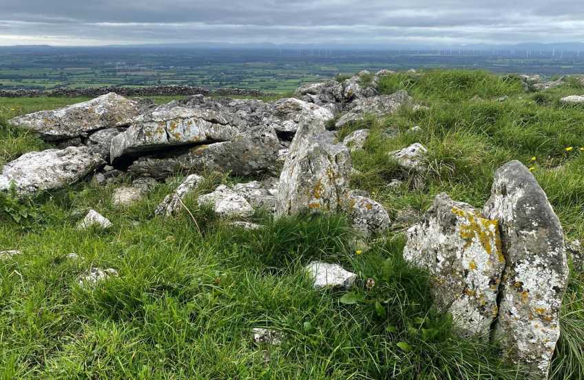
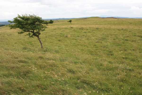
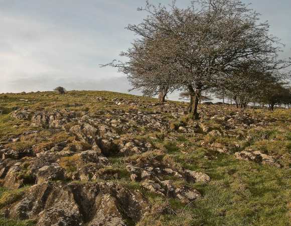
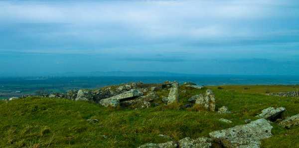
Clomantagh is a pleasant hill. It offers swathes of grassland, windswept trees, old stone walls running hither and tither and excellent views. But be warned – curious potential danger lurks there for the unsuspecting walker!

The starting point referred to by oldsoldier and jackill gives direct access onto the hillside. The summit is about 1.5kms across this rural idyll. Various stone walls are hopped, and the exposed limestone and windswept trees keep the walk interesting. However there was also extensive electric fencing, which seems to run next to most of the walls. A slip while hopping a wall could be shocking! I don’t know if they were live or not, but I wasn’t testing them! Several sections of the walls were collapsing or close to collapse. The reason for the electric fencing is clear –there were many cattle out on the hillside and the fencing prevented them from roaming beyond their allotted space or damaging the walls. This brings me to the second danger. Cattle attack! I had read csd’s experience of aggressive cattle on Mount Oriel last week with great interest. And earlier today I was unceremoniously ejected from the summit of Tory Hill in south Kilkenny in a similar incident. In that instance there was no gate to hop over so I had to hide in the gorse after running away with 5 cows in hot pursuit! Imagine a man sitting in the thorniest of hiding places, listening with fear as he hears the crack of twigs and heavy breathing as his pursuers pass close by. I resolved that one by using the rocky mini cliffs on Tory Hill to make good my escape.

Back to Clomantagh. As I descended I entered an area of about 30 cattle. A re-run of my earlier rout on Tory Hill nearly occurred. They all lumbered over and moved in close. There were no gates or hedges in this area and I was facing fight or flight. wicklore then bravely decided that enough was enough and it was time to stand up for us bipeds. Through crafty techniques and the use of two walking poles I managed to get to a place of safety (over a wall 200 metres away!). While I’m sure they don’t mean deliberate harm, their habit of closing in together and pushing each other forward could result in an unintentional crush. In a curious reflection of a childhood game they insist on running up each time you turn away. This kind of experience is not for the faint hearted! My technique? – lots of waving of arms and shouting at them! (This works for a couple of seconds before they move back in, so keep it up as you move)
Cows notwithstanding, Clomantagh is a lovely hill with a pleasant feeling. The lonely ruined cottage mentioned by jackill and a larger ruin just inside the forest nearby hint at another, possibly pre-famine, time when perhaps this hill was used in a different way. This was a sad thought, but was balanced by my happiness in having completed all of the MountainViews listed hills and mountains in Leinster, as Clomantagh was the last. Linkback: mountainviews.ie/summit/902/comment/5956/
Read Less
Read More

            MountainViews.ie picture about Clomantagh Hill (<em>Cnoc na Cloiche Mantaí</em>)
Picture: Exposed limestone
jackill on Clomantagh Hill
by jackill 17 Jan 2010
Walking towards the summit your eye is drawn to the rough , wind sculpted trees springing up almost by magic from fissures in the limestone. This area is I understand being considered for SAC status by the EU. The National Parks and wildlife service notes
"The hills are of limestone overlain by shales and/or sandstones so the surface geology is variable, with each rock type maintaining a very different type of vegetation. This particular site is mostly limestone, exposed as small ledges or as flat sheets when it is weathered into the
pavement pattern so well known from the Burren" and don't pick the flowers! " The Rare and legally protected (Flora Protection Order, 1987), Green-winged Orchid
(Orchis morio) grows sparingly through this community. Two other orchid species,
Frog Orchid (Coeloglossum viride) and Common Spotted-orchid (Dactylorhiza cf.
fuchsii) are also recorded from the site" Linkback: mountainviews.ie/summit/902/comment/4359/
Read Less
Read More

            MountainViews.ie picture about Clomantagh Hill (<em>Cnoc na Cloiche Mantaí</em>)
Picture: The summit cairn looking towards the Slieve Blooms
jackill on Clomantagh Hill
by jackill 11 Feb 2010
I parked at the co-ordinates provided by oldsoldier (which is a coillte access road despite my initial concerns that it was a farm roadway) and took a quick 15 minute walk hugging the forest edge across a most unusual and unexpected karst landscape. Exposed weathered limestone, rough hillocks, hollows and hump backed, stunted trees leaning south all give this hill its gap-toothed name.Hop the stone wall, built with no mortar, at the roofless house and then follow the wall to the summit. The trig bolt is set in a square of concrete on top of a megalithic tomb. An extract from Lewis Topographical Dictionary, 1837 says the following "On the summit of Clomanto hill is circular mound of stones, 87 paces in circumference, enclosed by a circular barrier of stones, including several acres, approaching nearest to the mound on the east. Part of this circle has been destroyed; the name 'Cloghman-Ta,' signifying in the Irish language the "stone of God," is sufficiently indicative of the use to which this place was applied" A little bit differant then to the MViews name explanation. All together though both explanations suit a special and unusual little hill. Linkback: mountainviews.ie/summit/902/comment/4358/
Read Less
Read More

Re: what is this? - Paddyhillsbagger
by scapania 18 Apr 2010
The flower in the below picture is the wood anemone (Anemone nemorosa). Its mainly a plant of limestone woodland, but also grows on open limestone grassland, as I assume must be the case at the summit of Clomantagh Hill. Its always one of the first flowers out in the spring, and can form dense carpets of white flowers in woods before the leaves of the trees shut out the light. The flower is superficially similar to the Mountain Avens (Dryas octopetala), but has six petals rather than eight. The leaves and growth habit are also different, the wood anemone has deeply dissected leaves on weak, individual stems, while the mountain avens has shallowly lobed, oak-like leaves and forms dense, woody clumps. Mountain avens is very restricted in distribution, being frequent on the limestone pavement of the Burren and found rarely in one or two other places in the country, but isn't found anywhere near Kilkenny, while the Wood Anemone is frequent across the country. Linkback: mountainviews.ie/summit/902/comment/4639/
Read Less
Read More

            MountainViews.ie picture about Clomantagh Hill (<em>Cnoc na Cloiche Mantaí</em>)
Picture: Mountain Avens?
What is this?
by paddyhillsbagger 18 Apr 2010
Actually took the wife up this hill and she enjoyed the glorious views afforded at the top as well as the glorious sunshine on the day! The plants and trees at the top certainly are interesting, but we are stumped as to the name of the flower photographed. We seem to be going for Mountain Avens or Wood Anemone. Can anyone out there identify this flower? Linkback: mountainviews.ie/summit/902/comment/4638/
Read Less
Read More
EDIT Point of Interest
text
Videos
(none available)
Recent Contributions
x
Conditions and Info
Use of MountainViews is governed by conditions and a privacy policy.
Read general information about the site.
Opinions in material here are not necessarily endorsed by MountainViews.
Hillwalking is a risk sport. Information in comments, walks, shared GPS tracks or about starting places may not be accurate for example as regards safety or access permission. You are responsible for your safety and your permission to walk.
See the credits and list definitions.

OSi logo
OSNI/LPS logo
Open Street Map
(Various variations used.)
British summit data courtesy:
Database of British & Irish Hills