Cookies.
This website uses cookies, which are small text files that the website puts on your device to facilitate operation. Cookies help us provide a better service to you. They are used to track general user traffic information and to help the website function properly.
Features
Nearby features appear when you click the map.
Declutter tracks on map.
Place Search
Video
X
Pub: by
Twelve Bens Area , E: Glencorbet Subarea
Feature count in area: 34, all in Galway, OSI/LPS Maps: 37, 44, EW-CON, MSW
Highest Place: Benbaun 729m

Starting Places (48) in area Twelve Bens:
Angler's Return, Barr na nÓran Road, Ben Lettery Hostel, Bogville Road, Bridge St Clifden, Bundorragha Estuary Cross, Bunnageeha, Cannaclossaun, Connemara Mountain Hostel, Connemara National Park Visitor Centre, Dernasliggaun, Doire na bhFlann North, Doughruagh CP, Emlaghdauroe Bridge, Emlaghdauroe South, Fee Lough SW, Foher, Glasbeg Stream, Glashmore Bridge, Glencoaghan River Bridge, Glencraff Road End, Gleninagh River, Illaunroe North, Illaunroe South, Inaghbeg Path, Kylemore Abbey Exit, Kylemore River, Letterfrack Lodge, Lettergesh Beach, Lough Anivan Bend, Lough Auna S, Lough Fee East, Lough Nacarrigeen S, Lough Tanny, Muck Lough NW, Nambrackkeagh Lough, Owen na Baunoge River, Owengar Bridge, Owenglin River, Owenwee River, Pollacappul Lough E, Pollacappul Lough W, Shanvally, Skeaghatimull, Ten Bens Cottage, Tooreennacoona River, Western Way Cnoc na hUilleann, Western Way Inagh Cottages

Summits & other features in area Twelve Bens:
Cen: Lough Auna Hills: Cregg 297m, Townaloughra East Top 216m
Cen: Polladirk: Bencullagh 632m, Maumonght SW Top 454m, Diamond Hill 442m, Knockbrack 442m, Maumonght 602m
E: Glencorbet: Benbaun 729m, Benbrack 582m, Benbaun 477m, Knockpasheemore 412m, Benfree 638m, Muckanaght 654m
N: Doughruagh: Altnagaighera 549m, Benchoona 581m, Benchoona East Top 585m, Currywongaun 273m, Doughruagh 526m, Doughruagh South Top 525m, Garraun 598m, Garraun South Top 556m, Letterettrin 333m
SE: Glencoaghan Loop: Bencollaghduff 696m, Benglenisky 516m, Benlettery 577m, Bencorr 711m, Bencorr North Top 690m, Bencorrbeg 577m, Binn an tSaighdiúra 653m, Benbreen 691m, Benbreen Central Top 680m, Benbreen North Top 674m, Derryclare 677m, Bengower 664m

Note: this list of places may include island features such as summits, but not islands as such.
Rating graphic.
Benbaun, 729m Mountain An Bhinn Bhán A name in Irish,
Place Rating ..
(Ir. An Bhinn Bhán [logainm.ie], 'white peak') County Highpoint of Galway in Connacht province, in County Highpoint, Arderin, Vandeleur-Lynam, Irish Highest Hundred Lists, An Bhinn Bhán is the highest mountain in the Twelve Bens area and the 89th highest in Ireland. An Bhinn Bhán is the highest point in county Galway.
Grid Reference L78558 53903, OS 1:50k mapsheet 37
Place visited by: 637 members, recently by: rhw, purpleknight, discovering_dann, taramatthews, Magic, Prem, Carolineswalsh, JordanF1, MarionP, Hikerjjl, edowling, Tuigamala, Padraigin, Lyner, Moirabourke
I visited this place: NO (You need to be a logged-in member for this.)
Longitude: -9.831791, Latitude: 53.521228, Easting: 78558, Northing: 253903, Prominence: 684m,  Isolation: 0.9km, Has trig pillar
ITM: 478532 753923
Bedrock type: Pale quartzites, grits, graphitic, (Bennabeola Quartzite Formation)
Notes on name: An Bihnn Bhán means 'the white peak' and is the highest mountain in Galway. You could say it is the Mont Blanc of Connemara. There is a lot of white rock here, mainly quartz, though this is more a feature of Benbrack. An odd thing about the Twelve Bens of Connemara is that nobody seems to know exactly which are the twelve peaks in question. There are at least 20 peaks with names in binn in this area. However, the notion of twelve peaks goes back at least to the time of Roderic O'Flaherty, who wrote in 1684 of the twelve high mountaines of Bennabeola, though he did not enumerate them (O'Flaherty, 106). In Irish the question doesn't even arise: there is no number, they are just na Beanna Beola, 'the peaks of Beola'. Beola was a giant and chieftain of the Fir Bolg, whose name also features in the village Tuaim Beola (Toombeola).
  Short or GPS IDs, 6 char: Bnbn, 10 char: Benbaun

Linkback: https://mountainviews.ie/summit/89/
Gallery for Benbaun (An Bhinn Bhán) and surrounds
Summary for Benbaun (An Bhinn Bhán): 12 Bens quartzite highpoint amidst magnificent peaks and valleys
Summary created by markmjcampion, simon3, Colin Murphy 2023-09-11 13:05:28
            MountainViews.ie picture about Benbaun (<em>An Bhinn Bhán</em>)
Picture: Benbaun from Bencollaghduff
Benbaun is the highpoint of the 12 Bens, located 4k SW of the Leenane road. It's a characterful hill esp when viewed from the S but the mixture of steep, grassy and rocky ground means good boots are essential. Take care on the ridges as the steep ground may not be obvious. The views from the top are potentially stunning and widespread, taking in the rest of the Bens, the Maamturks and the south Mayo hills.

N. If parking near Shanvally (L81714 56584) head 1km SW up a grassy, pathless, steep, wet slope to Knockpasheemore. Continue SW for 3km, the terrain becoming v rocky and steep as you near Benbaun.. A 4 to 5 hrs return of 11k with 800m ascent.
You can also park up a minor road to Canclosn (L79598 57348) – as you near the Glencorbet farmhouse look out for a place to cross the river and aim for Knockpasheemore. When descending from Benbaun don't drop into the valley until you're at A (L796 533). This 10.5k route should take 5 hrs.

As an alternative descent, you can drop down to the col at B (L78021 54308) and descend N into Glen Corbet. Indeed Benfree is an easy extra summit and you can descend N from either of its cols. This adds about 30 mins.
Alternatively, head further into the glen to C (L78618 55888) before swinging left for the summit or ridge. 4 hrs+ for this 10k return of 746m ascent.

The 15k Glencorbet horseshoe of 1,300m ascent takes in 5 summits...see track/1454. Allow 7-8 hrs.

Other notable tracks incl track/3928 and track/4341.
Linkback: mountainviews.ie/summit/89/comment/4849/
Member Comments for Benbaun (An Bhinn Bhán)
Comment create / edit display placeholder

            MountainViews.ie picture about Benbaun (<em>An Bhinn Bhán</em>)
Picture: Steep learning curve
The hedgehog awakes
by wicklore 21 Sep 2022
Hedgehogs emerging from hibernation feel unsure of themselves. They feel aches & pains from long unused muscles & joints. They need time to reorient & learn how to navigate through previously familiar territory. Indeed, as one article puts it “Hedgehogs coming out of hibernation are wobbly and confused, and even more likely than usual to stumble into trouble.”

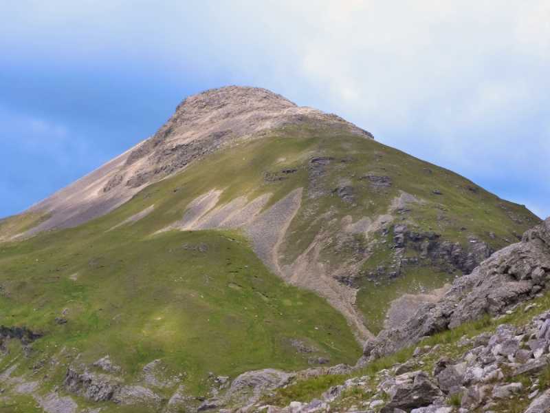
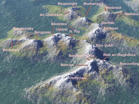
And so it was, on a recent September morning, I emerged from a year-long hibernation. Like a bleary-eyed, freshly-woken hedgehog I gazed about me, overwhelmed & struggling to know how to start. The mountains of the Owenglin valley loomed about me, and I stared agog at the vast bulk of Benbaun. It appeared……big, and……menacing, and……big. And the valley floor before me looked….difficult, and ……wet and, ……difficult. My eyes slowly scanned north & west of Benbaun, taking in Benfree, Muckanaght, Bencullagh & finally Maumonght. This was the route for the day. I trembled before such a sight. My knees wobbled as I espied distant sheep clinging precariously to impossible ledges, below cliffs & rocky crags that had no sympathy for the faint hearted. Impossibly steep slopes led up to impossibly high summits.

There was so much to consider. Were my boots laced and tied correctly? Did I have enough water? Was I wearing enough layers, or did I have too much on? What if it rained? What if my walking poles snapped in half? What if my rucksack blew away or there was an earthquake or a flood or what if....…and so it was that a series of doubts & uncertainties cycled through my mind. Having not had a proper hike in over a year, I had clearly lost the plot completely. “Pull yourself together man” I told myself, “you have hiked all of these summits before. Hiking is something you have done countless times, in all weather and conditions. You are Wicklore, Walker of Hills, Explorer of Places, Finder of Things,”

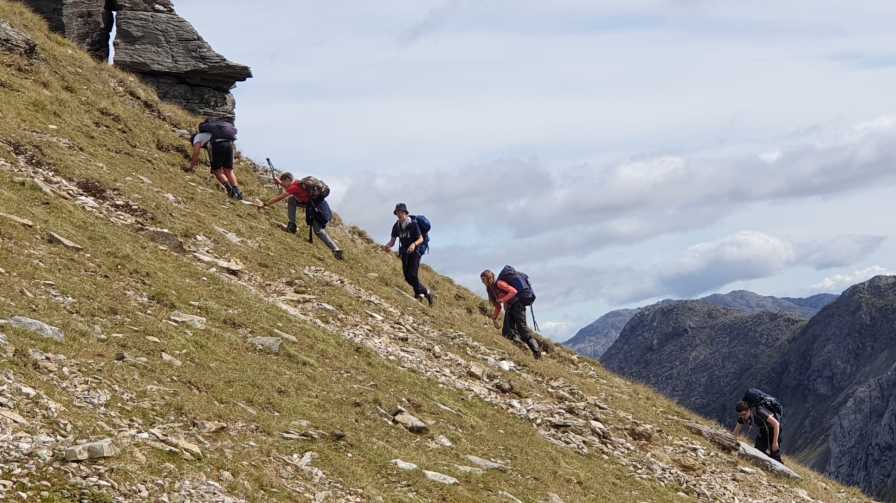
“What did you say”, enquired a youthful voice, “were you talking to us?” Ah yes, I had forgotten in my momentary paralysis. I was leading a group of scouts on the annual Connaught Mountain Pursuit Challenge event. I turned to see several pairs of eager eyes watching me, waiting for the signal to leave camp and begin our gruelling hike for the day. “And why do you look like a frightened hedgehog?” one astute scout asked.

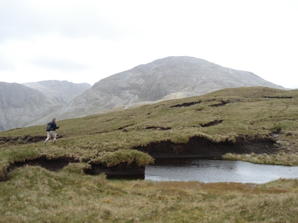
And so I learned once again how to navigate wet grass and high heather. I learned how to zig zag up steep scree slopes and descend to boggy cols. I learned how to breathe, how to stretch, how to manage a heart rate of 120, how not to fall over cliffs, and how not to stumble like a fool on perfectly flat and even ground. I learned how to suffer and I learned how to cope. And I learned how to lace and tie my boots.

Above all, as I descended to camp at the end of a tiring and joyful day, I learned how to once again gaze appraisingly at distant hills through eyes of chipped granite. The hedgehog was out of hibernation. Linkback: mountainviews.ie/summit/89/comment/23662/
Read Less
Read More

            MountainViews.ie picture about Benbaun (<em>An Bhinn Bhán</em>)
Picture: Peaty Knockpasheemore ridge and Ben Baun summit in background
White it is ...
by yambox 4 Aug 2011
Climbed Ben Baun and Ben Free on June 15th 2011.
From Kylemore Lough take right on the R344 towards Lough Inagh. Right after the woods, take the first small road right to Glencorbet (not indicated, only 5 houses).
There's space for about 5 cars on your right hand side after the bridge and before the first stable.
Follow the asphalt road until a 90 degree right turn and take left into the direction of Glencorbet farm. The most difficult part of the journey is crossing the river. Cross the river as soon as you see the opportunity. Some say you can cross 200 m before the farm, but I couldn't - I had to go back. Take your plastic boots with you or some fresh socks - just in case ...
After crossing the river, you have to go straight up Knockpasheemore Ridge (the slope in front of you and the river at your back). There is no clear path. The slope and the ridge itself are one big spunge. Watch your step on this massive heap of peat. During our journey it was very wet everywhere and I had wet feet ...
Once you're up the ridge, turn right and find your way through the peaty labyrinth towards the white rock of Ben Baun. Then straight up the white rock without any danger towards the windy top.
When you have little time but enough to do a small extra, go down to the west into the saddle between Ben Baun and Ben Free and hop up Ben Free in 10 minutes.
Back down into the saddle and downhill to the river at Glencorbet Farm. Be careful when descending from the saddle : before traversing to the right be sure you are deep enough to pass below the vertical rocks at the West face of Ben Baun.
Crossing the river at the same place and back to the car. This walk takes you around 3 hours - stops not counted. Linkback: mountainviews.ie/summit/89/comment/6462/
Read Less
Read More

Benbaun August 2013: On The Second Attempt
by jimhol53 4 Sep 2013
Attempted to climb Benbaun Friday August 30th 2013 at lunchtime but were unable to cross the Kylemore river. Would advise future climbers to check the speed and width of the river at the first crossing bridge before the car park (Glencorbet). Gave up altogether when low cloud made visibility poor. Returned Saturday morning to find the river passable in many places and visibility more than reasonable. Climbed with my son Philip to the summit and back in approx. 4 hours; it's interesting to note that we met no one on our entire journey around Benbaun (for the end of August, this seemed strange). The views were spectacular. I am attempting the highest peaks in each county and this leaves me with four to go. PS: this is most certaintly a climb that requires solid footwear and walking sticks as the ground changes by the minute underfoot and the initial part of the climb is quite steep. Linkback: mountainviews.ie/summit/89/comment/15169/
Read Less
Read More

            MountainViews.ie picture about Benbaun (<em>An Bhinn Bhán</em>)
Picture: Looking into Glencorbet, with Mweelrea behind
murphysw on Benbaun
by murphysw 11 May 2008
Driving along the R344 I noticed that there is new fencing all along the base of Knockpasheemore, as well as a lack of parking spaces. Glencorbet though, provides a good base for tackling the mountain. There is plenty of parking at Canclosn (L796 574). Follow the path towards the Glencorbet farmhouse, but about 200m before you reach this, cross the river at a bend where its easily crossed, then ascend the Knockpasheemore ridge. This ridge looks trickier to ascend the further you head into Glencorbet so best get it over with. The top of the ridge is undulating and covered in peat hags which luckily were dry. The great dome of Binn Bhan though is very stony. When I got to the summit the mist had momentarily moved in but I'd seen enough on the way up. The Bens are a most impressive range. A word of warning though, dont try and descend the ridge too early. I'd recommend going to about D (L796 553), or thereabouts, before heading down to the Kylemore river. I also noticed my compass stopped working on the way down the ridge. Despite looking across at Mweelrea and knowing that to be due north of me, the compass was showing that as east and Clifden as north. Strange, maybe time to invest in GPS! Linkback: mountainviews.ie/summit/89/comment/3095/
Read Less
Read More

            MountainViews.ie picture about Benbaun (<em>An Bhinn Bhán</em>)
simon3 on Benbaun
by simon3 5 Aug 2004
This visualisation shows the main twelve bens from the east. Linkback: mountainviews.ie/summit/89/comment/1051/
Read Less
Read More
EDIT Point of Interest
text
Videos


Recent Contributions
x
Conditions and Info
Use of MountainViews is governed by conditions and a privacy policy.
Read general information about the site.
Opinions in material here are not necessarily endorsed by MountainViews.
Hillwalking is a risk sport. Information in comments, walks, shared GPS tracks or about starting places may not be accurate for example as regards safety or access permission. You are responsible for your safety and your permission to walk.
See the credits and list definitions.

OSi logo
OSNI/LPS logo
Open Street Map
(Various variations used.)
British summit data courtesy:
Database of British & Irish Hills