Members and Supporters, the MountainViews Committee requests your help to meet the costs of the website and of other activities such as insured events or publications.
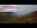
Antrim HillsArea, Cen: Central Antrim Hills
Subarea
Feature count in area: 27, all in Antrim,
OSI/LPS Maps: 14, 15, 4, 5, 8, 9
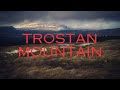
Highest Place: Trostan 550m
Starting Places (3) in area Antrim Hills: Donalds Carn, Rathlin Island Ferry Port, Whitehead Golf Club
Summits & other features in area Antrim Hills: Cen: Central Antrim Hills: Carncormick 436m, Collin Top 429m, Crockalough 402m, Mid Hill 440m, Skerry Hill 459m, Slieveanorra 508m, Slievenahanaghan 418m, Soarns Hill 403m, Tievebulliagh 402m, Trostan 550m Central Antrim Hills: Slievenanee 543m N: North Antrim Hills: Carnanmore 379m, Croaghan 417m, Crockaneel 403m, Cross Slieve 206m, Knocklayd 514m, Lannimore Hill 207m N: Rathlin Island: Kilpatrick (Rathlin Island) 134m S: Islandmagee: Donalds Carn 141m, Muldersleigh Hill 131m S: South Antrim Hills: Agnew's Hill 474m, Big Collin 353m, Black Hill 381m, Carnearny 319m, Douglas Top 402m, Slemish 437.9m W: West Antrim: Long Mountain 215m
Note: this list of places may include island features such as summits, but not
islands as such.
Tievebulliagh, 402mHill Taobh Builleach A name in Irish,
Place Rating ..
(Ir. Taobh (?)Builleach [NIPNP replies], 'beating/striking (mountain)side' or Taobh (?)Búilleach [NIPNP seminar], '(mountain)side of the clods/heavy ground'), Antrim County in Ulster province, in Carn Lists, Tievebulliagh is the 939th highest place in Ireland.
Grid Reference D19340 26821,
OS 1:50k mapsheet 5 Place visited by: 60members, recently by: Jonesykid, Paddym99, garybuz, Colin Murphy, Andy1287, atlantic73, dregishjake, LorraineG60, MichaelG55, Kilcoobin, Kilcubbin, dregish, eamonoc, FatPete, jimmy-mci
I visited this place: NO (You need to be a logged-in member for this.)
Longitude: -6.132441, Latitude: 55.074353, Easting: 319340, Northing: 426821,
Prominence: 57m, Isolation: 3.5km ITM: 719262 926804 Bedrock type: Olivine basalt lava, (Lower Basalt Formation) Notes on name: The first element of this name is clearly Ir. taobh, 'side'. The second element appears to be an adjective meaning 'beating' or 'striking', although this structure is slightly unusual. This name would be very apt as Tievebulliagh is the site of a Neolithic axe factory. Axes were made from a rare stone called porcellanite which outcrops only here on Tievebulliagh and at Brockley on Rathlin Island. They were an important item of exchange and were exported all over Ireland. Many also reached Britain by trade. For origin of name, see The Archaeology of Ulster by Mallory and McNeill, pp. 44-6. However, whether knowledge of the purpose of the axe factory continued in local folklore from the Neolithic to the modern day is open to some doubt. It is possible that the second word may rather be Ir. búilleach, 'heavy, soggy ground; clods' in the genitive plural, giving an alternative interpretation: '(mountain)side of the clods/heavy ground'.
Short or GPS IDs, 6 char: Tvblgh, 10 char: Tvblgh Linkback: https://mountainviews.ie/summit/819/
Gallery for Tievebulliagh (Taobh Builleach) and surrounds
Summary
for Tievebulliagh (Taobh Builleach):
Good, well-defined summit with excellent views
Summary created by Colin Murphy
2022-09-23 15:08:41
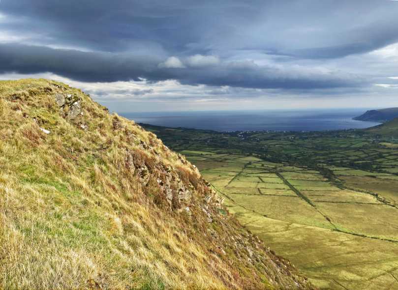
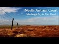
Picture: The coast is clear - summit area view
One relatively simple approach is from the north. There is parking for 1/2 cars between two farm gates, at A (D18767 27947) )although be careful not to block either gate. Cross the road to another gate, cross it and walk down the grassy track for about 70m until fence on left ends, then turn left down to the Glenann River. Cross river and proceed SE up the gentle slope (short grass underfoot & firm ground) for about 700m until you come to a gate. Go through this on to a track, turn left and walk about 100m to another gate on right at roughly B (D19366 27161). Go through this and proceed south up the grassy slope for about 300m, which from here on is a good deal steeper. The summit area is quite well defined but unmarked, and has fine views of Antrim coastline.
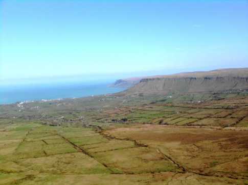
Picture: Looking east from Tievebulliagh summit towards Lurigethan
slemish on Tievebulliagh
by slemish
19 Apr 2009
As gerrym says access to Tievebulliagh from Cushendall is over private land so I decided to tackle the mountain from the other side. I parked at a sheep pen off the Orra scenic route between Cushendall and Newtowncrommelin, just beside the bridge over the Glendun river (C (D166 274)). From here I climbed over the hill marked Aghan on the OS map before heading down into a steep valley to cross the Glenaan burn. Heavy going at times, boggy and tussocky but nothing a decent pair of wellies can't cope with. Coming down the side of Aghan, Tievebulliagh stands proudly straight ahead of you - its rocky summit in sharp contrast to the 'rounded dome' characteristic of most of the Antrim hills. The climb up Tievebulliagh itself was easier due to firmer ground with only a few sheep for company. Eventually you approach the summit area which unfortunately has a lot of disused electrical equipment, including the remains of two aerials/antennas. From the summit at 402m the views are majestic - Glenballyeamon opens up beneath you with the almost sheer 150m drop to the valley floor not for the faint-hearted. Excellent views to the nearby Cross Slieve, Lurigethan, Crockalough, Trostan and Slieveanorra, then further still to Kintyre and Ailsa Craig. It was a beautiful afternoon and very warm indeed. I spent a good 20 minutes enjoying the sunshine at the summit before descending the north side of the mountain and picking up the Glenaan road back to the car. A very peaceful long walk and probably more interesting than the higher Antrim hills. Total trip about 2 hours. Linkback: mountainviews.ie/summit/819/comment/3724/
Read Less
Read More
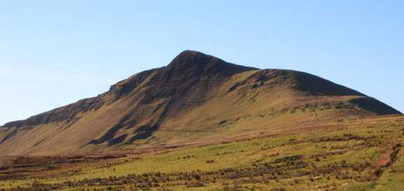
Picture: Looking south toward the final section to the summit
by welder
by Welder
22 Jun 2011
Took a quick walk up Tievebuillagh on a cloudy Sunday afternoon. Like gerrym I took the 'naughty' route from the minor road straight through the gate marked Private. About 1/4 mile back down the hill there is just room for a car beside an electricity sub-station.
Through the gate and a slowly rising laneway brings you under the north shoulder of the hill. I chose to go through a couple of gates and then attack directly up a steep flank. Despite this steep approach it only takes about 25 minutes thanks to the good conditions underfoot (unlike most Antrim hills). From the summit in less than perfect conditions I could make out the Mull of Kintyre, Sanda & Ailsa Craig to the east down the glen; Trostan to the south, Slievanorra to the west. Below the summit looking down the steep eastern face you can see the remains of the Neolithic mining operation, which continues to the north and back to the laneway. On this occasion I followed the fence near the cliff edge back to laneway, taking in some of the large boulders in the vicinity of the mine on the way. Very accessible hill with rewarding views for little effort. Linkback: mountainviews.ie/summit/819/comment/6387/
Read Less
Read More
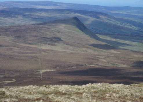
Picture: tievebulliagh
gerrym on Tievebulliagh
by gerrym
4 Nov 2007
I based this walk on that in 'Ulster Walk Guide' by Richard Rogers, a fantastic little book for anyone walking in the North of Ireland. I parked in the seaside town of Cusendall and endured a period of walking on the main road, alongside the river Dall, before turning off onto a minor road (D (D228 280)). A quick right turn brings an isolated lane which climbs steadily uphill, opening out views over the surrounding hills and out to sea. A gate is reached which warns of trespassing and not going further but having come this far i chanced my arm and whatever else may have been at risk. Now out in open hillside grazed heavily by sheep, the staple farming diet of the area. The object of desire is ahead and it does flaunt itself in a most shapely way, looking quite out of place amongst the rounded profiles of surrounding hills. There is a clear fenceline heading up over the shoulder of the hill which is handy to follow, with some steep climbing. At the base of the hill there is clear evidence of the ancient workings (axe factory). The going is very good on short cropped grass, thank you aforementioned sheep! There is the remains of an old radio mast/ariel at the top but it does not distract from the position and views - a great perspective on the surrounding high and low land and a feeling of loftiness when at the edge of the drop steeply down. I continued on from the summit, dropping down easily and then following a sea of heather to the S towards Trostan. Sea is a good word due to the wet nature of the ground, including areas of floating bog which had me wondering exactly what was beneath? After exploring the extensive top of Trostan i dropped down to the NE, past an area of rocky bluffs and then picking up a minor road dropping back down to Cusendall. Certainly one of the most impressive hills in Antrim, with many interesting features to keep interest. Linkback: mountainviews.ie/summit/819/comment/2883/
Read Less
Read More
Easy Access
by sandman
15 Nov 2012
Although the sign on the gate says private property there is no problem with access via Cloughs rd provided you abide by the country code. That is leave gates as you find them leave the dog at home as this is intensive sheep farming area . The road is used by numerous farmers and the ones myself and Muschi encountered had no problem with us accessing the summit. Linkback: mountainviews.ie/summit/819/comment/14874/
Read Less
Read More
Picture: Very distinctive!
NICKY on Tievebulliagh
by NICKY
12 Jun 2007
Tievebulliagh is an exceptional hill from any angle. The best route I would advise is to include it in my walk (see Slievanorra for the route). To do this, when you get to Trostan's summit simply look towards Tievebulliagh and follow the fence from Trostan to Tievebulliagh's western side then head straight for the top. The ground between the two is very boggy, tussocky and uncomfortable but it is worth it. When you have rested sufficiently on the summit just follow the fence back to Trostan to continue with my route. All in all an exceptional walk and a great day out! Linkback: mountainviews.ie/summit/819/comment/2736/
Use of MountainViews is governed by conditions and a privacy policy.
Read general information about the site. Opinions in material here are not necessarily endorsed by MountainViews.
Hillwalking is a risk sport. Information in comments, walks, shared GPS tracks or about starting places may
not be accurate for example as regards safety or access permission. You are responsible for your safety and your permission to walk.
See the credits and list definitions.


 Our Facebook page.