If you want to use the website often please enrol (quick and free) at top right.

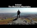
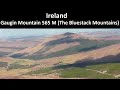
Croaghnageer 569.1m, Croaghanirwore 546.1m, Croaghnageer East Top 543.5m, Croaghconnellagh 523m, Croaghnageer North-East Top 521m, Croaghbarnes 498.8m, Brown's Hill 496.4m, Croaghonagh 451m, Cronamuck 444m, Croaghagranagh 440m,


 Get Notifications
Knocknakilton: Track most of the way.
 Collaborative entry
Lake District: The Dodds
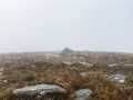
Gartan Mountain: A hill that punches above its weight
 kernowclimber
Lake District: Lingmoor Fell
Crockastoller: Isolated summit with marshy approaches
 Collaborative entry
Aghla More: Snow Moon
South West Coast Path West Cornwall
Ballinastraw: Undemanding stroll to the summit
 hibby
hibby
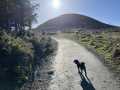
West Highland Way
Carrickgollogan: A hill close to my heart
 hibby
hibby
Use of MountainViews is governed by conditions and a privacy policy.
Read general information about the site.
Opinions in material here are not necessarily endorsed by MountainViews.
Hillwalking is a risk sport. Information in comments, walks, shared GPS tracks or about starting places may not be accurate for example as regards safety or access permission. You are responsible for your safety and your permission to walk.
See the credits and list definitions.
 Visit our Facebook page.
 Length: 8.8km, Creator time taken: 2h42m, Ascent: 493m,
Descent: 485m
Places: Start at H0403087338, Brown\'s Hill, Croaghnageer North-East Top, Croaghnageer East Top, end at Start
Logged as completed by 2

NOTE: ALL information such as Ascent, Length and Creator time taken etc should be regarded as approximate. The creator's comments are opinions and may not be accurate or still correct.
Your time to complete will depend on your speed plus break time and your mode of transport. For walkers: Naismith's rule, an approximate though often inaccurate estimate, suggests a time of 2h 35m + time stopped for breaks
NOTE: It is up to you to ensure that your route is appropriate for you and your party to follow bearing in mind all factors such as safety, weather conditions, experience and access permission.
* Note: A GPS Height in the elevation profile is sourced from the device that recorded the track. An "SRTM" height is derived from a model of elevations for parts of the earth. More detail![]()
|
|
|
||
| MountainViews.ie, a Hill-walking Website for the island of Ireland. 2400 Summiteers, 1480 Contributors, maintainer of lists: Arderins, Vandeleur-Lynams, Highest Hundred, County Highpoints etc | |||