This website uses cookies, which are small text files that the website puts on your device to facilitate operation. Cookies help us provide a better service to you. They are used to track general user traffic information and to help the website function properly.
Feature count in area: 15, all in Donegal,
OSI/LPS Maps: 1, 2, 6
Highest Place: Moylenanav 539m
Starting Places (28) in area Donegal Central: Astelleen Burn Waterfall, Ballyarr, Binnadoo, Braughan Road, Drumfin Bridge, Edenacarnan East, Edenacarnan North, Edenacarnan South, Garrangalta Rocks, Gartan Wood, Glenveagh Bridge, Glenveagh National Park SW, Glenveigh Castle, Losset North, Lough Acrobane Farmhouse, Lough Acrobane South, Lough Acrobane South West, Lough Barra Slipway CP, Lough Barra W, Lough Natooey West, Lough Salt North, Lough Salt West, Moyle Hill, Nabrackbaddy Lough, Parochial House, River Barra Bridge NE, River Barra Bridge SW, Sruhancrolee Bridge
Summits & other features in area Donegal Central: NE: Loughsalt Hills: Crockmore 349m, Croaghmore 278m, Edenacarnan 192m, Loughaskerry 252m, Loughsalt Mountain 469m, Moyle Hill 148m, Stragraddy Mountain 285m SW: Glendowan Mountains: Binswilly 337m, Brown Mountain 224m, Cionn Bheatha 384m, Crockastoller 418m, Farscallop 420.6m, Gartan Mountain 357m, Leahanmore 442m, Moylenanav 539m
Note: this list of places may include island features such as summits, but not
islands as such.
Crockastoller, 418mHill Cnoc an Stualaire A name in Irish,
Place Rating ..
(Ir. Cnoc an Stualaire [OSI], 'hill of the pile/standing stone'), Donegal County in Ulster province, in Carn Lists, Cnoc an Stualaire is the 857th highest place in Ireland. Cnoc an Stualaire is the second most southerly summit and also the second most westerly in the Donegal Central area.
Grid Reference B96200 10300,
OS 1:50k mapsheet 6 Place visited by: 16members, recently by: Colin Murphy, madfrankie, eamonoc, finkey86, Fergalh, Wilderness, hgboyle, David-Guenot, Garmin, ahendroff, Brambler, three5four0, Jht, leader1, Harry Goodman
I visited this place: NO (You need to be a logged-in member for this.)
Longitude: -8.060076, Latitude: 54.940259, Easting: 196200, Northing: 410300,
Prominence: 83m, Isolation: 3.1km ITM: 596150 910286 Bedrock type: Coarse biotite granite & granodiorite, (Main Donegal Granite) Notes on name: Cnoc an Stualaire / Crockastoller is a townland in the parish of Gartan. Crockastroller on the Discovery map sheet 6 is a mis-spelling. The correct form appears on sheet 1.
Short or GPS IDs, 6 char: Crckst, 10 char: Crckstlr Linkback: https://mountainviews.ie/summit/743/
Gallery for Crockastoller (Cnoc an Stualaire) and surrounds
Summary
for Crockastoller (Cnoc an Stualaire):
Isolated summit with marshy approaches
Summary created by Colin Murphy
2024-02-26 11:40:47
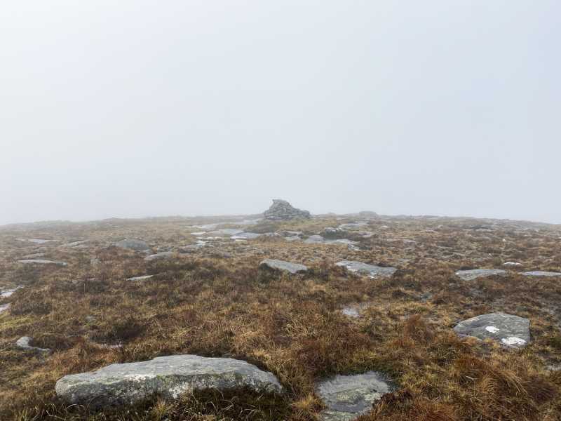
Picture: Summit cairn
This is a remote and isolated Carn almost 5km from the nearest road.
One approach is from the north, where there is parking for a single car by the side of the road at A (B95960 14988). See Moylenanav page for initial ascent. From there head directly south, dropping down to 300m in the col at point B (B96606 11883), where you’ll encounter a boggy, peat hag-riven area. Continue SSW up a gentler slope for 2km to reach the broad summit area, marked by a large cairn.
Alternatively you can approach from the SE starting at a forest entrance at point C (B99559 09737). Please be aware that although this minor road off the R250 appears on Google Maps, it is extremely rough (stone-littered and with multiple potholes) and great care should be taken driving it. Proceed up track, turn left almost immediately and then walk SW through woods for about 1km. The track ends in some rough but walkable ground that leads onto open hillside. Walk 2.5k NW across wet but navigable gently rising ground, at which point there is an area of peat hags for a few hundred metres. The last section is more grassy with the occasional small boulder before you arrive at the broad summit area. Allow four hours for the return trip.
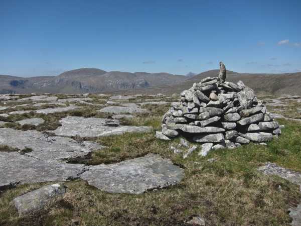
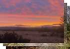
A fine view point indeed. From the Bluestacks to Slieve League & SlieveTooey round to Slieve Snaght, Bingorms, Drumnalifferny with Errigal poking over them to Moylenanav. Worth the long walk out for the view alone and not another walker in sight anywhere! Linkback: mountainviews.ie/summit/743/comment/5818/
Read Less
Read More
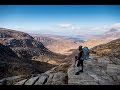
Picture: View from Crockastoller towards Moyleanav
No Crock of gold on this one
by eamonoc
23 Jan 2022
Up for a few days walking in Donegal, visited Moylenanav and took a look at Crockastoller away in the distance and decided to take the long trek out to it, headed towards west shoulder of Crocskakallabgh and dropped down steeply to an extremely wet boggy col riven with numerous peat hags, every step took complete concentration as the going was very wet and rough eventually reached drier ground closer to the top of Crockastoller 7km from starting point. A very remote top surrounded on all approaches by very boggy rough wet ground. Headed off in a northerly direction towards minor top Croaghacullin 435m OS sheet 6, the first km was over stony dry ground only to be followed by another km through torturous terrain where again peathags abound, steps carefully taken eventually lead to the stony top of Croaghacullin, followed by another wet 2km back to the start point. A tough very demanding 13km walk in the very wet Glendowan Mts. Linkback: mountainviews.ie/summit/743/comment/23391/
Read Less
Read More
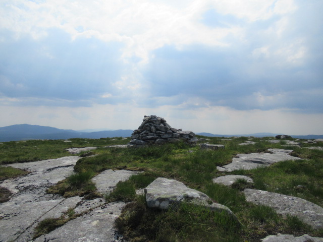
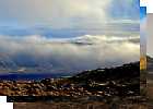
Picture: Crockastroller Summit
Hot day on Crockastroller
by Wilderness
1 Jul 2018
Beautiful views of the Bluestack mountains and the surrounding area.
I started my walk from the car park at Lough Barra and made my own way to the top of Moylenanav summit. I then walked the horseshoe in clockwise direction until I reached Crockastroller. From here I made my own way back to Lough Barra passing the small Croaghanarroo hill on my left.
The route passes by so many peat hags and some deep boggy ground in places, so be careful!!!
It was very hot and the horseflies were out on full force; they were an annoyance but they didn't ruin my day. Linkback: mountainviews.ie/summit/743/comment/19957/
Use of MountainViews is governed by conditions and a privacy policy.
Read general information about the site. Opinions in material here are not necessarily endorsed by MountainViews.
Hillwalking is a risk sport. Information in comments, walks, shared GPS tracks or about starting places may
not be accurate for example as regards safety or access permission. You are responsible for your safety and your permission to walk.
See the credits and list definitions.


 Our Facebook page.