This website uses cookies, which are small text files that the website puts on your device to facilitate operation. Cookies help us provide a better service to you. They are used to track general user traffic information and to help the website function properly.
Feature count in area: 14, all in Galway,
OSI/LPS Maps: 44, 45, EW-CON
Highest Place: Shannavara 358m
Starting Places (40) in area South Connemara: Angler's Return, Bealagrooaun, Brandy Harbour, Callanatrush Lough, Cashel Church, Cloonsie Quay, Cnoc Mordáin, Derroura Woods, Dogs Bay Beach, Drehidanookera Bridge, Drimmavohaun, Eragh Island South, Fuschia Lane, Glen Trasna Lough, Glencoaghan River Bridge, Gort Mór, Inaghbeg Path, Inchamakinna, Inishlay, Inishnee Bridge, Knockranny Road, Leitir Creamha Rua Lough, Lettercallow School Road, Lettershinna Hill, Loch Con Aortha N, Loch Con Aortha S, Lough Shindilla S, Maumwee Lough, Naughton's Property, Oorid Lough, Pound Road, Ross Quay, Roundstone, Screeb Waterfall, Seecon Wood, Tawnabeg Lough North, Tawnrawer Cartron, The Big Ring, Toombeola Bridge, Water Tank
Summits & other features in area South Connemara: Cen: Kilkieran: Cnoc Mordáin 354m E: Moycullen: Newtown Hill 198m N: Cashel: Cashel Hill 311m, Lettershinna Hill 192m N: Derroura: Cappanalaurabaun 273m, Keeraunnageeragh 305m N: Oughterard: Cloghermore 280m, Knocknasilloge 346m, Knocknalee 291m, Leam Hill 253m N: Shannavara: Knockadav 224m, Shannavara 358m S: Lettermore: Lettermore 117m W: Roundstone: Errisbeg 300m
Note: this list of places may include island features such as summits, but not
islands as such.
Errisbeg, 300mHill Iorras Beag A name in Irish,
Place Rating ..
(Ir. Iorras Beag [OSI], 'little peninsula'), Galway County in Connacht province, in Binnion Lists, Iorras Beag is the 1163th highest place in Ireland. Iorras Beag is the most westerly summit in the South Connemara area.
Grid Reference L69763 40146,
OS 1:50k mapsheet 44 Place visited by: 105members, recently by: srr45, DeirdreM, TipsyDempy, maitiuocoimin, Lgr, bryanmccabe, Geansai, eiremountains, chelman7, Krumel, GoldCircle, Lauranna, ochils_trekker, brendanjrehill, TommyMc
I visited this place: NO (You need to be a logged-in member for this.)
Longitude: -9.958588, Latitude: 53.39562, Easting: 69763, Northing: 240146,
Prominence: 275m, Isolation: 10.9km, Has trig pillar
ITM: 469741 740172 Bedrock type: Hornblende metagabbros & metanorites, (Metagabbro and Related Lithologies) Notes on name: This solitary hill is the only peak of any height near Roundstone, making it easy to recognise from as far away as the Burren. Roderic O'Flaherty wrote of its conspicuous position in 1684: Westward of Inisnee and Round-stone haven, in Inisleth-dhuine [identified by the editor, Hardiman, as the modern Inis Leacainn or Shelving Island], a small island which leads to Irrosbeg haven, called Portnafedoigge [Port na Feadóige, 'harbour of the grey plover']; over which is Irrosbeg hill, the second place discovered by marriners [after the Twelve Bens] coming from the sea, on top of which is a poole where trouts breed (O'Flaherty, 108). Iorras Beag is also one of the habitats of the rare Mackay's heath and St. Dabeoc's heath. Walks: for routes to the summit of Errisbeg from the W side, see Kevin Corcoran, West of Ireland Walks, 72-80, or Whilde & Simms, New Irish Walk Guide - West and North, 31.
Short or GPS IDs, 6 char: Ersbg, 10 char: Errisbeg Linkback: https://mountainviews.ie/summit/957/
Gallery for Errisbeg (Iorras Beag) and surrounds
Summary
for Errisbeg (Iorras Beag):
Panoramic views of Connemara
Summary created by liz50
27 Mar, 2017
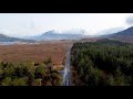
Picture: Summit Area
A pleasant 2 hour walk from Roundstone village by taking a minor road to the west from the centre of the village. There is parking along this road at Fusch Ln (L71775 40102). Continue on ungraded road to a wooden gate at A (L71295 40206) giving access to the open hillside. Summit area has a trig point and a second 'high point' with a cairn.
Also possible to park on the R341 at B (L68279 39762) and follow a bog road leading North before heading to the summit
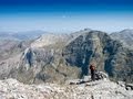
Picture: Panoramic vista from Errisbeg - the Twelve Pins
A very rewarding short climb in Connemara
by ochils_trekker
28 Mar 2021
Errisbeg is an unremarkable looking hill from any angle, but the views of Dogs Bay, Inishnee and most of all the Twelve Pins are truly outstanding on a good day. I have walked it a couple of times, on both occasions from Roundstone. At the harbour, turn up the road at O'Dowds pub and restaurant -well worth a visit for a pint and food on the way back. Just follow this road until a gate next to a house is reached and this leads on to the open hillside. It is then just picking a route and keeping the top visible where possible, as it is easy to meander a bit with the constant changes in the terrain from rocks to grass and heather. The view opens up very quickly so the ascent is always enjoyable in good conditions. An easy to moderate walk, and you can be up and down within three hours or so. You will probably want to linger for the stunnng Connemara views on a half-decent day though. Linkback: mountainviews.ie/summit/957/comment/22722/
Read Less
Read More
Picture: Distant
weedavie on Errisbeg
by weedavie
25 Aug 2008
Errisbeg is indeed a wee cracker. In not too much more time than Simon suggests, you can traverse it West to East dropping down into Roundstone, have a couple of pints and some prawns, stop for a swim at Dog's Bay and walk back along the road to your car. Or, if the road looks too long or too busy, have a bike stashed and send the most energetic member of the party to retrieve it.
But I'm waiting for screams of rage from pedantic geographers at the transfer of this hill to the Twelve Pins (or 12.5 Pins as they'll certainly have to be renamed.) The photy is of the distant Pins from Roundstone at the foot of Errisbeg. Linkback: mountainviews.ie/summit/957/comment/3272/
Read Less
Read More
Picture: View from Errisbeg.
simon3 on Errisbeg
by simon3
20 Aug 2008
Errisbeg has fine views over the intricate patchwork of water and land that is Roundstone Bog to its north. One way of getting up it is to start to its southwest at B (L68279 39762), which is reached by going west out of Roundstone past its slopes and parking beside the road. A bog road leads north from around there.
At an admitedly fairly leisurely place it took our party over 4 hours to get up and down over the distance of only 4.8k there and back. So we found the walk surprisingly time-consuming for such a small height gain. The land is extremely rough in places.
Another wonderful day with the weather here and it was the ideal day to hike to the summit of Errisbeg in Roundstone. I was pleasantly surprised how quickly I got to the summit, I thought it would take longer today but not the case. It was well under an hour. I had a wonderful snack whilst gazing down at such scenery.
The scenery is just stunning and the elevated views of Dog's Bay Beach are nothing short of astounding. Great to see some other hikers out and about this afternoon and there are many large rocks at the top to sit down and gaze and this wonderful picture-postcard setting. I could even see portions of the Lower Sky Road today in the distance. Linkback: mountainviews.ie/summit/957/comment/20324/
Read Less
Read More
Picture: Dogs Bay & Gorteen Bay
Splendidly isolated
by TommyV
29 Oct 2018
Access to this hill is from a farm trail on the West side heading along the R341 at C (L68410 39753). After following the track for a few hundred meters at D (L68095 40424), it's a matter of simply picking your route to the East up the open hillside to the trig point at 300 metres. As Errisbeg is so far removed to the West of the other peaks in Connemara, the views back over to them are great. And as for the views of the beaches below to the South...... Linkback: mountainviews.ie/summit/957/comment/20105/
Use of MountainViews is governed by conditions and a privacy policy.
Read general information about the site. Opinions in material here are not necessarily endorsed by MountainViews.
Hillwalking is a risk sport. Information in comments, walks, shared GPS tracks or about starting places may
not be accurate for example as regards safety or access permission. You are responsible for your safety and your permission to walk.
See the credits and list definitions.


 Add a Place Comment for Errisbeg, Iorras Beag


 Our Facebook page.