Cookies.
This website uses cookies, which are small text files that the website puts on your device to facilitate operation. Cookies help us provide a better service to you. They are used to track general user traffic information and to help the website function properly.
Features
Nearby features appear when you click the map.
Declutter tracks on map.
Place Search
Video
X
Pub: by
South Connemara Area , N: Cashel Subarea
Feature count in area: 14, all in Galway, OSI/LPS Maps: 44, 45, EW-CON
Highest Place: Shannavara 358m

Starting Places (40) in area South Connemara:
Angler's Return, Bealagrooaun, Brandy Harbour, Callanatrush Lough, Cashel Church, Cloonsie Quay, Cnoc Mordáin, Derroura Woods, Dogs Bay Beach, Drehidanookera Bridge, Drimmavohaun, Eragh Island South, Fuschia Lane, Glen Trasna Lough, Glencoaghan River Bridge, Gort Mór, Inaghbeg Path, Inchamakinna, Inishlay, Inishnee Bridge, Knockranny Road, Leitir Creamha Rua Lough, Lettercallow School Road, Lettershinna Hill, Loch Con Aortha N, Loch Con Aortha S, Lough Shindilla S, Maumwee Lough, Naughton's Property, Oorid Lough, Pound Road, Ross Quay, Roundstone, Screeb Waterfall, Seecon Wood, Tawnabeg Lough North, Tawnrawer Cartron, The Big Ring, Toombeola Bridge, Water Tank

Summits & other features in area South Connemara:
Cen: Kilkieran: Cnoc Mordáin 354m
E: Moycullen: Newtown Hill 198m
N: Cashel: Cashel Hill 311m, Lettershinna Hill 192m
N: Derroura: Cappanalaurabaun 273m, Keeraunnageeragh 305m
N: Oughterard: Cloghermore 280m, Knocknasilloge 346m, Knocknalee 291m, Leam Hill 253m
N: Shannavara: Knockadav 224m, Shannavara 358m
S: Lettermore: Lettermore 117m
W: Roundstone: Errisbeg 300m

Note: this list of places may include island features such as summits, but not islands as such.
Rating graphic.
Cashel Hill, 311m Hill Cnoc an Chaisil A name in Irish,
Place Rating ..
(Ir. Cnoc an Chaisil [OSI], 'hill of an Caiseal or the stone
ring-fort')
, Galway County in Connacht province, in Binnion Lists, Cashel Hill is the 1139th highest place in Ireland. Cashel Hill is the second most westerly summit in the South Connemara area.
Grid Reference L80036 43672, OS 1:50k mapsheet 44
Place visited by: 57 members, recently by: oakesave, trekker, jlk, garrettd, Joshua3, TommyMc, Geo, blowin, Damian120, TommyV, conormcbandon, Haulie, paulbrown, Wilderness, mdoc1969
I visited this place: NO (You need to be a logged-in member for this.)
Longitude: -9.805584, Latitude: 53.4297, Easting: 80036, Northing: 243672, Prominence: 285m,  Isolation: 3.1km, Has trig pillar
ITM: 480012 743695
Bedrock type: Hornblende metagabbros & metanorites, (Metagabbro and Related Lithologies)
Notes on name: Cashel / An Caiseal is the name of a settlement south of the hill, and also a townland. The townland is named from the earth- and stone-banked 'ringfort' or cashel surrounding the old cemetery in Caiseal Ard / High Cashel. This is probably an Early Christian religious site (TR, 72). Walks: for a route to the summit from the SW, see Whilde & Simms, New Irish Walk Guide - West and North, 30.
  Short or GPS IDs, 6 char: CshlHl, 10 char: Cashel Hil

Linkback: https://mountainviews.ie/summit/947/
Gallery for Cashel Hill (Cnoc an Chaisil) and surrounds
Summary for Cashel Hill (Cnoc an Chaisil): Connemara in the Sun
Summary created by liz50, Buny Clare 2017-03-27 13:20:29
            MountainViews.ie picture about Cashel Hill (<em>Cnoc an Chaisil</em>)
Picture: Cashel Hill
Climbed on Tuesday 07th June , 2 hrs 45min return. I went up the track from the road after the entrance to Cashel House Hotel and just before the church Cash Ch (L80303 42385). Walked past the graveyard and through 2
gates to A (L80749 43076) and walked around the base of the hill to the South Side I actually went too far south as it was not necessary , the southern side is more challenging . Great views of the Bens and Mamturks.
I did not return the same way and came all the way down the South side directly to the gardens of the Castle House Hotel. Before the Hotel grounds , I was delayed for 10 mins looking for a gate in order to avoid having the climb the stone wall. I would say it could be a very wet boggy walk in normal weather but the recent long dry weather made it easy on the foot.
Linkback: mountainviews.ie/summit/947/comment/5706/
Member Comments for Cashel Hill (Cnoc an Chaisil)

            MountainViews.ie picture about Cashel Hill (<em>Cnoc an Chaisil</em>)
Picture: The rocky upper part of Cashel Hill is good for some clambering.
Hill by the bay
by fieldoptic 30 Sep 2022
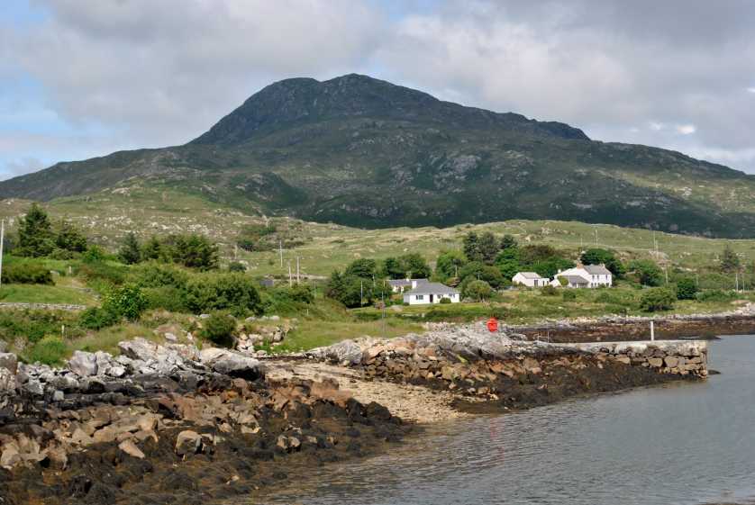
Parking at the church at Cash Ch (L80303 42385) 
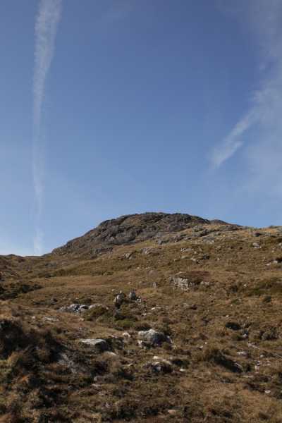
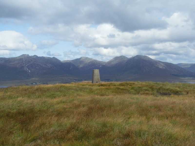
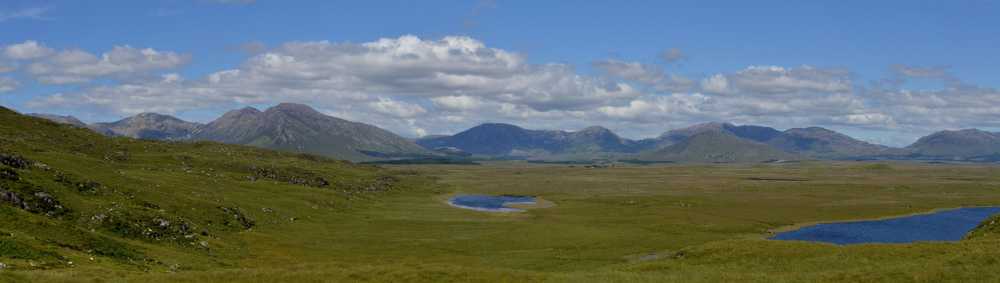
you can pass through the gate to the left side of the church as you face it, up the slope. This boithrín leads to the graveyard at 
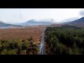
B (L80714 42976). The graveyard contains the easily discernible circular ditch of the original Caisel or Ringfort that gives the hill and townland its name. To the north of the graveyard through a gate is a maintained holy well. Passing the graveyard on your right hand side you can go through a gate onto open ground and the hill rises away to your left. The lower slopes are easily traversed being grassy but there's a decent rocky clamber to the top. Views are excellent in all directions with the full southern flank of the Bens laid out before you, Lissoughter and the Maams, Roundstone bog, Errisbeg, and the bays to the south, all beautifully arranged. This is also fantastic spot to watch a sunset over the lakes of Roundstone Bog or the Bens if you're properly equipped with torches for a descent in the late dusk.

For extra interest, though out of the way of the best route there is one of the surprisingly few megalithic sites in Connemara on the SE flank of the hill at C (L79279 43217), a wedge tomb, well preserved.

Cashel hill, could be taken in in a day including Errisbeg & Cnoc Mordáin as suggested finishing with a drink O'Dowd's of Roundstone maybe Linkback: mountainviews.ie/summit/947/comment/17975/
Read Less
Read More

walk info
by fkaatje 14 Jan 2012
Cashel Hill is a nice short hill walk. Easy access and excellent views. Can easily be done in 2 hours. For a full day in the hills consider combining it with one of the other great viewpoints in this area. Errisbeg and Cnoc Mordain are both under 20 minutes by car.

I found a detailed description of the walk at http://www.roundstone-connemara.com/Roundstone-Walking-Courtesy-of-the-Roundstone-House-Hotel/Cashel-Hill-Walk.html. I left my GPS track at http://www.wikiloc.com/wikiloc/user.do?name=fkaatje. Linkback: mountainviews.ie/summit/947/comment/6654/
Read Less
Read More

Access info.
by vanczyz 6 Jul 2010
Access is really easy. On the left hand side of the church behind the gate there is a nice easy road that takes you up to the old cemetery. You might leave your bicycle at the start or take it with you to the end of this road. This walk on foot takes 10/15 minutes. From the cemetery to the hill, the way is also easy. It is unmarked, but this is not a problem, as there is no other hill around ;). After maybe 30 minutes you can reach the top. I've just come back from there. Really nice views: Twelve Pins, Maumturk Mnts and south Connemara. Linkback: mountainviews.ie/summit/947/comment/5923/
Read Less
Read More

            MountainViews.ie picture about Cashel Hill (<em>Cnoc an Chaisil</em>)
Picture: Trig point looking directly across to the Glencoghan Horseshoe.
Big rewards for little effort.
by TommyV 29 Oct 2018
The church mentioned by liz050 is a good place to park for this hike or If you are pressed for time it's possible to drive to the graveyard. At the graveyard there is a gate that leads out to the open hillside. A short steep climb North West will take you to the summit of the hill. The views of the Maumturks and the Twelve Bens from here are second to none. A fantastic little gem of a hill. Linkback: mountainviews.ie/summit/947/comment/20106/
Read Less
Read More

            MountainViews.ie picture about Cashel Hill (<em>Cnoc an Chaisil</em>)
One of the finest views in the west of Ireland
by Damian120 6 Jan 2019
Follow the directions as detailed by the other contributors and once you are through both gates I would immediately continue on the ascent as the full impact of that remarkable Connemara vista will hit you full on. It's stunning. I've been there four times now and hope to do it again as for the life of me I cannot locate the Scrahallia Wedge Tomb which is located at the foot of Cashel Hill. Not the most challenging of hikes but trust me the scenery is striking. Linkback: mountainviews.ie/summit/947/comment/20322/
Read Less
Read More
EDIT Point of Interest
text
Videos


Recent Contributions
x
Conditions and Info
Use of MountainViews is governed by conditions and a privacy policy.
Read general information about the site.
Opinions in material here are not necessarily endorsed by MountainViews.
Hillwalking is a risk sport. Information in comments, walks, shared GPS tracks or about starting places may not be accurate for example as regards safety or access permission. You are responsible for your safety and your permission to walk.
See the credits and list definitions.

OSi logo
OSNI/LPS logo
Open Street Map
(Various variations used.)
British summit data courtesy:
Database of British & Irish Hills