This website uses cookies, which are small text files that the website puts on your device to facilitate operation. Cookies help us provide a better service to you. They are used to track general user traffic information and to help the website function properly.
Summits & other features in area North East Midlands: Cen: Ballyjamesduff: Aghalion Hill 249m Cen: Oldcastle: Mullaghmeen 258m, Slieve Na Calliagh 276m, Spire of Lloyd 131m, The Hill of Mael 241m E: Kingscourt: Carrickleck Hill 173m N Cen: Cavan Town: Shantemon 218m, Slieve Glah 320m, Tievenanass 261m NE: Ballybay: Bunnanimma 268m NE: Carrickmacross: Corduff 243m NE: Castleblaney: Mullyash Mountain 317m NE: Cen Bailieborough: Cornasaus 339m, Taghart South 290m NW Cen: Arva: Bruse Hill 260m NW: Aughavas: Lugganammer 190m S Cen: Crookedwood: Cruckboeltane 199m, Knockeyon 214m S: Westmeath South West: Knockastia 200m SE: Boyne Valley: Hill of Slane 160.4m, Mount Oriel 251m, Tara 155m W: Ardagh: Bawn Mountain 200m W: Drumlish: Corn Hill 278m
Note: this list of places may include island features such as summits, but not
islands as such.
Slieve Glah, 320mHill Sliabh gCleath A name in Irish,
Place Rating ..
(Ir. Sliabh gCleath [logainm.ie], 'mountain of wattle'), Cavan County in Ulster province, in Binnion Lists, Slieve Glah is the second highest hill in the North East Midlands area and the 1114th highest in Ireland.
Grid Reference H46182 00817,
OS 1:50k mapsheet 34 Place visited by: 42members, recently by: oakesave, Lauranna, MickM45, Jai-mckinney, Oscar-mckinney, Carolyn105, trostanite, abcd, TommyV, TommyMc, DeltaP, conormcbandon, Garmin, jackill, chalky
I visited this place: NO (You need to be a logged-in member for this.)
Longitude: -7.296743, Latitude: 53.954414, Easting: 246182, Northing: 300817,
Prominence: 205m, Isolation: 6.7km, Has trig pillar
ITM: 646158 800796 Bedrock type: Siltstone, mudstone & thin turbidite, (Slieve Glah Formation) Notes on name: Slieve Glah, near Cavan Town, is the highest point in Central Co. Cavan. It has fine views Lough Sheelin, Lough Gowna, Lough Oughter and Upper Lough Erne. There is a Giant's Grave on Slieve Glah; and a big stone at Lavey two miles east is said to have been thrown by the Slieve Glah giant at his brother in Lavey (Máire MacNeill, 'The Festival of Lughnasa', p. 174).
Short or GPS IDs, 6 char: SlvGlh, 10 char: SlvGlah Linkback: https://mountainviews.ie/summit/932/
Gallery for Slieve Glah (Sliabh gCleath) and surrounds
No summary yet for this place
.
Add a Place Comment for Slieve Glah, Sliabh gCleath (932) in Area: North East Midlands, N Cen: Cavan Town, County: Cavan, N Cen: Cavan Town
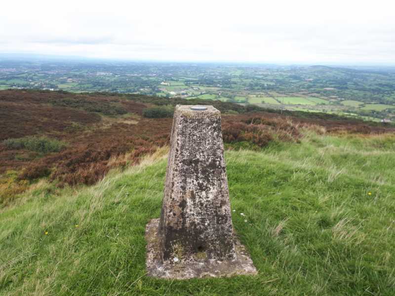
Parked at a farmyard on the South East side of the hill. Met a friendly young guy, the land owners son I assume and he showed us the way to access the hill at A (H47142 00418). It's a farm track that is also used as a Vodaphone access road that leads to the masts at the top of the hill. At the start this does not even look like a road that vehicles could access, it really is more of a field but rest assured this is the way up. The trig point is about 100 metres behind the masts. This is trickier to get to than you would expect. At the masts I went to the right to circle the compound. Do not do this, unless you want to fight through chest high briars and furs and even a wire fence covered in furs. Hop a wall on the left hand side of the masts, your body will thank you for it! Linkback: mountainviews.ie/summit/932/comment/20191/
Read Less
Read More
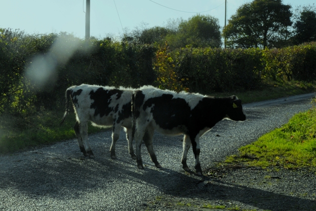
Picture: Reluctant Calfs Slieve Glah
Strong Calves required
by eamonoc
2 Nov 2013
Thursday 31/10/2013. Using comments from Mt Views for directions I arrived at the access track for Slieve Glah, got out of car and met a local farmer, he was about to let a herd of calfs out of a field just across the road from the access path and into a field beside the access path. I spoke to him and he asked me to help him get the calfs across the road, so I duly obliged. when the cattle were safely across the road and into the field, the farmer told me there was no problem with climbing this hill. It took about 20mins on a good path to climb Slieve Glah, the trig point is uphill behind the masts. Headed back to car and onto Bruse Hill. Linkback: mountainviews.ie/summit/932/comment/15242/
Read Less
Read More
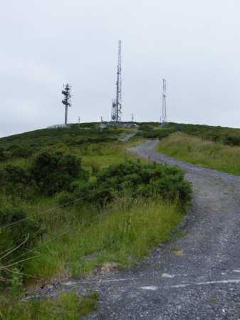
Picture: Slieve Glah masts
paddyhillsbagger on Slieve Glah
by paddyhillsbagger
21 Jun 2009
Hooray for local hills! Despite tending to the garden in the morning and training for the Tri-Athlone in the afternoon, I still had time (and energy) to bag a climb!
I accessed Slieve Glah from the south on a minor road off the Cavan to Ballyjamesduff road. There are a plethora of communication masts and a rough track up to them. The trig point is about 100m beyond these masts up a rise. There are no clear paths beyond the masts and I had to fight through gorse and heather to get to the trig!
The views are worth the short discomfort and I followed a rough trail back down to the masts which exited to the left of the 2 masts on the right (looking down from the top) which was easier, but short trousers are not recommended! Linkback: mountainviews.ie/summit/932/comment/3871/
Read Less
Read More
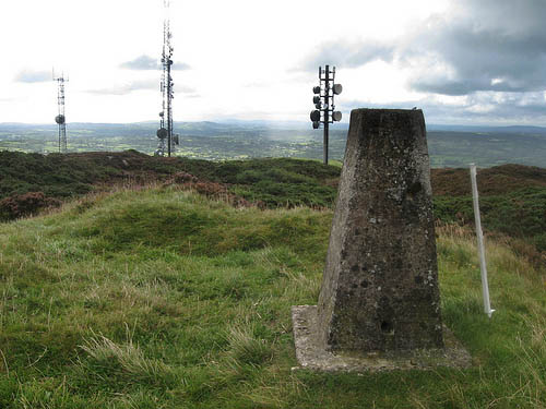
Picture: The view from Slieve Glah - note the plastic curtain rail.
Fills your heart with glahness.
by madfrankie
5 Sep 2010
Slieve Glah is a small, but visible hill south of Cavan town near the village of Crosskeys. The map suggests two access tracks, but I could only find the start of the more convoluted longer track.
It's twenty minutes up to the telecoms masts, and as Paddyhillsbagger says, plenty of gorse near the summit. Linkback: mountainviews.ie/summit/932/comment/6084/
Use of MountainViews is governed by conditions and a privacy policy.
Read general information about the site. Opinions in material here are not necessarily endorsed by MountainViews.
Hillwalking is a risk sport. Information in comments, walks, shared GPS tracks or about starting places may
not be accurate for example as regards safety or access permission. You are responsible for your safety and your permission to walk.
See the credits and list definitions.


 Add a Place Comment for Slieve Glah, Sliabh gCleath


 Our Facebook page.