Cookies.
This website uses cookies, which are small text files that the website puts on your device to facilitate operation. Cookies help us provide a better service to you. They are used to track general user traffic information and to help the website function properly.
Features
Nearby features appear when you click the map.
Declutter tracks on map.
Place Search
Video
X
Pub: by
Boggeragh Mountains Area , N: Banteer Subarea
Feature count in area: 11, all in Cork, OSI/LPS Maps: 79, 80
Highest Place: Musheramore 642.7m

Starting Places (8) in area Boggeragh Mountains:
Butter Road, Duhallow Way, Derry Wood, Glannaharee East Woods S, Laharan Woods N, Millstreet Country Park, Mount Hillary Wood N, Mount Hillary Wood W, St John's Well

Summits & other features in area Boggeragh Mountains:
Cen: Seefin: Knockcraugh 434m, Seefin 491m, Seefin East Top 491m
N: Banteer: Mount Hillary 391m, Tooreen 322m
NE: Bweeng: Bweeng Little 414m, Bweengduff 416m
S: Macroom Hills: Burren 380m, Knockagreenan 263m
W: Musheramore: Musherabeg 498.8m, Musheramore 642.7m

Note: this list of places may include island features such as summits, but not islands as such.
Rating graphic.
Mount Hillary, 391m Hill Mullach Allaíre A name in Irish,
Place Rating ..
(Ir. Cnoc an Iolair [PNABD*], 'hill of the eagle'), Cork County in Munster province, in Binnion Lists, Mount Hillary is the 976th highest place in Ireland. Mount Hillary is the most northerly summit in the Boggeragh Mountains area.
Grid Reference W42527 95648, OS 1:50k mapsheet 80
Place visited by: 64 members, recently by: jeb, Padraigin, Leatra, DeirdreM, markmjcampion, Glanman2, dregish, Causticblonde, caiomhin, mlmoroneybb, maryblewitt, mh400nt, nolanlyn, John.geary, AlisonM
I visited this place: NO (You need to be a logged-in member for this.)
Longitude: -8.839616, Latitude: 52.110246, Easting: 142527, Northing: 95648, Prominence: 176m,  Isolation: 4.6km, Has trig pillar
ITM: 542489 595705
Bedrock type: Red conglomerate, sandstone & mudstone, (Old Red Sandstone (undifferentiated))

  Short or GPS IDs, 6 char: MntHlr, 10 char: MntHlry

Linkback: https://mountainviews.ie/summit/852/
Gallery for Mount Hillary (Mullach Allaíre) and surrounds
Summary for Mount Hillary (Mullach Allaíre): Eagles Hill
Summary created by jackill 04 Feb, 2011
            MountainViews.ie picture about Mount Hillary (Mullach Allaíre)
Picture: East from the Cross
Park at the forest entrance just above Fr Murphys Bridge outside Banteer MtHilary WdW (W39408 96108), room for 6 cars. Walk up the forest track , turn right , then right , the right again on a good track all the way to the summit. Note the track starting at A (W41024 95949) is now covered in brush from felled trees but can be reached if you turn off the road at approx. B (W41277 96000). The summit is marked by 4 masts and a trig pillar.The best views are to be had by continuing to C (W43080 95236) and heading east through the forest on the south side of the ride , then across a field to the cross at D (W43593 94840).
Linkback: mountainviews.ie/summit/852/comment/5611/
Member Comments for Mount Hillary (Mullach Allaíre)

            MountainViews.ie picture about Mount Hillary (Mullach Allaíre)
Picture: The track to the east summit and the cross (just visible)
A short but fun trip to the top
by thomas_g 9 Feb 2012
Park at MtHilary WdN (W42251 97135) (room for 6 cars). Head straight up the hill, ignoring the walking trail markers. At the T junction at E (W42128 96588), enter the woods behind the information board, there is a visible trail. Now climb up the stream bed, which is steep in spots and could be very wet after lots of rain. When you emerge on the forest track at the top, turn left and then next right, you are following the red marked trail in reverse now.
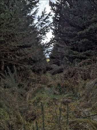
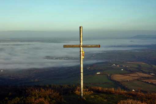
Still following the marked trail. after taking a right you'll come to a cross of forest tracks, the summit is straight on, but if you want to head for the cross, turn left here (sorry no grid ref) and at F (W43040 95272) enter the woods, you'll see from the picture below that the track that was once there is now impassible (I passed it twice even with a GPS ref). You'll need to parallel the track through the woods and soon the cross will come into view. It's a worthwhile detour, the views are pretty decent.
Having back tracked to the summit, I started a very windy descent along the marked track so I entered the woods again at G (W42284 95688) following a rough path down through the trees to another forest track at H (W42159 95934), cross straight across and before long you'll be back at the top of the stream bed from earlier. I followed the blue marked trail back to the car, but the more adventurous could go back down the stream bed. Linkback: mountainviews.ie/summit/852/comment/6677/
Read Less
Read More

            MountainViews.ie picture about Mount Hillary (Mullach Allaíre)
Picture: View from cairn near cross towards summit area.
Forested top.
by simon3 4 Feb 2011
From near the cross D (W43593 94840) this is the view NW towards the main summit which as you can see in the picture has various telecom towers on it. Linkback: mountainviews.ie/summit/852/comment/6233/
Read Less
Read More

            MountainViews.ie picture about Mount Hillary (Mullach Allaíre)
Picture: galtees from the Boggeraghs
rossbeighed on Mount Hillary
by rossbeighed 6 Dec 2008
the view of galtymore from mount hillary.. Linkback: mountainviews.ie/summit/852/comment/3470/
Read Less
Read More

salee on Mount Hillary
by salee 3 Dec 2008
gentle walking along coillte tracks, access from carpark on the north or west, several way-marked ways in different colours for different lengths - all very easy. Linkback: mountainviews.ie/summit/852/comment/3463/
Read Less
Read More

            MountainViews.ie picture about Mount Hillary (Mullach Allaíre)
Picture: Mt Hillary east
rossbeighed on Mount Hillary
by rossbeighed 6 Dec 2008
Climbed Mount hillary from the North from the coillte forest opening south of banteer. there is a map of the walks at the entrace.
There are actually two peaks btw. on the east its marked by a cross looking east towards mallow, on the west is the highest point looking west towards mushera and claragh mountain. the trig pillar here registers 1280 feet on my altitude watch but dont know how accurate that is.
have to say the views were great for such a small effort. Linkback: mountainviews.ie/summit/852/comment/3469/
Read Less
Read More
EDIT Point of Interest
text
Videos
Recent Contributions
x
Conditions and Info
Use of MountainViews is governed by conditions and a privacy policy.
Read general information about the site.
Opinions in material here are not necessarily endorsed by MountainViews.
Hillwalking is a risk sport. Information in comments, walks, shared GPS tracks or about starting places may not be accurate for example as regards safety or access permission. You are responsible for your safety and your permission to walk.
See the credits and list definitions.

Open Street Map
(Various variations used.)
British summit data courtesy:
Database of British & Irish Hills
Height layer: © MapTiler
MapTiler Logo
MountainViews.ie is a Hill-walking Website for the island of Ireland. 2500 Summiteers, 1480 Contributors, maintainer of lists such as: Arderins, Vandeleur-Lynams, Highest Hundred, County Highpoints.