Cookies.
This website uses cookies, which are small text files that the website puts on your device to facilitate operation. Cookies help us provide a better service to you. They are used to track general user traffic information and to help the website function properly.
Features
Nearby features appear when you click the map.
Declutter tracks on map.
Place Search
Video
X
Pub: by
East Mayo Area , NW: Pontoon Hills Subarea
Feature count in area: 15, all in Mayo, OSI/LPS Maps: 23, 24, 31, 32
Highest Place: Nephin 806m

Starting Places (13) in area East Mayo:
Bellanaderg Bridge, Cloondaff Church, Cuilkillew S, Glasheens River, Gortnadrehy South, Gortnadrehy West, L5709 Lugnamannaun River, Lough Ben, Loughanaveeny, Nephin CP Fiddaunduff, Nephin CP Forest Road, R312 Boghadoon, R312 Prughlish

Summits & other features in area East Mayo:
E: Charlestown Hills: Knock Hill 213m, Mullaghanoe 234m
N: Foxford Hills: Carranarah 197m, Gortnadrehy 143m
NW: Nephin: Cuilkillew 130m, Nephin 806m, Tristia 322m
NW: Pontoon Hills: Crucknaree 297m, Farbreiga 395m, Knockaglana 154m
S: Kiltimagh Hills: Rush Hill 197m, Slieve Carn 262m
W: Croaghmoyle: Burren 396m, Croaghmoyle 430m, Muckanagh Hill 220m

Note: this list of places may include island features such as summits, but not islands as such.
Rating graphic.
Farbreiga, 395m Hill Fear Bréige A name in Irish,
Place Rating ..
(prob. Ir. Fear Bréige [PDT], 'false man'), Mayo County in Connacht province, in Binnion Lists, Farbreiga is the 969th highest place in Ireland.
Grid Reference G17023 02582, OS 1:50k mapsheet 31
Place visited by: 20 members, recently by: tonio22, FilHil, philmchale, phonohan, justynagru, eamonoc, sandman, Garmin, chalky, Fergalh, IncaHoots, barrymayo, LiamV, glenlecky, three5four0
I visited this place: NO (You need to be a logged-in member for this.)
Longitude: -9.265074, Latitude: 53.965957, Easting: 117023, Northing: 302582, Prominence: 240m,  Isolation: 3.2km, Has trig pillar
ITM: 516991 802592
Bedrock type: Schist, aluminous schist, pebble beds, (Meelick Member)
Notes on name: The name Fear Bréige ('false man') usually refers to a rock or heap of stones resembling a man. The name is a common one, being found also in the Galtees, Knockmealdowns, Ballyhoura Mountains, Comeraghs and Slieve Bloom. This occurrence of the name in North Mayo appears to be the northernmost. It is also unusual in that it applies to a very prominent hill. Most of the other occurrences apply to low hills at the end of ranges.
  Short or GPS IDs, 6 char: Frb395, 10 char: Farbreiga

Linkback: https://mountainviews.ie/summit/847/
Gallery for Farbreiga (Fear Bréige) and surrounds
No summary yet for this place .
Member Comments for Farbreiga (Fear Bréige)

pj on Farbreiga
by pj 4 Sep 2008
Farbreiga is the distinctive low conical peak to the right of Nephin when viewed looking north from the Castlebar area. The mountain is best approached off the Castlebar to Pontoon road in towards Dereens in Ross - turn left off the Pontoon rd when you see the the big stone on your left! . The ascent is relatively easy through grassy slopes with a considerable amount of fern and bracken. The summit offers good views back towards Castlebar to the south, Croaghmoyle to the West and Pontoon and Lough Conn to the North. Linkback: mountainviews.ie/summit/847/comment/3281/
Read Less
Read More

            MountainViews.ie picture about Farbreiga (<em>Fear Bréige</em>)
An easy afternoon walk
by phonohan 10 Jun 2021
Started from a small road almost due North of Farbreiga at A (G1690 0398) (we were staying within walking distance). Only one fence to cross (easiest point is at a prominent Rowan tree), then straight up through low heather to the secondary N summit shown as 373m ASL on OS 50K map. 10 more minutes to the trig point. A cloudy day so views a bit subdued and hazy towards the horizon. Best views E towards Foxford and the lakes. Views towards Clew Bay are better from nearby Croaghmoyle, but you don't have to share the summit with communication towers! Linkback: mountainviews.ie/summit/847/comment/23172/
Read Less
Read More

Bog Myrtle covered hills
by three5four0 14 Jul 2010
There is a lay by large enough to accommodate a couple of cars, and allow vehicles enough room to pass, on the minor road west of Derreens at B (G185 023). Walk up this minor road to C (G180 022), where the Foxford Way leaves the road, follow it a short distance along a lane towards a farm, then sharp right through gate (sign posted). Continue along the Foxford Way to around D (G179 027), leave the trail and gain the ridge (east), through lush undergrowth with the smell of bog myrtle hanging in the air.

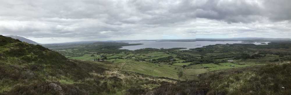
Once on the ridge proper the ground improves, and it leads you in an arc to the summit of Farbreiga. The views over Lough Con and Lough Cuillin are superb, as they are back towards Croagmoyle, Nephin etc. We descended a short distance north and then directly east, towards the Foxford Way.

I think of this two routes the ridge is the better option, as there appears to be far more hidden briars and holes on the ground to the east of the summit. Again, there was a very strong smell of Bog Myrtle in the air here, just the thing to keep the midges at bay! Once back on the Foxford Way, we retraced our route to our car Linkback: mountainviews.ie/summit/847/comment/5943/
Read Less
Read More

            MountainViews.ie picture about Farbreiga (<em>Fear Bréige</em>)
Picture: Castlebar 4 days walks ramble to Farbreiga
josvanderlinden on Farbreiga
by josvanderlinden 11 Jul 2009
Saturday 4th of July, today one of the Castlebar 4 days walks leads us to the Farbreiga mountain. For the first time the organisation of the walk included this mountain in one of their rambles. The weather is great and from above the group of walkers must look like a colony of ants on that hill. Linkback: mountainviews.ie/summit/847/comment/3922/
Read Less
Read More
EDIT Point of Interest
text
Videos

Users Online

Guests online: 377
Recent Contributions
x
Conditions and Info
Use of MountainViews is governed by conditions and a privacy policy.
Read general information about the site.
Opinions in material here are not necessarily endorsed by MountainViews.
Hillwalking is a risk sport. Information in comments, walks, shared GPS tracks or about starting places may not be accurate for example as regards safety or access permission. You are responsible for your safety and your permission to walk.
See the credits and list definitions.

OSi logo
OSNI/LPS logo
Open Street Map
(Various variations used.)
British summit data courtesy:
Database of British & Irish Hills