This website uses cookies, which are small text files that the website puts on your device to facilitate operation. Cookies help us provide a better service to you. They are used to track general user traffic information and to help the website function properly.
Short or GPS IDs, 6 char: Cummer, 10 char: Cummer Linkback: https://mountainviews.ie/summit/805/
Gallery for Cummer and surrounds
Summary
for Cummer :
Flattish heathery summit with some views.
Summary created by simon3
2011-10-18 08:53:20
One way of reaching this summit is from the south starting on the R497 at A (R9132 6123). Walk straight up the tarmac road heading NE until a gate which is at around 325m which is above most cultivation. Although the OSi map shows a track invitingly leading towards a forest and forest edge road, don't take this unless you are wearing wellies. Instead head directly towards higher ground and eventually to the summit. As of 2011 there is a high mast to the right near Reisk on the map which could well be a test for a future windfarm.
The unmarked top is flat and not very exciting though its position is good for views of much of the Shannons such as Mauherslieve, Keeper Hill, the Silvermines and the eastern Shannons Benduff-Devilsbit ridge.
I climbed Cummer using the the roadway shown on the OS map. This leads up past 3 recently built bungalows. Straight ahead is a hill with a large mast. This is the neighbouring hill of Reisk. Head up the laneway towards Reisk. The track swings sharp left and gets narrower and muckier. As Simon3 says wellies would be useful. The track enters the forest by a broken down gate. Keep right here and follow the edge of the forest up to the top of the ridge and then left to the flattish unmarked summit. The views in all directions are excellent. Lough Derg was visible to the north. Allow 1 hour for the return trip. Linkback: mountainviews.ie/summit/805/comment/6597/
Read Less
Read More
Rough ground but great views
by Arcticaurora
6 Apr 2024
Tried to follow what JohnRea did but we entered too deep into the forest, which became quite difficult to crawl through towards the top. At the top we saw a path going east and followed it to the open field for a while before reentering the forest for an easy track down. The track/lane back to the cars is rough so we parked at the last house on the lane up.
It would have been much easier to enter the east side of the forest and walk up as far as it reasily possible, go right into the field once the forest become too dense with low branches, and pick up the track in that field which brings you close to the top. You need to cross a wire fence and go west near the top. Linkback: mountainviews.ie/summit/805/comment/24172/
Read Less
Read More
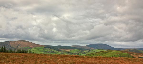
Picture: North west view from Cummer.
Photo from the top.
by simon3
18 Oct 2011
View from the top of Cummer. Mauherslieve on the left skyline, the dark rounded dome to the right skyline is Keeper Hill with some of the Silvermines ridge to the right edge of the picture.
The rough grass covers the top. Menacing clouds courtesy of October and a grad ND filter. Linkback: mountainviews.ie/summit/805/comment/6589/
Read Less
Read More
Easier route in 2022
by JohnRea
2 May 2022
Update based on conditions experienced in 2022. You can drive up the lane and there is space for one or two cars at Cumr S (R91728 61731). There is also plenty of parking space at B (R91477 61946) if you are willing to drive a very narrow boreen with some briar contact. The roadway between Cumr S (R91728 61731) and B (R91477 61946) was in good condition albeit with grass in the middle.
On the accent I walked diagonally from Cumr S (R91728 61731) to C (R91746 62495) and even with the aid of poles I found the ground conditions very heavy going with high grass, heather, lots of grass mounds, a few gullies and some deep water pools. After arriving at the top with one boot full of bog water I opted to descend through the mature forest keeping in one or two rows of trees from the eastern side of the trees. This turned out to be a very pleasant decent and there is evidence of others taking this route through the mature trees. A much safer route even for experienced ankles while the trees are mature. Linkback: mountainviews.ie/summit/805/comment/23507/
Use of MountainViews is governed by conditions and a privacy policy.
Read general information about the site. Opinions in material here are not necessarily endorsed by MountainViews.
Hillwalking is a risk sport. Information in comments, walks, shared GPS tracks or about starting places may
not be accurate for example as regards safety or access permission. You are responsible for your safety and your permission to walk.
See the credits and list definitions.


 Our Facebook page.