This website uses cookies, which are small text files that the website puts on your device to facilitate operation. Cookies help us provide a better service to you. They are used to track general user traffic information and to help the website function properly.
MountainViews is standardising on this new presentation style for the "Main Page". For a short while it is still possible to
Get the equivalent "old" page here. Or choose from the "Home" menu option above to change.
Feature count in area: 11, all in Cork,
OSI/LPS Maps: 79, 80
Highest Place: Musheramore 642.7m
Starting Places (8) in area Boggeragh Mountains: Butter Road, Duhallow Way, Derry Wood, Glannaharee East Woods S, Laharan Woods N, Millstreet Country Park, Mount Hillary Wood N, Mount Hillary Wood W, St John's Well
Summits & other features in area Boggeragh Mountains: Cen: Seefin: Knockcraugh 434m, Seefin 491m, Seefin East Top 491m N: Banteer: Mount Hillary 391m, Tooreen 322m NE: Bweeng: Bweeng Little 414m, Bweengduff 416m S: Macroom Hills: Burren 380m, Knockagreenan 263m W: Musheramore: Musherabeg 498.8m, Musheramore 642.7m
Note: this list of places may include island features such as summits, but not
islands as such.
Bweeng Little, 414mHill
Place Rating ..
For origin of name, see Bweeng Little., Cork County in Munster province, in no lists, Bweeng Little is the 883rd highest place in Ireland. Bweeng Little is the second most easterly summit in the Boggeragh Mountains area.
Grid Reference W46512 90892,
Mapsheet(s): 80 Place visited by: 33members, recently by: Padraigin, daitho9, DeirdreM, Pepe, maryblewitt, John.geary, chelman7, tommccarthy, Wildrover, magnumpig, ciarraioch, caiomhin, Juanita, Daingean, CaminoPat
I visited this place: NO (You need to be a logged-in member for this.)
Short or GPS IDs, 6 char: BwngLt, 10 char: BwngLtl Linkback: https://mountainviews.ie/summit/765/
Gallery for Bweeng Little and surrounds
Summary
for Bweeng Little :
Access on a forest track to a summit deep in the trees
Summary created by jackill
03 Aug, 2012
Park at a forest entrance GlHareeE WdN (W46444 88741), room for 5 cars. Follow the track into the forest , along the Duhallow way, taking the second left, then the first right, then second left then first right up to the buildings and masts. Follow the track around the back of the building to the trig pillar on top of Bweengduff. Follow the path downhil past the pillar, cross a track junction then go uphill on the farside into the forest, passing the first left to a "Y" junction. This is the summit area.
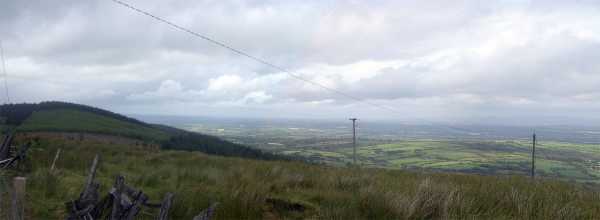
Picture: The wooded summit of Bweeng Little from Bweengduff
jackill on Bweeng Little
by jackill
27 Aug 2009
Once you've reached the trig on Bweengduff straight on down a bit then up a bit a rough track will bring you to the tree covered summit of Bweeg Little where there are really no views to speak of.
Again one for the hill-bagger Linkback: mountainviews.ie/summit/765/comment/4052/
Use of MountainViews is governed by conditions and a privacy policy.
Read general information about the site. Opinions in material here are not necessarily endorsed by MountainViews.
Hillwalking is a risk sport. Information in comments, walks, shared GPS tracks or about starting places may
not be accurate for example as regards safety or access permission. You are responsible for your safety and your permission to walk.
See the credits and list definitions.


 Add a Place Comment for Bweeng Little


 Our Facebook page.