This website uses cookies, which are small text files that the website puts on your device to facilitate operation. Cookies help us provide a better service to you. They are used to track general user traffic information and to help the website function properly.
Feature count in area: 30, all in Galway,
OSI/LPS Maps: 37, 38, 44, 45, EW-CON, MSW
Highest Place: Tully Mountain West 306m
Starting Places (66) in area Galway Coastal Hill: Angler's Return, Aughrusbeg Lough, Ballyconneely, Ben Lettery Hostel, Brandy Harbour, Bridge St Clifden, Bundouglas Bay, Bunnageeha, Cashel Church, Cleggan House, Cloonsie Quay, Cnoc Mordáin, Connemara National Park Visitor Centre, Coorhoor Lough North, Dernasliggaun, Dogs Bay Beach, Emlaghdauroe Bridge, Emlaghdauroe South, Eragh Island South, Fee Lough SW, Foher, Furnace, Fuschia Lane, Glencoaghan River Bridge, Glenmore, Gort Mór, Gortdrummagh West, Illaunroe North, Illaunroe South, Inaghbeg Path, Inchamakinna, Inishlay, Inishnee Bridge, Kilkieran South West, Lettercallow School Road, Letterfrack Lodge, Lettergesh Beach, unuseableLettermullen Pier, Loch Chamais, Lough Anivan Bend, Lough Auna S, Lough Fee East, Lough Nafiddaun South, Lough Natawny, Lough Tanny, Mace Head, Muck Lough NW, Mweenish Cemetary, Nacreeva Lough, Nambrackkeagh Lough, Omey Strand, Owen na Baunoge River, Owengar Bridge, Ros an Mhíl, Ross Beach, Ross Point, Ross Quay, Roundstone, Skeaghatimull, Sky Road, The Big Ring, Tievegarriff, Toombeola Bridge, Water Reservoir, Water Tank, Water Tank Carna
Summits & other features in area Galway Coastal Hill: Ardagh 49m, Ardbear N 64m, Ballynew 84m, Barraderry 68m, Camus Eighter 72m, Camus Hill 96m, Cleggan Beacon 61m, Cuilleen 97m, Dawros More North 41m, Derryadd West 127m, Derrygimlagh West 41m, Derrylahan 49m, Doon Hill 67m, Faul 50m, Foher 223m, Gortmore 122m, Kilkieran 165m, Kinvarra 67m, Knockfin 49m, Lehid 53m, Lettercallow 109m, Mannin Beg 41m, Maum 62m, Murneen 73m, Murvey 81m, Rossaveel 48m, Shanboolard 85m, Streamstown East 79m, Streamstown West 103m, Tully Mountain West 306m
Note: this list of places may include island features such as summits, but not
islands as such.
Cuilleen, 97mCoastal Hill An Coillín A name in Irish,
Place Rating ..
Cuilleen is the townland name., Galway County in Connacht province, in no lists Grid Reference L76441 32685,
OS 1:50k mapsheet 44 Place visited by: 7members, recently by: Fergalh, Caithniadh, markmjcampion, conormcbandon, aifric_n04, sandman, peter1
I visited this place: NO (You need to be a logged-in member for this.)
Overlooking the village of Carna access is via the tarred road leading to the Galway Council water tanks located at Watr Crna (L77113 32604) which are visible from the village. At the end of the surfaced road follow mucky tractor tracks seemingly heading towards the coast and before they start to descend head towards the summit. Linkback: mountainviews.ie/summit/5028/comment/19539/
Read Less
Read More
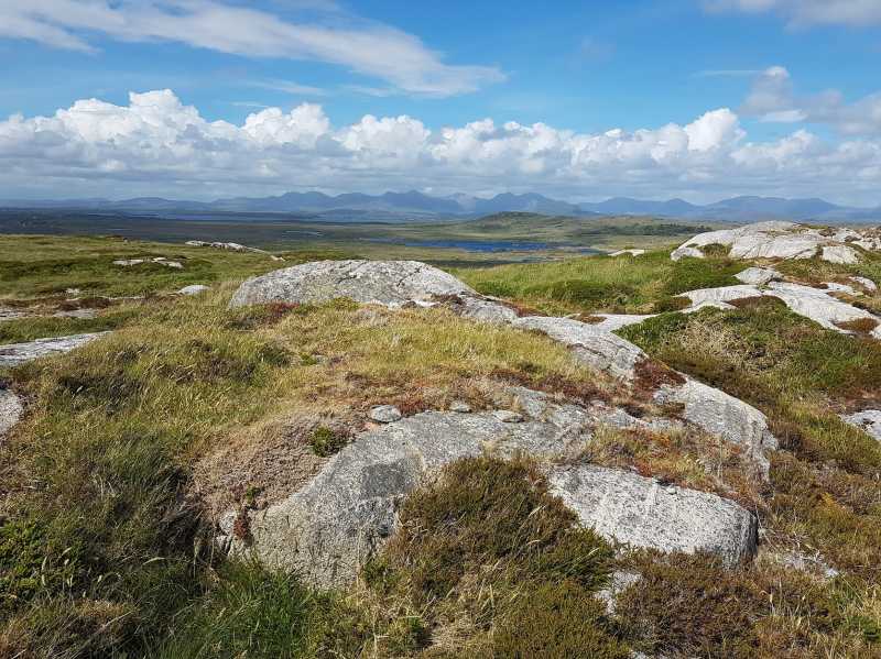
Picture: High up on the northern slopes!
Island view
by markmjcampion
5 Apr 2021
Headed up from the gravel pits at A (L77232 32992) and came down via Sandman's route for a short loop of about 30 mins. The going is easier via Sandman's route but any discomfort due to tussocky grass was short-lived. Great views of some of the inshore islands and bright white beaches. Linkback: mountainviews.ie/summit/5028/comment/22794/
Use of MountainViews is governed by conditions and a privacy policy.
Read general information about the site. Opinions in material here are not necessarily endorsed by MountainViews.
Hillwalking is a risk sport. Information in comments, walks, shared GPS tracks or about starting places may
not be accurate for example as regards safety or access permission. You are responsible for your safety and your permission to walk.
See the credits and list definitions.


 Add a Place Comment for Cuilleen, An Coillín


 Our Facebook page.