This website uses cookies, which are small text files that the website puts on your device to facilitate operation. Cookies help us provide a better service to you. They are used to track general user traffic information and to help the website function properly.
Feature count in area: 57, by county: Cork: 32, Kerry: 36, of which 11 are in both Cork and Kerry,
OSI/LPS Maps: 83, 84, 85, 88
Highest Place: Hungry Hill 682m
Starting Places (51) in area Caha Mountains: Ardgroom, Barley Lake North, Bere Island Pier, Caha Pass, Canshanavoe South, Carriganine, Cashelkeelty Stone Circles Carpark, Castletownbere Lifeboat Harbour, Clashduff River Farm, Coolieragh Harbour Road, Coomadayallig Lake Road N, Coomadayallig Lake Road S, Cooryeen Lane, Cummer Lough East Road, Derreenataggart Stone Circle Road, Dromoghty Lough North, Dunboy Wood, Esk Boreen, Eyeries, Fehanah Lane, Garinish Island Pier, Glantrasna Bridge, Glenbeg Lough N, Glengarriff, Glengarriff Nature Reserve CP, Gleninchaquin Waterfall, Gowlaun Lough, Healy Pass, Healy Pass Hairpin, Ilnacullin Car Park, Kenmare Bridge, Knockacullin Lane, Leahill Bog, Leitrim Beg Standing Stone, Lough Inchiquin SE, Magannagan Stream, Molly Gallivan's Visitor Centre, Nora's Cottage, Old Lansdowne School, Owgarriff River Lane, Peg's Shop, Pooleen Wood Car Park, Red Trout Lake, Reenroe Bridge, River Drimminboy Track, Rossmackowen Bridge, Rossmackowen Cemetery, Shronebirrane Farm, Shronebirrane Road, Toberbanaha, Turner's Rock Tunnel
Summits & other features in area Caha Mountains: Cen: Hungry Hill: Coombane 510m, Derryclancy 554m, Hungry Hill 682m Cen: Knockowen: Cushnaficulla 594m, Glenkeel Top 417m, Knockastumpa 398m, Knockeirky 577m, Knockeirky South Top 523m, Knockowen 658m, Stookeennalackareha 412m E: Glengarriff: Derrynafulla SW 375m, Gowlbeg Mountain 362m, Nareera 530m, Nareera North Top 503m, Nareera South-West Top 505m, Shrone Hill 283m, Sugarloaf Mountain 574m, Sugarloaf Mountain Far West Top 560m, Sugarloaf Mountain West Top 565m N: Coomnadiha: Baurearagh Mountain 489m, Caha Far SE Top 555m, Caha SE Top 585m, Coomnadiha 644m, Coomnalack Top 435m, Cummeenbaun 510m, Droppa 522m, Killane Mountain 537m, Killane Mountain South-West Top 533m, Knockagarrane 414m, Knockreagh 500m N: Knockeirka: Barraduff Mountain 400m, Killaha Mountain 400m, Knockeirka 426m N: Knocknagorraveela: Derrysallagh 410m, Feorus East 474m, Knocknagorraveela 507m, Knocknagorraveela NE Top 464m N: Lauragh: Knockanoughanish 386m, Knockatee 330m S: Castletownbere: Disert 205m, Knockanallig (Bear Island) 267m W: Ardgroom: Derryvour Hill 160m W: Eskatarriff: Coomacloghane 599m, Eskatarriff 600.5m, Eskatarriff East Top 532.7m, Knocknaveacal North Top 509.1m, Knocknaveacal South Top 507.2m, Lackabane 603m, Tooreenbaha 408.7m, Tooreennamna 524m, Tooth Mountain 592m W: Knocknagree: Knocknagree 586m, Knocknagree East Top 461m, Knocknagree SE Top 442m, Lackawee 572m, Maulin 621m, Maulin North Top 579m
Note: this list of places may include island features such as summits, but not
islands as such.
Killane Mountain, 537mMountain Sliabh Uí Choileáin A name in Irish,
Place Rating ..
prob. Ir. Sliabh Uí Choileáin [logainm.ie‡], 'Ó Coileáin’s mountain', Cork/ Kerry County in Munster province, in Arderin Lists, Killane Mountain is the 455th highest place in Ireland.
Grid Reference V87290 59559,
OS 1:50k mapsheet 85 Place visited by: 76members, recently by: bandre, maoris, Krzysztof_K, miriam, Wilderness, Geo, mountainmike, JohnRea, jackos, chelman7, annem, gernee, eoghancarton, No1Grumbler, tfm9
I visited this place: NO (You need to be a logged-in member for this.)
Longitude: -9.633766, Latitude: 51.77755, Easting: 87290, Northing: 59559,
Prominence: 82m, Isolation: 0.7km ITM: 487264 559624 Bedrock type: Purple & green sandstone & siltstone, (Caha Mountain Formation) Notes on name: Killane Mountain is notable for its narrow ridge, with particularly steep slopes to the NW dropping into the Baurearagh valley. It forms the narrowest, steepest section in the chain of peaks connecting Caha with Turner’s Rock and on towards Knockboy. The Irish name provided here is inferred from Coorakillane / Cuar Uí Choileáin, a townland in the parish of Kilcaskan on the SE slopes of Killane Mountain.
Short or GPS IDs, 6 char: KlnMnt, 10 char: KlnMntn Linkback: https://mountainviews.ie/summit/379/
Gallery for Killane Mountain (Sliabh Uí Choileáin) and surrounds
Summary
for Killane Mountain (Sliabh Uí Choileáin):
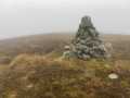
Heading for the narrows
Summary created by jackill
2010-10-31 10:05:18
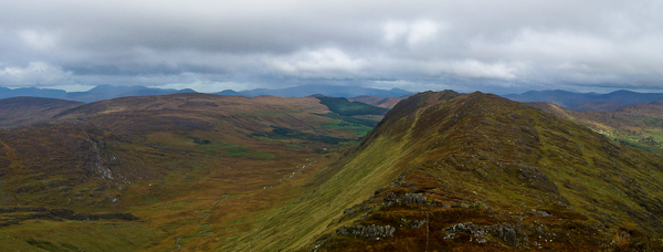
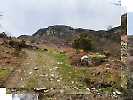
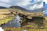
Picture: From Rams Hill looking towards Killane
Park on the Kerry side of the tunnel at about Caha Pass (V901 605) where there is room for a few cars on the roadside.
Walk down the road towards kerry looking for a grassy ramp on your left
Go up the grassy ramp to gain the ridge.
Head west along the ridge to the summit area of Baurearagh Mountain crossing 3 fences on the way.
Drop down after Baurearagh Mountain and a short climb passing some large exposed rock sheets will bring you to the summit area.
If you intend to carry on after this towards the Caha plateau please note that the ridge narrows significantly after this , care is needed as the cliffs to the north are quite steep.
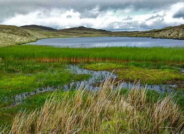
Killane was the fourth top in a long day's walking, which began with the Sugarloaf, Sugarloaf West Top, Nareera and then crossed the huge swathe of largely flat but fascinating landscape which is approximately 8 sq km and marked on the OS map by Glenlough Mt and Ram's Hill (which are not MV listed summits). the area is little visited one suspects as it holds no summits for bagging, nevertheless it is worth the excursion. It is a mixture of small rises, boulders, marsh, rocky ridges and countless small loughs. Unfortunately on the day we made the south north traverse the weather turned nasty and denied us much of the view, but not before we encountered such gems as the small reedy lough seen in the accompanying pic, which was immediately to the west of Ram's Hill, about 3km to the SW of Killane Mountain. Linkback: mountainviews.ie/summit/379/comment/6353/
Read Less
Read More
simon3 on Killane Mountain
by simon3
28 Apr 2003
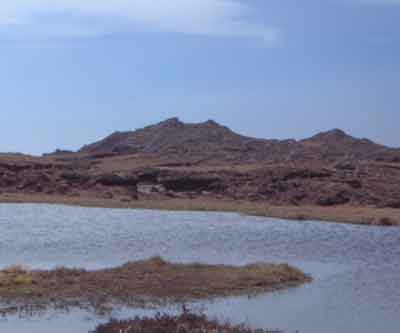
This view from Killane south includes three mountains in a group of similar height just left of centre. The leftmost of these is Sugarloaf, which from this angle doesn’t look at all like the sharp ridge it appears as from Glengarriff. The two to the right of it are Toberavanaha and Nareeva, less travelled mountains both of over 500m. Linkback: mountainviews.ie/summit/379/comment/454/
Read Less
Read More
simon3 on Killane Mountain
by simon3
28 Apr 2003
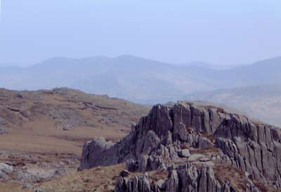
Killane Mountain, a long whaleback of a summit, possesses this fine top which looks like a pair of devil’s horns from some angles. Linkback: mountainviews.ie/summit/379/comment/453/
Read Less
Read More
TrebleRed on Killane Mountain
by TrebleRed
2 Feb 2006
A very nice walk, incorporating this mountain and two others. 12 of us walked it on Sunday, starting from the carpark in the Nature Reserve. Walked about 40 min on roads until first tunnel and went off road at that point. Beautiful views the whole way round, our descent from Eagles Nest was a little hairy in one spot but otherwise a near perfect day. Well worth looking into. A six hour walk. Linkback: mountainviews.ie/summit/379/comment/2165/
Use of MountainViews is governed by conditions and a privacy policy.
Read general information about the site. Opinions in material here are not necessarily endorsed by MountainViews.
Hillwalking is a risk sport. Information in comments, walks, shared GPS tracks or about starting places may
not be accurate for example as regards safety or access permission. You are responsible for your safety and your permission to walk.
See the credits and list definitions.


 Our Facebook page.