This website uses cookies, which are small text files that the website puts on your device to facilitate operation. Cookies help us provide a better service to you. They are used to track general user traffic information and to help the website function properly.
Feature count in area: 9, by county: Clare: 8, Galway: 1,
OSI/LPS Maps: 52, 58
Highest Place: Moylussa 531.6m
Starting Places (6) in area East Clare: Ballycuggeran Forest, Clarisford Park, Crag Bridge CP, Glenagalliagh, Glenwanish, Two Mile Gate CP
Summits & other features in area East Clare: Cen: Slieve Bernagh: Ballykildea Mountain 412m, Cragnamurragh 526m, Glennagalliagh Mountain 446m, Moylussa 531.6m N: Slieve Aughty: Cappaghabaun Mountain East 378m, Cashlaundrumlahan 358m, Maghera 400m S: Sixmilebridge: Knockanuarha 309m, Woodcock Hill 310m
Note: this list of places may include island features such as summits, but not
islands as such.
Woodcock Hill, 310mHill Cnoc na gCreabhar A name in Irish,
Place Rating ..
(Ir. Cnoc na gCreabhar [logainm.ie], 'hill of the woodcocks'), Clare County in Munster province, in Binnion Lists, Woodcock Hill is the 1143th highest place in Ireland. Woodcock Hill is the most southerly summit and also the second most westerly in the East Clare area.
Grid Reference R52263 63439,
OS 1:50k mapsheet 58 Place visited by: 89members, recently by: BarnabyNutt, Tuigamala, finkey86, DeirdreM, Jai-mckinney, johncusack, CusackCharlie, CusackMargaret, rquirke27, dregish, Oscar-mckinney, Carolyn105, ciarraioch, Krzysztof_K, GerSomers
I visited this place: NO (You need to be a logged-in member for this.)
Longitude: -8.707214, Latitude: 52.720328, Easting: 152263, Northing: 163439,
Prominence: 265m, Isolation: 6.5km, Has trig pillar
ITM: 552222 663481 Bedrock type: Red conglomerate, sandstone & mudstone, (Old Red Sandstone (undifferentiated)) Notes on name: This hill is named in the Yellow Book of Lecan as: a mullach Slebe Shuidi in Rig ('mountain of the king's seat') and in the Book of Lismore as: Sliabh Uighi in Rig ('mountain of the king's grave') .
Short or GPS IDs, 6 char: WdccHl, 10 char: WdcckHil Linkback: https://mountainviews.ie/summit/948/
Gallery for Woodcock Hill (Cnoc na gCreabhar) and surrounds
Summary
for Woodcock Hill (Cnoc na gCreabhar):
Domes and dumps
Summary created by jackill
2010-10-23 07:43:39
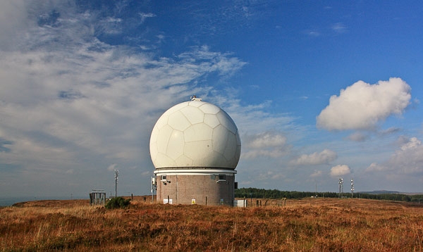
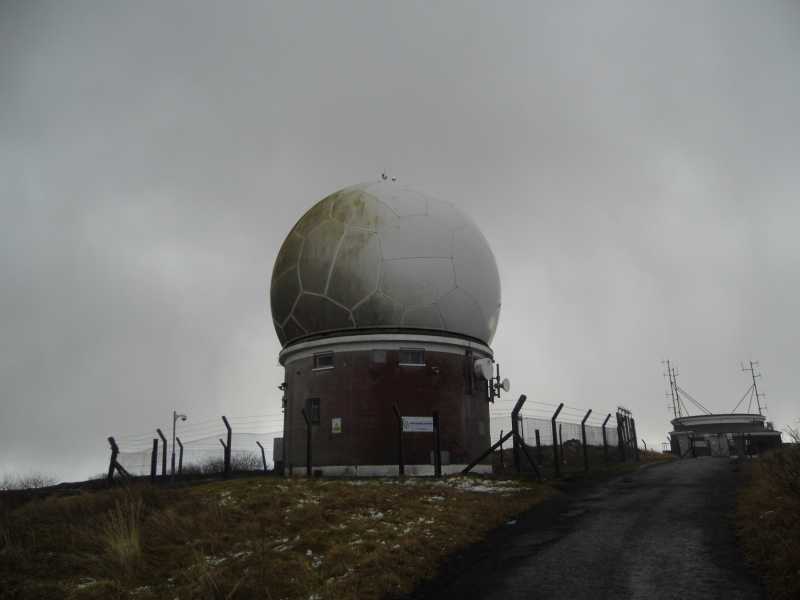
Park at A (R519 638), room for 1or 2 cars. Follow the single track access road over a small bridge and past a fly tipping area. The Irish Aviation Authority has a radar unit on the top which includes two white dome-shaped structures, the summit trig pillar is behind these.
We (some long suffering family members) went through the tunnel heading for Galway having left the lovely City of Limerick behind us. Headed for Cratloe where we took the second left thus following the sign for Cratloe Woods. We then came across a split in the road. This is where we took the ‘middle’ road where a Clare County Council have a ‘No Dumping’ sign. We parked at a forestry entrance named ‘Gallows Hill’. We set off for Woodcock Hill following the directions in the first comment box on Mountain Views! Onwards and gently upwards until the ‘Ball’ came into sight. Then we turned off the road on to the service road and crossed a little bridge. The views getting better and better. When we reached the trig point we were all in awe at the wonderful panoramic views. The mighty Shannon river flowing to its wide estuary. The ‘low’ hills of Kerry and Clare marked its boundaries. While below Limerick City clear and close. Thomond Park a distinctive give away that this was the Treaty City below, Keeper, the Arra Mountains and way in the distance Benduff in the Devils Bit range, the Galty’s, Ballyhoura and Slieve Felims all to be seen. I saw no woodcocks but could imagine this 1023ft mountain was the seat of a King of old as the Gaelic name hints at. A vantage point too good not to have been, the ‘Golf Ball’ marks the spot, well worth a visit of a sunny day. Linkback: mountainviews.ie/summit/948/comment/6066/
Read Less
Read More
Picture: Are "they" watching us!!
osullivanm on Woodcock Hill
by osullivanm
25 Oct 2009
Having driven from Dublin to Killaloe, we were looking for a relaxing, undemanding walk which would, hopefully, provide good views of the surrounding countryside. Our eyes were drawn to Woodcock Hill - a relatively isolated hill, standing at 310m and accessible by road, - it looked as though it would fit the bill. We parked at A (R519 638) to walk the final few hundred metres to the top. The Irish Aviation Authority has a radar unit on the top which includes two rather interesting looking white dome-shaped structures. As anticipated, we enjoyed a panoramic view of the area including parts of the Shannon and Limerick City. We met a number of other walkers and formed the impression that this is an excellent spot for a relaxing weekend stroll!. Linkback: mountainviews.ie/summit/948/comment/4226/
Read Less
Read More
Picture: So this is what the giant golf ball was!
Giant golf ball
by TommyV
25 Oct 2018
There is a road heading north out of the village of Cratloe out past the enterence to Cratloe Woods. After about 5 kilometers along this road at B (R51945 63870) there is room to park. You will see an odd looking structure built by the Irish Aviation Authority less than 500 meters away from the road. When I was younger, driving to Limerick with my parents, this always looked like a giant golf ball on a hill, well to a young mind it did. The trig point is only another 50 meters behind this structure. From here you can see out to the Shannon estuary and also Thomond Park in all it's glory. Linkback: mountainviews.ie/summit/948/comment/20097/
Use of MountainViews is governed by conditions and a privacy policy.
Read general information about the site. Opinions in material here are not necessarily endorsed by MountainViews.
Hillwalking is a risk sport. Information in comments, walks, shared GPS tracks or about starting places may
not be accurate for example as regards safety or access permission. You are responsible for your safety and your permission to walk.
See the credits and list definitions.


 Our Facebook page.