Cookies.
This website uses cookies, which are small text files that the website puts on your device to facilitate operation. Cookies help us provide a better service to you. They are used to track general user traffic information and to help the website function properly.
Features
Nearby features appear when you click the map.
Declutter tracks on map.
Place Search
Video
X
Pub: by
Achill & Corraun Area , SE: Corraun Subarea
Feature count in area: 16, all in Mayo, OSI/LPS Maps: 22, 30, CBW, EW-ACC, EW-ACC
Highest Place: Croaghaun 688m

Starting Places (16) in area Achill & Corraun:
Achillbeg Island, Achillbeg Mid West Beach, Barneygappul Strand, Belfarsad Bridge, Breanaskill, Bunanioo Church, Cartron River, Clare Island, Doogort Beach, Fiodián na Circe, Keem Bay, Lough Acorrymore, Lough Gall, Minaun Mast, Rossnafinna Island, Tobercolman Cross Cemetery

Summits & other features in area Achill & Corraun:
Cen: Minaun: Minaun (Achill Island) 466m
N: Slievemore: Krinnuck (Achill Island) 214m, Slievemore (Achill Island) 671m
NW: Croaghaun: Benmore (Achill Island) 332m, Cornaclea Hill (Achill Island) 269m, Croaghaun (Achill Island) 688m, Croaghaun SW Top (Achill Island) 664m
S: Knockmore Achill: Achillbeg Island N Top (Achillbeg Island) 109.7m, Achillbeg Island S Top (Achillbeg Island) 108.5m, Knockmore (Achill Island) 337m, Tievereivagh (Achill Island) 286m
SE: Corraun: Knocklettragh 452m, Corraun Hill 524m, Corraun Hill Highpoint 541m
SW: Clare Island: Knockmore (Clare Island) 462m, Knocknaveen (Clare Island) 223m

Note: this list of places may include island features such as summits, but not islands as such.
Rating graphic.
Knocklettragh, 452m Hill Cnoc Leitreach A name in Irish,
Place Rating ..
Ir. Cnoc Leitreach [LME], 'hill of the wet hillside’ Owenduff an extra name in English, Mayo County in Connacht province, in Carn Lists, Cnoc Leitreach is the 729th highest place in Ireland. Cnoc Leitreach is the most easterly summit in the Achill & Corraun area.
Grid Reference F78220 00458, OS 1:50k mapsheet 30
Place visited by: 19 members, recently by: poopoobasto, IncaHoots, Geo, Marty08, conormcbandon, Fergalh, markmjcampion, PaulNolan, MichaelE, jimbloomer, Oileanach, chalky, garrettd, eamonoc, turfymccloud
I visited this place: NO (You need to be a logged-in member for this.)
Longitude: -9.855174, Latitude: 53.939208, Easting: 78220, Northing: 300458, Prominence: 309m,  Isolation: 4.4km
ITM: 478196 800469
Bedrock type: Quartzites, schists, chloritic metatuffs, (Ashleam Head Formation)
Notes on name: This peak is unnamed on OS maps. On William Bald's map of Co. Mayo (1830) it is named Knockletragh. This name is confirmed by Fiachra Mac Gabhann in Logainmneacha Mhaigh Eo. Previously Owenduff Hill in MV.
  Short or GPS IDs, 6 char: Kncklt, 10 char: Knckltrgh

Linkback: https://mountainviews.ie/summit/614/
Gallery for Knocklettragh (Cnoc Leitreach) and surrounds
No summary yet for this place .
Member Comments for Knocklettragh (Cnoc Leitreach)
Comment create / edit display placeholder

New Knockletragh from North - school report
by rhw 5 May 2024
From N, Tonragee school, good track, runs out pretty soon (L branch, parking available just before junction); NE ridge works well, decent terrain, trail shoes stayed +/- dry Linkback: mountainviews.ie/summit/614/comment/24192/
Read Less
Read More

            MountainViews.ie picture about Knocklettragh (<em>Cnoc Leitreach</em>)
Picture: Achill from Knocklettragh
17 hours, 3 summits, and legions of midges
by Geo 12 Jul 2022
Using info gleaned here I used track 4024 as a template for my walk.
I started on Sunday evening, warm and muggy, climbing Knocklettragh from the busy road to the East.
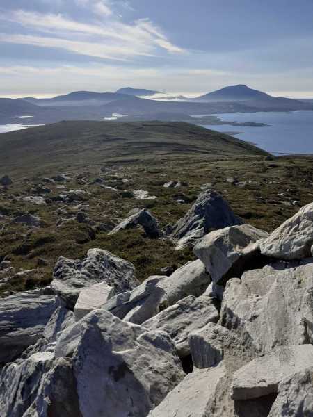
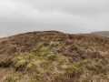
From the summit of this lovely hill, I couldn't believe I was only the 17th MV member to tick this off.
I had a hydration break, a snack, took some photos and then continued west and south around to the bog workings west of the extensive Coillte forestry.
The issue then became one of excessive numbers of tiny biting, flying things, as I was now out of the breeze, and as it approached dusk, the little blighters rose from the corrie bogs and attacked me, the sole human who made the mistake of being there at that time. Mosigard gave only very short respite, as I made camp in record time diving in to my tent and zipping out the flysheet, not before several hundred got in anyway, attached as they were to various bits of me.
After a fitful night's sleep, broken by the bleating of lambs on the hills and some sort of imagined jabberwocky snuffling about outside I was glad the morning came with a stiff breeze to keep little creatures in their hiding places.
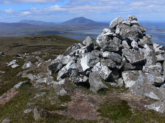
Breakfast of boiled eggs, rice cake, maple pecan, banana and a half litre of coffee I could have walked across, I shouldered my heavy pack and slowly wended my way up the spur to make the trig on Corraun Hill in time for a ten o'clock hydration break ( with some lovely sour squirms).
Then, striking while the iron was hot, I head over to the east top.
I took the spur to the west of corrie lea, carefully descending its steep sides, happy that the recent dry weather meant I could keep my balance and footing until I reached the forest below, heading east along its boundary until I reached an easy forest ride, bringing me back to the forest Road, and hence to my car.
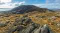
A tough but really rewarding walk, almost 20km long with 900m plus of ascent. I couldn't find a single human footprint the whole way, and didn't see another human for nearly 17 hours until I was on the final forest stretch where I met a few mountain bikers.
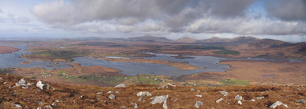
A walk to add to the bucket list if solitude and peace is what you seek, and that is without mentioning the stupendous views of a dozen or more of the surrounding mountain ranges. Linkback: mountainviews.ie/summit/614/comment/23581/
Read Less
Read More

            MountainViews.ie picture about Knocklettragh (<em>Cnoc Leitreach</em>)
Picture: North and East of Owenduff Hill
simon3 on Knocklettragh
by simon3 25 Mar 2008
Owenduff is like a giant comma, its head at the summit, its tail stretching and descending SW. Showing few signs of being visited it does however possess a large white cairn of the local quartzite stone.

One way of reaching the summit, via the tail, is as follows. Park at Gall L (L80296 99725) at a forestry entrance on the main road. (This is the same starting place as David Herman describes for a Corraun walk in Hill Walkers Connemara and Mayo.) Walk SW along the well made forestry road. When you reach another track leading NW ignore it. Continue W past a point where a waymarked way leaves the track. The track curves north at this point towards the tail of Owenduff. As of Mar 2008 it was possible to simply walk west across the recently cut forest to the forest edge starting from the track at A (L77546 98741). Climb onto the undulating tail and ascend Owenduff. There are some outcrops en-route. As you rise your view expands in all directions (a bit like the walk up Claggan). To the south are the corries of Corraun to the south west and west Achill. Further you can see some of the drowned drumlins of Clew bay. At the summit you can even see Croagh Patrick. Return by walking down the east side of Owenduff. This turned out to be difficult in wet conditions, though not taking so long. You can get to the road at B (F79978 00213) beside the bridge and then walk back to your transport.

The photo shows the intricate coastline leading to Bellacragher Bay on the right. The skyline is dominated by the Nephin Begs. Linkback: mountainviews.ie/summit/614/comment/3020/
Read Less
Read More

            MountainViews.ie picture about Knocklettragh (<em>Cnoc Leitreach</em>)
Picture: The principal heights of Achill from Knockletragh
A super and significant hill
by Harry Goodman 2 Jun 2010
Knockletragh is the hill that the R319 skirts around on the way to Achill from Mulranny (Mallarany). From this drive it does not look to be a hill of any consequence and at 452m is significantly lower than its near neighbour Corraun Hill. Don't be deceived, this is a worthwhile climb that would put many 500+ summits in the shade. We climbed it on Wed. 26 May 2010 by more or less following simon3's excellent route, with two little mistakes en route!! We parked at Gall L (L80296 99725) (as noted by simon3) and took the well made forestry road SW. Having gone through two gates, the second with a stile we came to a fork in the track 1.6k into the walk at C (L79129 98533) and forked right in the direction of Knockletragh content that it would lead us to simon3's next point A (L77546 98741) but no, first mistake, it led to a turning circle and end of the track in the midst of a large fell cleared area. Our second and thankfully last mistake was to take to the fell cleared area in search of A (L77546 98741) across very difficult terrain rather than retrace our steps. However by chance we picked up a rough machine made track which had flattened the timber debris and made the going much easier. When we reached simon3's checkpoint A (L77546 98741) it was frustrating to find that it lay on a very well constructed forest track which was in fact a continuation of the track we had taken at the start and would have followed if we had gone left instead of right when it had forked. We would then further along turned N to reach A (L77546 98741). At this point, back on course, we crossed the clear felled area to a fence at D (L77057 98855) where, thankfully, normal hillwalking terrain resumed. We then crossed the hillside W to pick up a stone track at E (L76719 98810) which led us on to the tail of the hill where we turned right to follow the ridge NE for some 3k to the summit. As we climbed the full vista of Achill lay before us to the W while S we had sight of the corrie bound ridge of Corraun Hill with it's many small loughs spread out below us. Near the top of the ridge we passed a couple of rocky up crops with magnificent views down to and across Achill Sound. The summit is crowned by a stone cairn and, unexpectedly, becomes a large flatish, stoney barren area before dropping NE down a steep spur to the R319 and a bridge at B (F79978 00213). Our going was over dry ground but as simon3 suggests this would be difficult when wet. From here it was a short walk along the road to the start point. A walk of 10k in just over three hours including our "off piste" sorties. Thank you simon3 for bringing this hill and a super walk to my attention. Linkback: mountainviews.ie/summit/614/comment/5851/
Read Less
Read More
EDIT Point of Interest
text
Videos


Users Online
DeirdreM, Dee68, ChrisC, maryblewitt, jgfitz
Guests online: 171
Recent Contributions
x
Conditions and Info
Use of MountainViews is governed by conditions and a privacy policy.
Read general information about the site.
Opinions in material here are not necessarily endorsed by MountainViews.
Hillwalking is a risk sport. Information in comments, walks, shared GPS tracks or about starting places may not be accurate for example as regards safety or access permission. You are responsible for your safety and your permission to walk.
See the credits and list definitions.

OSi logo
OSNI/LPS logo
Open Street Map
(Various variations used.)
British summit data courtesy:
Database of British & Irish Hills