Cookies.
This website uses cookies, which are small text files that the website puts on your device to facilitate operation. Cookies help us provide a better service to you. They are used to track general user traffic information and to help the website function properly.
Features
Nearby features appear when you click the map.
Declutter tracks on map.
Place Search
Video
X
Pub: by
Nephin Begs Area , Cen: Glennamong Subarea
Feature count in area: 28, all in Mayo, OSI/LPS Maps: 22, 23, 30, 31, CBW, EW-ACC, EW-WNN, EW-WNS
Highest Place: Slieve Carr 721m

Starting Places (24) in area Nephin Begs:
Altnabrocky Adirondack Shelter, Bellanaderg Bridge, Brogan Carroll Bothy, Bunnahowna Bridge, Bunnahowna River, Burrishoole Loop, Cloondaff Church, Deel River, Furnace Lough E, Glasheens River, Glendahurk Bridge, Glennamong Bridge, LFeeagh E Treenbeg Cottage, LFeeagh E Treenbeg School Ruin, Lough Avoher Hut, Lough Feeagh, Lough Gall NW Mayo, Loughanawillan Loughs Track, Mulranny Post Office, R312 Boghadoon, R312 Prughlish, Srahduggaun, Tarsaghaunmore River, Wild Nephin Wilderness

Summits & other features in area Nephin Begs:
Cen: Glennamong: Bengorm 582m, Bengorm NW Top 468m, Corranabinnia 716m, Corranabinnia SW Top 687m, Glennamong 628m, Glennamong East Top 415m, Tirkslieve 401m
Cen: Nephin Beg: Aroher Hill 285m, Lettertrask 279m, Nephin Beg 627m, Nephin Beg South Top 410m
E: Birreencorragh: Birreencorragh 698m, Birreencorragh South Top 564m, Birreencorragh West Top 551m, Buckoogh 588m, Bullaunmore 388m, Knockaffertagh 517m, Mount Eagle 427m, Srahmore 186m, Srahrevagh North 282m
NW: Slieve Carr: Bunmore 243m, Sheeanmore 282m, Slieve Alp 329m, Slieve Carr 721m, Tawnyanruddia 531m
SW: Maunthomas: Claggan Mountain NE Top 501m, Maumthomas NE Top 440m, Maumthomas SW Top 477m

Note: this list of places may include island features such as summits, but not islands as such.
Rating graphic.
Bengorm NW Top, 468m Hill An Bhinn Ghorm (mullach thiar thuaidh) A name in Irish,
Place Rating ..
For origin of name, see Bengorm., Maumahieran, Mayo County in Connacht province, in Carn Lists, Bengorm NW Top is the 670th highest place in Ireland.
Grid Reference F91941 02524, OS 1:50k mapsheet 30
Place visited by: 102 members, recently by: srr45, Carolyn105, abeach, ochils_trekker, tonio22, Krzysztof_K, Beti13, glencree, Solliden, annem, shnackbox, ryanguinness10, elizauna, pdtempan, philmchale
I visited this place: NO (You need to be a logged-in member for this.)
Longitude: -9.648411, Latitude: 53.961605, Easting: 91941, Northing: 302524, Prominence: 43m,  Isolation: 1.6km
ITM: 491828 802625
Bedrock type: Psammitic schists, quartzites, (Anaffrin Formation)

  Short or GPS IDs, 6 char: BngrNW, 10 char: BngrmNWTp

Linkback: https://mountainviews.ie/summit/556/
Gallery for Bengorm NW Top (An Bhinn Ghorm (mullach thiar thuaidh)) and surrounds
Summary for Bengorm NW Top (An Bhinn Ghorm (mullach thiar thuaidh)): Short Summary
Summary created by Peter Walker, Geo 2016-07-04 07:04:29
            MountainViews.ie picture about Bengorm NW Top (<em>An Bhinn Ghorm (mullach thiar thuaidh)</em>)
Picture: Bengorm NW Top (middle) from Corranbinnia
Bengorm NW Top is on the Glendahurk horseshoe. Easily crossed from Bengorm to Corranbinnia (or vice-versa). This starts at car park on boreen at Gl'dHurk Brg (L91061 97962). The summit itself is at A (F91984 02478).
Linkback: mountainviews.ie/summit/556/comment/5315/
Member Comments for Bengorm NW Top (An Bhinn Ghorm (mullach thiar thuaidh))
Comment create / edit display placeholder

Fantastic Four take Mayo by storm
by Geo 7 Aug 2011
A comment for an uncommented mountain.
Liz50, Muschi, Sandman and myself took ourselves across the country to do the Glendahurk Horseshoe. It rained as we crossed the midlands and got West of the Shannon, but cleared as we donned the boots in the little car park at Gl'dHurk Brg (L91061 97962)
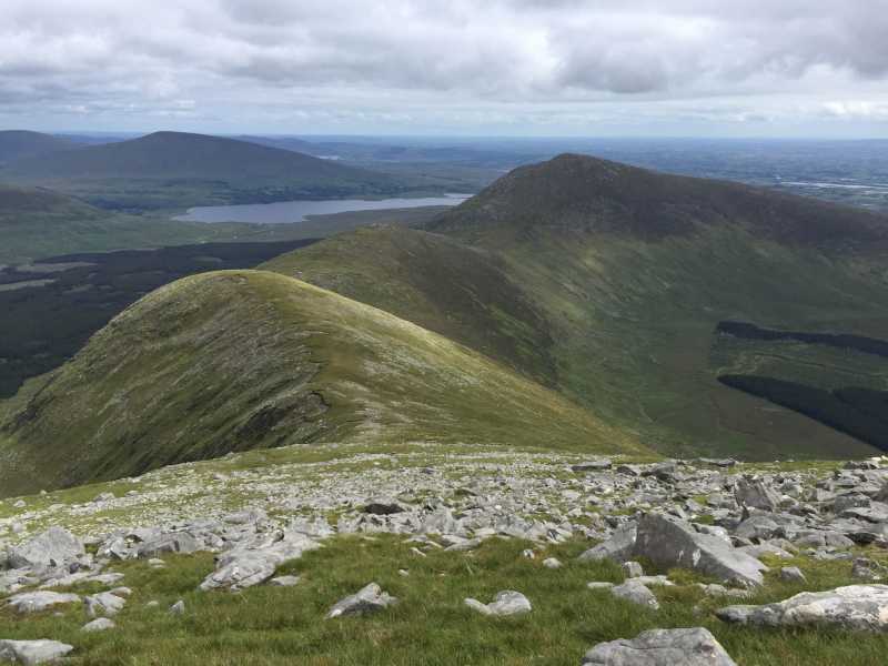
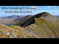
. I was very impressed with the signage for the local looped walks and the large OS based map in the car park. We head up the ridge walking North (doing the horseshoe clockwise). Only saw one car on our way but for the entire walk not another sinner, in fact finding another footprint was difficult, such was the beautiful emptiness of this fantastic big sky country. Clouds threatened from the Atlantic, and from time to time rain was seen over Achill, the Reek and the bog land north of us, but our ridge just kept on rising and the mist rose with it.
Lunch was had on Corranbinnia after a very cautious crossing of the arete from Corranbinnia SW, and had smashing views of Slieve Carr, bringing back recollections of an arduous walk last August when that dragon was slain!
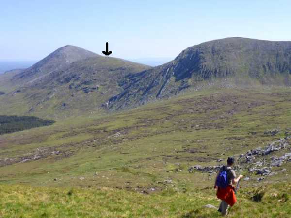
A careful descent to the little top between Corranbinnia and Bengorm NW, before continuing south to the summit of Bengorm NW itself. We had a bit of craic with agreeing to disagree over the particular rock which was the apex, my own GPS reading being A (F91984 02478), which wasn't allowed by MV as it was too far from the co-ordinates given(Simon please take note!).
Finally we did the last thigh wrenching drag up Bengorm and had a quick snack on a midge infested summit, before our return to the track 400m North of the car park, traversing a bog, which thankfully was quite dry.
As we removed the boots a shower fell, but I have to say, we were blessed with a brilliant day, for what is definitely one of Ireland's top ridge walks, up there with the best of them. a shade under 15km and with nearly 1100m climbing but well, well worth it. Linkback: mountainviews.ie/summit/556/comment/6467/
Read Less
Read More

            MountainViews.ie picture about Bengorm NW Top (<em>An Bhinn Ghorm (mullach thiar thuaidh)</em>)
Picture: Bengorm NW Top as seen from the shoulder of Glennamong
A little gem
by Colin Murphy 28 May 2012
Overshadowed by its bigger brother, but a small gem in its own right, Bengorm NW is steeply sided with a rocky summit, marked by several boulders. It is difficult to be precise about the highest point, but it is likely to be found towards the SE end of the summit area, marked by a large boulder. Linkback: mountainviews.ie/summit/556/comment/6827/
Read Less
Read More
EDIT Point of Interest
text
Videos


Recent Contributions
x
Conditions and Info
Use of MountainViews is governed by conditions and a privacy policy.
Read general information about the site.
Opinions in material here are not necessarily endorsed by MountainViews.
Hillwalking is a risk sport. Information in comments, walks, shared GPS tracks or about starting places may not be accurate for example as regards safety or access permission. You are responsible for your safety and your permission to walk.
See the credits and list definitions.

OSi logo
OSNI/LPS logo
Open Street Map
(Various variations used.)
British summit data courtesy:
Database of British & Irish Hills