This website uses cookies, which are small text files that the website puts on your device to facilitate operation. Cookies help us provide a better service to you. They are used to track general user traffic information and to help the website function properly.
Feature count in area: 58, all in Down,
OSI/LPS Maps: 20, 29, EW-CLY
Highest Place: Slieve Donard 849m
Starting Places (33) in area Mourne Mountains: Alex Steddom Tree, Aughrim Airstrip, Ben Crom Dam, Bloody Bridge Car Park, Carlingford Greenway, Carrick Little, Crocknafeola Wood, Crotlieve Mountain, Donard Car Park Newcastle, Drummanmore Picnic, Fofanny Reservoir, Forest Office CP, Gamekeepers Lodge CP, Happy Valley Trassey Rd, Hen Mountain CP, Leitrim Lodge CP, Mayo Road Corner, Meelmore Lodge, Newcastle Harbour, Ott CP, Red Bog Road, Rourkes Park, Sandy Brae, Silent Valley Reservoir Head Rd, Slieve Donard Trail Head, Slieve Foye Viewing Point, Slievefoy Forest CP, Spelga Dam E, Spelga Dam N, Spelga Dam S, Trassey Car Park, Two Mile River CP, Yellow Water Park
Summits & other features in area Mourne Mountains: Cen: Loughshannagh: Ben Crom 526m, Carn Mountain 585.2m, Carn Mountain North Top 553.7m, Doan 592.6m, Ott Mountain 526.8m, Slieve Loughshannagh 617m, Slieve Muck 670.4m, Slievenaglogh 445m E: Binnian: Slieve Binnian 745.9m, Slieve Binnian East Top 639m, Slieve Binnian North Top 678m, Slieve Binnian North Tor 682.5m, Wee Binnian 460m E: Donard: Chimney Rock Mountain 656m, Crossone 540m, Millstone Mountain 460m, Rocky Mountain 524m, Slieve Donard 849m E: Lamagan: Cove Mountain 654.8m, Slieve Beg 595.9m, Slievelamagan 702.2m N: Bearnagh: Slieve Bearnagh 739m, Slieve Bearnagh North Tor 680m, Slieve Meelbeg 701.9m, Slieve Meelmore 687m N: Castlewellan: Slievenalargy 280m, Slievenaslat 272m N: Commedagh: Slieve Commedagh 767m, Slieve Corragh 641.9m, Slievenaglogh 584.4m, Slievenaglogh East Top 571m N: Croob: Cratlieve 429m, Slieve Croob 534m, Slievegarran 391m, Slievenisky 446m N: Rathfriland: Knockiveagh 235m S: Kilkeel: Knockchree 306m S: Rostrevor: Crenville 460m, Finlieve 578m, Slievemartin 485m, Slievemeel 420m, Slievemeen 472m W: Hilltown: Gruggandoo 382m, Slieveacarnane 296m W: Slievemoughanmore: Crotlieve Mountain 347m, Eagle Mountain 638m, Rocky Mountain 404m, Shanlieve 626m, Slievemoughanmore 560m, Tievedockaragh 473m, Wee Slievemoughan 428m W: Spelga: Butter Mountain 500m, Cock Mountain 504m, Cock Mountain South-West Top 505m, Hen Mountain 354m, Pigeon Rock Mountain 534m, Pigeon Rock Mountain South Top 530m, Slievenamiskan 444m
Note: this list of places may include island features such as summits, but not
islands as such.
Butter Mountain, 500mMountain Sliabh an Ime A name in Irish,
Place Rating ..
(Ir. Sliabh an Ime [PNNI], 'mountain of the butter') Slievenamuck an extra name in English, Down County in Ulster province, in Arderin Lists, Butter Mountain is the 571st highest place in Ireland.
Grid Reference J27480 27975,
OS 1:50k mapsheet 29 Place visited by: 258members, recently by: Magic, Carolineswalsh, Krzysztof_K, Timmy.Mullen, Lyner, ElaineM76, TommyMc, NualaB, Florence, Arcticaurora, John.geary, Mark1, childminder05, Paddym99, Bob-the-juggler
I visited this place: NO (You need to be a logged-in member for this.)
Longitude: -6.047975, Latitude: 54.184827, Easting: 327480, Northing: 327975,
Prominence: 95m, Isolation: 1.3km ITM: 727407 827969 Bedrock type: Mudstone, greywacke & conglomerate, (Deep marine turbidite sequence) Notes on name: The name 'Butter Mountain' is not a reference to EU surpluses. It probably comes from the practice of burying butter to preserve it. It was used by people who tended cattle in the mountains during the summer. [Mícheál Ó Mainnín]
Short or GPS IDs, 6 char: BtrMnt, 10 char: BtrMntn Linkback: https://mountainviews.ie/summit/458/
Gallery for Butter Mountain (Sliabh an Ime) and surrounds
Summary
for Butter Mountain (Sliabh an Ime):
A short but rewarding climb.
Summary created by simon3, Harry Goodman
2012-05-05 20:48:00
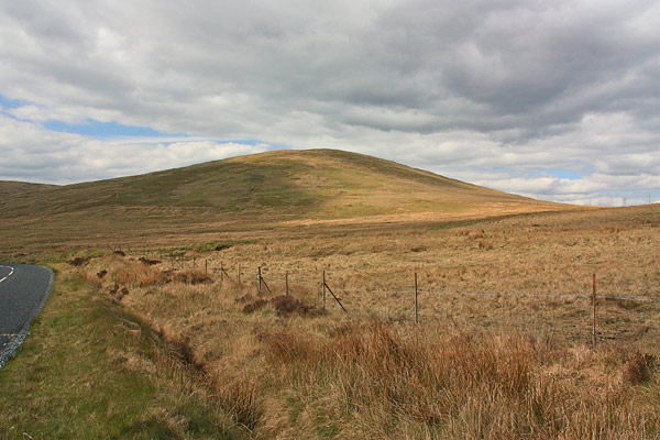
Picture: Butter Mountain from the east.
For a short and simple walk up this hill park at Spelga Dam SplgDm (J268 273). Walk a short way (E) along the road to a track on the left SplgDm (J269 273). Follow this part of the way uphill before striking out NE on a grassy track to gain the high point A (J27478 27981). For modest effort there are rewarding views from the top. East and north to the line of the high Mournes from Slieve Muck to Slieve Meelmore. To the SE over Spelga Dam Pidgeon Rock, Slievemoughanmore and Eagle Mt stand out and nearer at hand Slievenamiskin, Cock and Hen Mts. For an alternatively route park at the Blue Quarry (Ott Track) car park on the Slievenaman Road Ott CP (J280 279). Take the stone steps up from the back of the car park and once over the wooden stile go up W to the top. Once there, for a looped walk, descend by way of the route up from Spelga Dam. Once down at the road go left up to the road junction where another left turn will soon lead back to the start.
I recently did my bronze duke of ed. we started from meelmore lodge, a little lodge with a beautiful morning view of lukes mountain and hare's gap. we hiked to the northern foot of butter mountain and trekked over it to spelga dam. we continued east along the road and went round ott mountain and over the saddle between meelbeg and loughshannagh. beautiful views of doan and part of ben crom reservoir there. we could also see donard. magnificent. we went round meelbeg and went over another saddle between meelbed and bernagh down to fofanny. we hiked along the ulster way and up the trassy track to the camp half way up.
day two and we went down trassy and into tollymore. through tollymore via the southern paths and up the drinns (i cringe at the word!) and out over the plain between tollymore and donard park. through donard park via greenhill YMCA centre and past donard bridge. continuing on through and down out to maggie's leap. an amazing 2 days. the hardest part being the drinns believe it or not. a piece of advice - don't do the drinns in segments, i.e. taking a break every few minutes, like our group did. do it in one go and get it over and done with. then have a good break at the top, with a spectacular view over to, i think, dromore. nicest view - through the saddle between meelbed and loughshannagh Linkback: mountainviews.ie/summit/458/comment/992/
Read Less
Read More
Picture: Perfect Training Ground
CaptainVertigo on Butter Mountain
by CaptainVertigo
5 Mar 2006
A healthy adult ought to make it to the summit of Butter Mountain from the Spelga Dam Car Park in about ten minutes! There's a big reward in terms of views for practically no effort. I brought John(7) and Peter(5) there today, and, really, its a super safe training ground for little people. They have mini walking poles which they love because it gives them that authentic "mountaineer" feeling. I can't think how you'd injure yourself on that grassy slope...short of being dropped from a helicopter head first. The photo shows the wee folk ascending Butter mountain. John's the one with the GPS !!! Linkback: mountainviews.ie/summit/458/comment/2219/
Read Less
Read More
Alex92 on Butter Mountain
by Alex92
13 Apr 2007
I did Butter yesterday while waiting to be picked up in the Ott/Blue Quarry car park, after I camped on the shores of Loughshannagh. It's a nice enough wee dander, and as said in previous contributions, it does provide some great views of Spelga dam, Fofanny dam, Bearnagh, Ott, Carn and the other surrounding mountains, without requiring much effort. Best approach is from Ott/Blue Quarry carpark. Ascend up the granite path to the style, and follow the grassy trail to the summit. Gaiters may be needed, as I found out when the whole of my lower right leg sunk into a bog... not nice! Butter is a good introduction if you're looking to use it in a lengthly walk, and it's a good "training ground" for smaller kids as suggested by CaptainVertigo. One word of warning though: Whatever you do, DO NOT ever leave your car over night in the Ott car park. Recently a car was burnt out after being left over night, and I have had my own experiences where a relative of mine had their car broken into. Alternatively arrange for someone to drop you off and pick you up if you are camping, or use the Mourne Rambler bus service. But parking for daytrips should be fine, just take caution. Linkback: mountainviews.ie/summit/458/comment/2667/
Read Less
Read More
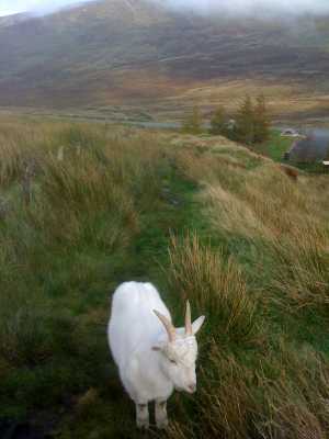
Picture: The Goat bidding me farewell or else he just wants food off me!
wicklore on Butter Mountain
by wicklore
13 Oct 2008
Butter Mountain should have been a quick up and down from the Blue Quarry/Ott car park. However I was distracted by a pure white goat that clearly wanted to follow me. It was only short of clambering over the stile with me which is on the path leading from the car park. When we said our goodbyes at the stile I hauled myself up to the summit trying to get into the “Healthy Adult will do it in 10 minutes” bracket as posted by CaptainVertigo. My previous long hike in the Mournes had made me unhealthy and it took about 18 minutes from the carpark! Nice views of the Spelga Dam and across to cloud topped Meelbeg and Slieve Loughshannagh. Billy Goat awaited below and I knew I had a healthy snack to share with him so I bade farewell to Butter Mountain and the Mournes until another day. Linkback: mountainviews.ie/summit/458/comment/3387/
Read Less
Read More
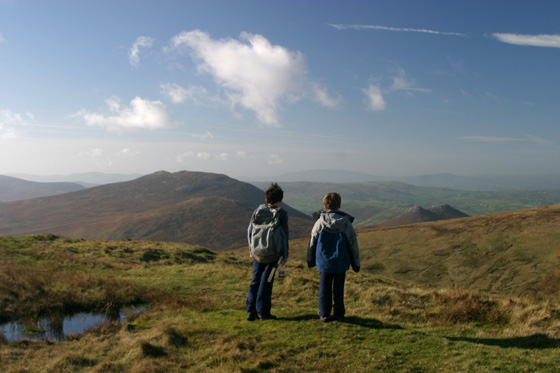
Picture: View W from Butter mt, Cock and Hen mts in foreground.
Following the Mourne Way over Butter Mt.
by Harry Goodman
8 Nov 2011
As described in other members comments there is a short and easy way to climb Butter Mt. There is however a more rewarding alternative route which follows part of the Mourne Way. Starting at the Blue Quarry (Ott Track) car park Ott CP (J280 279) the route is fully described in the WalkNI web site and in an illustrated booklet which can be requested on line. There are fine views NE to the high Mournes and, as the walk follows the wide U shaped ridge on the top of Butter Mt and turns SW Cock and Hen Mts in the Western Mournes and Slieve Gullion in Armagh come into view. On reaching the Spelga Pass road B (J260 280) turn left and at the T junction left again to walk back to the start. If you have two cars leave one at the Spelga Dam Car Park and avoid the road walk back. Linkback: mountainviews.ie/summit/458/comment/4063/
Use of MountainViews is governed by conditions and a privacy policy.
Read general information about the site. Opinions in material here are not necessarily endorsed by MountainViews.
Hillwalking is a risk sport. Information in comments, walks, shared GPS tracks or about starting places may
not be accurate for example as regards safety or access permission. You are responsible for your safety and your permission to walk.
See the credits and list definitions.


 Our Facebook page.