This website uses cookies, which are small text files that the website puts on your device to facilitate operation. Cookies help us provide a better service to you. They are used to track general user traffic information and to help the website function properly.
kburke96: Track/4961 in area near Temple Hill, Galty Mountains (Ireland)
Temple Hill - Lyracappaul - Monabrack Circuit
Ascent: 947m,
Length: 14.0km,
Creator time taken: 4h47m
Descent: 948m,
Time predicted from Naismith's rule: 4h 23m + breaks
Click here to rate track
PlacesStart at Carrigeen (Cargeen) R86920 19652, Temple Hill, Lyracappul, Carrignabinnia, Monabrack, end at Start
Track Rating ..
[RWD version 1 ]
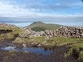
Completed this loop on 15th Oct 2023 - a brilliantly clear and calm day in the Galtees. Space for 2 cars at the start point, but further up the lane there is a larger layby with room for 7-8 cars. After 320m cross the gate on your left onto a forest track which looks to have been recently re-chipped, down as far as a turning circle where an old farm house is hidden in the trees. Follow the well worn track downhill to the left, through a few fields. You get a glimpse of the view into Pigeon Rock glen from here. The fields emerge on to a road where you turn right and walk up to the farm building, crossing the river. Pass through a gate and now you're facing into the curved valley. Keep the stream on your left and ascend alongside it. After about a kilometre there is large water cut on the opposite side of the river, this is a suitable spot to find a crossing point. Now slog up NW aiming to join the track that leads up to Temple Hill. Stop and take in the views of the valley enclosing you and the Knockmealdowns and Comeraghs emerging beyond that. Eventually reach the summit of Temple Hill. From here head E to the col, optionally summit Knockaterriff Beg (marked as Little Bull Hill on EastWest maps), or skirt around it to avoid more elevation gain/loss. Another climb up to Lyracappul now, this one is a little easier than the last. From here it's easy to follow the Galtee Wall for a few hundred metres. The wall would provide good shade and a spot for lunch. From the wall head S following sheep tracks and heading for the base of Monabrack. A final climb from here gets you to the last summit of the day. The descent off Monabrack looks mostly samey-samey. You eventually come to a fence - it looks like people have crossed it previously and continued on down through the field. I following the fence over to the right and crossed at the corner of the forest and continued down a small path between the fence and the forest, eventually passing a farmhouse and back on to the track to the start point.
Editing Details for track/4961
NOTE: ALL information such as Ascent, Length and Creator time taken etc should be regarded as approximate. The creator's comments are opinions and may not be accurate or still correct.
Your time to complete will depend on the speed of the slowest plus break time and your mode of transport.
NOTE: It is up to you to ensure that your route is appropriate for you and your party to follow bearing in mind all factors such as safety, weather conditions, experience and access permission.
Uploaded on: Mon, 16 Oct 2023 (08:19:13), Linkback: https://mountainviews.ie/track/4961/
* Note: A GPS Height in the elevation profile is sourced from the device that recorded the track. An "SRTM" height is derived from a model of elevations for parts of the earth. More detail
Use of MountainViews is governed by conditions and a privacy policy.
Read general information about the site. Opinions in material here are not necessarily endorsed by MountainViews.
Hillwalking is a risk sport. Information in comments, walks, shared GPS tracks or about starting places may
not be accurate for example as regards safety or access permission. You are responsible for your safety and your permission to walk.
See the credits and list definitions.


 Our Facebook page.