This website uses cookies, which are small text files that the website puts on your device to facilitate operation. Cookies help us provide a better service to you. They are used to track general user traffic information and to help the website function properly.
jgfitz: Track/4713 in area near Collon Hill, Wicklow (Ireland)
A pleasant forested walk
Ascent: 223m,
Length: 8.2km,
Creator time taken: 2h36m
Descent: 224m,
Time predicted from Naismith's rule: 2h 0m + breaks
Click here to rate track
PlacesStart at Castletimon Wood North (CstTim) T30158 87802, Collon Hill, end at Start
Track Rating ..
[RWD version 1 ]
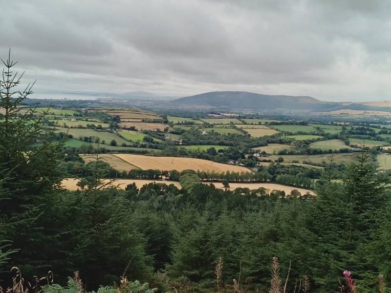
This track is very similar to others already uploaded. On this occasion, we did not include the summit which is a spur off the circular trail. Because of this, we experienced only occasional flashes of the lovely views - on the north towards the Wicklow Head lighthouse and Magherabeg Beach, and on the south towards Barranisky Hill. The track is somewhat overgrown in places, particularly at the southern end, but always passable without too many "reminders" that one is passing through heather.
Looking South towards Barranisky
Dunganstown Castle, situated nearby, is not accessible to visitors as it is in private lands; James II stayed there on his retreat from the Battle of the Boyne in 1690 . Taking advantage of Heritage Week, we finished our walk with a visit to what had once been part of this castle property - Ballymurrin Quaker Farmstead, which dates from 1688 and is still inhabited. It is open to visitors only on special occasions such as Heritage Week. A very informative visit, conducted by the present owner. More information available online.
Editing Details for track/4713
NOTE: ALL information such as Ascent, Length and Creator time taken etc should be regarded as approximate. The creator's comments are opinions and may not be accurate or still correct.
Your time to complete will depend on the speed of the slowest plus break time and your mode of transport.
NOTE: It is up to you to ensure that your route is appropriate for you and your party to follow bearing in mind all factors such as safety, weather conditions, experience and access permission.
Uploaded on: Thu, 18 Aug 2022 (22:13:47), Linkback: https://mountainviews.ie/track/4713/
* Note: A GPS Height in the elevation profile is sourced from the device that recorded the track. An "SRTM" height is derived from a model of elevations for parts of the earth. More detail
Use of MountainViews is governed by conditions and a privacy policy.
Read general information about the site. Opinions in material here are not necessarily endorsed by MountainViews.
Hillwalking is a risk sport. Information in comments, walks, shared GPS tracks or about starting places may
not be accurate for example as regards safety or access permission. You are responsible for your safety and your permission to walk.
See the credits and list definitions.


 Our Facebook page.