This website uses cookies, which are small text files that the website puts on your device to facilitate operation. Cookies help us provide a better service to you. They are used to track general user traffic information and to help the website function properly.
Feature count in area: 19, all in Mayo,
OSI/LPS Maps: 22, 23, EW-WNN
Highest Place: Maumakeogh 379m
Starting Places (9) in area North Mayo: Bangor Trail Head, Carnhill, Carrowmore Wood, Erris Head, Portacloy Bay, Proesoon, Sralagagh West, Termon Hill Road, Tower Hill South
Summits & other features in area North Mayo: Cen: Pulathomas: Barnacuillew 260m E: Ballycastle Hills: Knockaghaleague 237m, Knockboha 186m, Maumakeogh 379m N: Benwee Head Cliffs: Benwee Head 255m, Barradeegin 229m, Glinsk 304m, Illanmaster 238m, Illanmaster Island 105m, Porturlin Hill 155m, Srahataggle 182m, Tawnaghmore 340m S: Bangor Erris Hills: Carrafull 269m, Knocklettercuss 370m, Knocknascollop NW Top 244m, Sheean 295m, Slieve Fyagh 335m W: Belmullet: Aghaglasheen 132m, Termon Hill 103m
Note: this list of places may include island features such as summits, but not
islands as such.
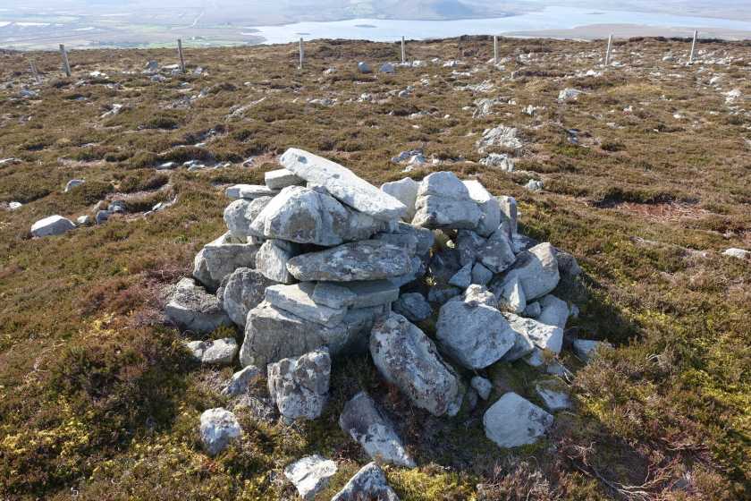
Carrafull, 269mHill
Place Rating ..
, Mayo County in Connacht province, in Binnion Lists, Carrafull is the 1240th highest place in Ireland.
Grid Reference F87067 24678,
OS 1:50k mapsheet 23 Place visited by: 11members, recently by: oakesave, Wilderness, Fergalh, markmjcampion, Garmin, harry66, chalky, FilHil, IncaHoots, Big-Foot, three5four0
I visited this place: NO (You need to be a logged-in member for this.)
Longitude: -9.729537, Latitude: 54.158703, Easting: 87067, Northing: 324678,
Prominence: 164m, Isolation: 4.9km ITM: 487041 824683 Bedrock type: Banded, graded and X-bedded quartzites., (Bangor/Corslieve Formation) Notes on name: This small hill overlooks Bangor in Erris. It is named Garrafull on Bald's map of Mayo, but this variant does not seem to be confirmed by other sources.
Short or GPS IDs, 6 char: Crfl, 10 char: Carrafull Linkback: https://mountainviews.ie/summit/983/
From the cross roads in Bangor (A (F861 231)), walk north up a minor road which shortly turns left, at the next corner B (F859 234) go right through a gate onto a rough track. This runs towards a ruined house, but soon after going through the gate there is a track junction, turn right here and follow this track up hill, pass a wrecked car and continue onto the telecommunication aerials at Srahanarry.
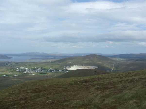
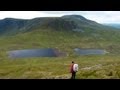
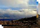
From here walk up hill (beside then passed some cables on the ground) to the first summit and then out to the actual summit of Carrafull. Another great North Mayo view point, despite its modest height. Return is by way of your ascent.
The track & Masts mentioned above are not shown on the older OS series, the track that is shown is overgrown and best avoided. Linkback: mountainviews.ie/summit/983/comment/3719/
Read Less
Read More
Picture: Top of Carrafull
Enjoyable walk with easy access.
by Wilderness
21 Apr 2022
From the center of Bangor I walked east along the N59 for about a kilometre and then turned left up a narrow country road. I followed this narrow road up hill for approximately 500 meters where I came across a gate on my left : C (F874 236).
I accessed Carrafull by climbing this gate, and made my way towards both tops. The good thing about going this way is that you have only one or two wire fences in your way, and they are low and easy to step over.
Fabulous views on top. Linkback: mountainviews.ie/summit/983/comment/23491/
Use of MountainViews is governed by conditions and a privacy policy.
Read general information about the site. Opinions in material here are not necessarily endorsed by MountainViews.
Hillwalking is a risk sport. Information in comments, walks, shared GPS tracks or about starting places may
not be accurate for example as regards safety or access permission. You are responsible for your safety and your permission to walk.
See the credits and list definitions.


 Our Facebook page.