Donation Request 2024

DONATE
Members and Supporters, the MountainViews Committee requests your help to meet the costs of the website and of other activities such as insured events or publications.
You do not have to be logged in to donate.
Features
Nearby features appear when you click the map.
Declutter tracks on map.
Place Search
Video
X
Pub: by
Mourne Mountains Area , N: Castlewellan Subarea
Feature count in area: 58, all in Down, OSI/LPS Maps: 20, 29, EW-CLY
Highest Place: Slieve Donard 849m

Starting Places (33) in area Mourne Mountains:
Alex Steddom Tree, Aughrim Airstrip, Ben Crom Dam, Bloody Bridge Car Park, Carlingford Greenway, Carrick Little, Crocknafeola Wood, Crotlieve Mountain, Donard Car Park Newcastle, Drummanmore Picnic, Fofanny Reservoir, Forest Office CP, Gamekeepers Lodge CP, Happy Valley Trassey Rd, Hen Mountain CP, Leitrim Lodge CP, Mayo Road Corner, Meelmore Lodge, Newcastle Harbour, Ott CP, Red Bog Road, Rourkes Park, Sandy Brae, Silent Valley Reservoir Head Rd, Slieve Donard Trail Head, Slieve Foye Viewing Point, Slievefoy Forest CP, Spelga Dam E, Spelga Dam N, Spelga Dam S, Trassey Car Park, Two Mile River CP, Yellow Water Park

Summits & other features in area Mourne Mountains:
Cen: Loughshannagh: Ben Crom 526m, Carn Mountain 585.2m, Carn Mountain North Top 553.7m, Doan 592.6m, Ott Mountain 526.8m, Slieve Loughshannagh 617m, Slieve Muck 670.4m, Slievenaglogh 445m
E: Binnian: Slieve Binnian 745.9m, Slieve Binnian East Top 639m, Slieve Binnian North Top 678m, Slieve Binnian North Tor 682.5m, Wee Binnian 460m
E: Donard: Chimney Rock Mountain 656m, Crossone 540m, Millstone Mountain 460m, Rocky Mountain 524m, Slieve Donard 849m
E: Lamagan: Cove Mountain 654.8m, Slieve Beg 595.9m, Slievelamagan 702.2m
N: Bearnagh: Slieve Bearnagh 739m, Slieve Bearnagh North Tor 680m, Slieve Meelbeg 701.9m, Slieve Meelmore 687m
N: Castlewellan: Slievenalargy 280m, Slievenaslat 272m
N: Commedagh: Slieve Commedagh 767m, Slieve Corragh 641.9m, Slievenaglogh 584.4m, Slievenaglogh East Top 571m
N: Croob: Cratlieve 429m, Slieve Croob 534m, Slievegarran 391m, Slievenisky 446m
N: Rathfriland: Knockiveagh 235m
S: Kilkeel: Knockchree 306m
S: Rostrevor: Crenville 460m, Finlieve 578m, Slievemartin 485m, Slievemeel 420m, Slievemeen 472m
W: Hilltown: Gruggandoo 382m, Slieveacarnane 296m
W: Slievemoughanmore: Crotlieve Mountain 347m, Eagle Mountain 638m, Rocky Mountain 404m, Shanlieve 626m, Slievemoughanmore 560m, Tievedockaragh 473m, Wee Slievemoughan 428m
W: Spelga: Butter Mountain 500m, Cock Mountain 504m, Cock Mountain South-West Top 505m, Hen Mountain 354m, Pigeon Rock Mountain 534m, Pigeon Rock Mountain South Top 530m, Slievenamiskan 444m

Note: this list of places may include island features such as summits, but not islands as such.
Rating graphic.
Slievenalargy, 280m Hill Sliabh na Leargadh A name in Irish,
Place Rating ..
(Ir. Sliabh na Leargadh [PNNI], 'mountain of the sloping expanse') Tullynasoo Mountain an extra name in English, Down County in Ulster province, in Binnion Lists, Slievenalargy is the 1208th highest place in Ireland.
Grid Reference J29770 35554, OS 1:50k mapsheet 29
Place visited by: 46 members, recently by: garybuz, Paddym99, eflanaga, pdtempan, Jai-mckinney, Kirsty, Carolyn105, dregish, Hoverla, trostanite, PaulNolan, LorraineG60, MichaelG55, Wilderness, Ulsterpooka
I visited this place: NO (You need to be a logged-in member for this.)
Longitude: -6.009698, Latitude: 54.252578, Easting: 329770, Northing: 335554, Prominence: 155m,  Isolation: 3.9km
ITM: 729692 835577
Bedrock type: Granite, granodiorite, (Newry Granodiorite Complex)
Notes on name: Tullynasoo is a townland in the parish of Kilcoo. The name is derived from Ir. Tulaigh na Subh, 'hillock of strawberries'. The name Tullynasoo Mountain probably refers to the mountain pasture of the townland. Slievenalargy appears to be the name of the peak.
  Short or GPS IDs, 6 char: Slvnlr, 10 char: Slvnlrgy

Linkback: https://mountainviews.ie/summit/971/
Gallery for Slievenalargy (Sliabh na Leargadh) and surrounds
No summary yet for this place .
Member Comments for Slievenalargy (Sliabh na Leargadh)
Comment create / edit display placeholder

            MountainViews.ie picture about Slievenalargy (<em>Sliabh na Leargadh</em>)
Picture: Secluded Mass Rock on Slievenalargy
wicklore on Slievenalargy
by wicklore 30 Mar 2010
Driving around Slievenalargy looking for a place to park I spoke to a couple of people on the minor road that skirts to the south of the hill. They told me I could park at the quarry at A (J305 354), and cautioned that I should let the occupants of the house on the lane leading to the quarry know. A good minor road starting at B (J307 352) leads up to the quarry. There was no one at the house when I called. I parked at the quarry anyway, and I left a note in the window of my car with phone number in case there was a problem.

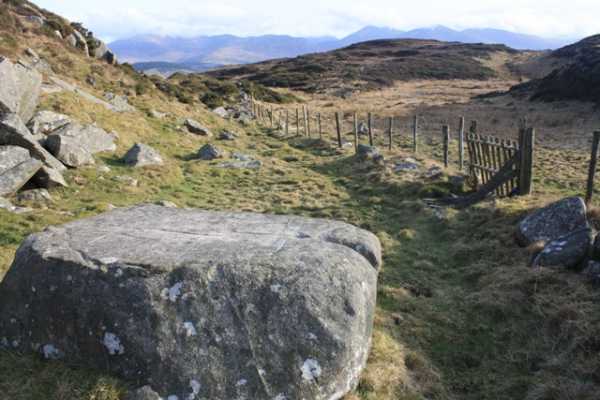
I climbed up to the left of the quarry and picked my way over rough ground to the NW. Fences criss-cross the hill, and I was able to pick up a small trail leading across the hill in the direction of the summit. While Slievenalargy may be one of the quieter Mournes hills, with little evidence of many visitors, it did hold a pleasant surprise in store for me. At approximately 
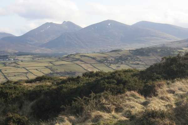
C (J299 356) I discovered a Mass Rock, inscribed with chalice, crosses and the letters ‘IHS’. It was a large block of granite, perhaps 3 feet high and 4 feet wide. It sat nestled between two areas of higher ground, and the views across to the Mournes from it were stunning. It was strange to think it had probably sat here for hundreds of years, and that it had once attracted so many people in secret onto this hill. Now hundreds of years later I was following in their footsteps, for a different reason, but seeing the same views. Letting go of the past I continued on to the summit area, which involved crossing a couple more tricky fences. The top is heathery with a sprinkling of rocks and boulders. The best view is towards the main Mournes, with Slieve Bearnagh, Meelmore and Meelbeg looking fantastic from this angle. Lough Island Reavy Reservoir sparkled just below the hill, and my eye was drawn northwards where I saw distant hills and Lough Neagh.

I retraced my route back to the quarry, pausing once again to admire the Mass Rock. As I moved on, the Rock continued its quiet existence, sitting peacefully in its hidden spot, with the knowledge that it will remain largely unvisited because of its location on this quiet hill.

I would suggest that anyone who wants to park at the quarry should call into the house on the lane to let them know. The quarry is dangerous, and is in use, so permission should be sought. Other than that it’s easy to enjoy the respite of this quiet hill! From the quarry to the summit only took about 30 minutes at a rambling pace, and the biggest challenge is getting over the many fences. Linkback: mountainviews.ie/summit/971/comment/4560/
Read Less
Read More

            MountainViews.ie picture about Slievenalargy (<em>Sliabh na Leargadh</em>)
Picture: Looking south to the Mournes
wicklore on Slievenalargy
by wicklore 30 Mar 2010
Slievenalargy is one of the closest outliers to the north of the main Mourne group. For this reason it offers great views back to its higher and more majestic neighbours. In particular it offers new vistas of familiar hills, such as this photo which shows Slieve Bearnagh, Meelmore and Meelbeg. Linkback: mountainviews.ie/summit/971/comment/4561/
Read Less
Read More

Burnt hill top
by pn_runner 23 Apr 2011
As of April 2011 the gorze above the quarry Wicklore mentions has been burnt off. You can pretty much pick your own route so long as you don't mind blackening your clothes and climbing fences. Linkback: mountainviews.ie/summit/971/comment/6310/
Read Less
Read More
EDIT Point of Interest
text
Videos


Recent Contributions
x
Conditions and Info
Use of MountainViews is governed by conditions and a privacy policy.
Read general information about the site.
Opinions in material here are not necessarily endorsed by MountainViews.
Hillwalking is a risk sport. Information in comments, walks, shared GPS tracks or about starting places may not be accurate for example as regards safety or access permission. You are responsible for your safety and your permission to walk.
See the credits and list definitions.

OSi logo
OSNI/LPS logo
Open Street Map
(Various variations used.)
British summit data courtesy:
Database of British & Irish Hills